1828 Finley Map of New Hampshire
NewHampshire-finley-1828$250.00

Title
New Hampshire.
1828 (undated) 11.5 x 8.75 in (29.21 x 22.225 cm) 1 : 1108000
1828 (undated) 11.5 x 8.75 in (29.21 x 22.225 cm) 1 : 1108000
Description
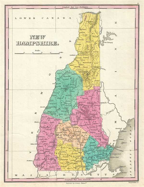
This is an 1828 Anthony Finley map of New Hampshire. The map depicts the state from Canada to Massachusetts and from Vermont to Maine in Finley's classic minimalist style. River ways, roads, canals, and some topographical features are illustrated. Counties are differentiated through the use of different colors of shading. Numerous cities and towns are labeled, including Concord, Charleston, Exeter, and Dover. Mount Monandnock, Mount Moosehillock, and Mount Washington are also identified. It is very uncommon to find an early 19th century exclusively depicting New Hampshire, as most maps of the period bundled it with Vermont.
Engraved by Young and Delleker for the 1828 edition of Anthony Finley's General Atlas.
Engraved by Young and Delleker for the 1828 edition of Anthony Finley's General Atlas.
Cartographer
Anthony Finley (August 25, 1784 - June 9, 1836) was an American book and map publisher based in Philadelphia, Pennsylvania. Finley was born in Philadelphia in 1784. He opened a bookshop and publishing house at the Northeast corner of Fourth and Chestnut Street, Philadelphia in 1809. His earliest known catalog, listing botanical, medical and other scientific works, appeared in 1811. His first maps, engraved for Daniel Edward Clarke’s Travels in Various Countries of Europe, Asia, and Africa also appear in 1811. His first atlas, the Atlas Classica, was published in 1818. He soon thereafter published the more significant A New American Atlas and the New General Atlas…, both going through several editions from 1824 to 1834. Although most of Finley's cartographic material was borrowed from European sources, his atlases were much admired and favorably reviewed. In addition to his work as a printer, Finley ran unsuccessfully on the 1818 Democratic ticket for Philadelphia Common Council. He was a founding officer of the Philadelphia Apprentices’ Library, and a member of both the American Sunday-School Union and the Franklin Institute. He was also an ardent supporter of the American Colonization Society, an organization dedication to returning free people of color to Africa - which led to the founding of Liberia. Much of his wealth was dedicated to supporting this cause. Finley was active as a publisher until his 1836 death, apparently of a 'lingering illness.' Shortly thereafter advertisements began appearing for his map business and plates, most of which were acquired by Samuel Augustus Mitchell. More by this mapmaker...
Source
Finley, Anthony, A New General Atlas, Comprising a Complete Set of Maps, representing the Grand Divisions of the Globe, Together with the several Empires, Kingdoms and States in the World; Compiled from the Best Authorities, and corrected by the Most Recent Discoveries, Philadelphia, 1828.
Condition
Very good. Blank on verso.
References
Cobb, D. A., New Hampshire Maps to 1900; an Annotated Cartobibliography, 104. Rumsey 0285.008 (1831 edition). Phillips (Atlases) 4314, 760, 752, 6045.