This item has been sold, but you can get on the Waitlist to be notified if another example becomes available, or purchase a digital scan.
1865 Currier and Brown / Kensett Map of New Haven, Connecticut
NewHaven-browncurrier-1865$475.00

Title
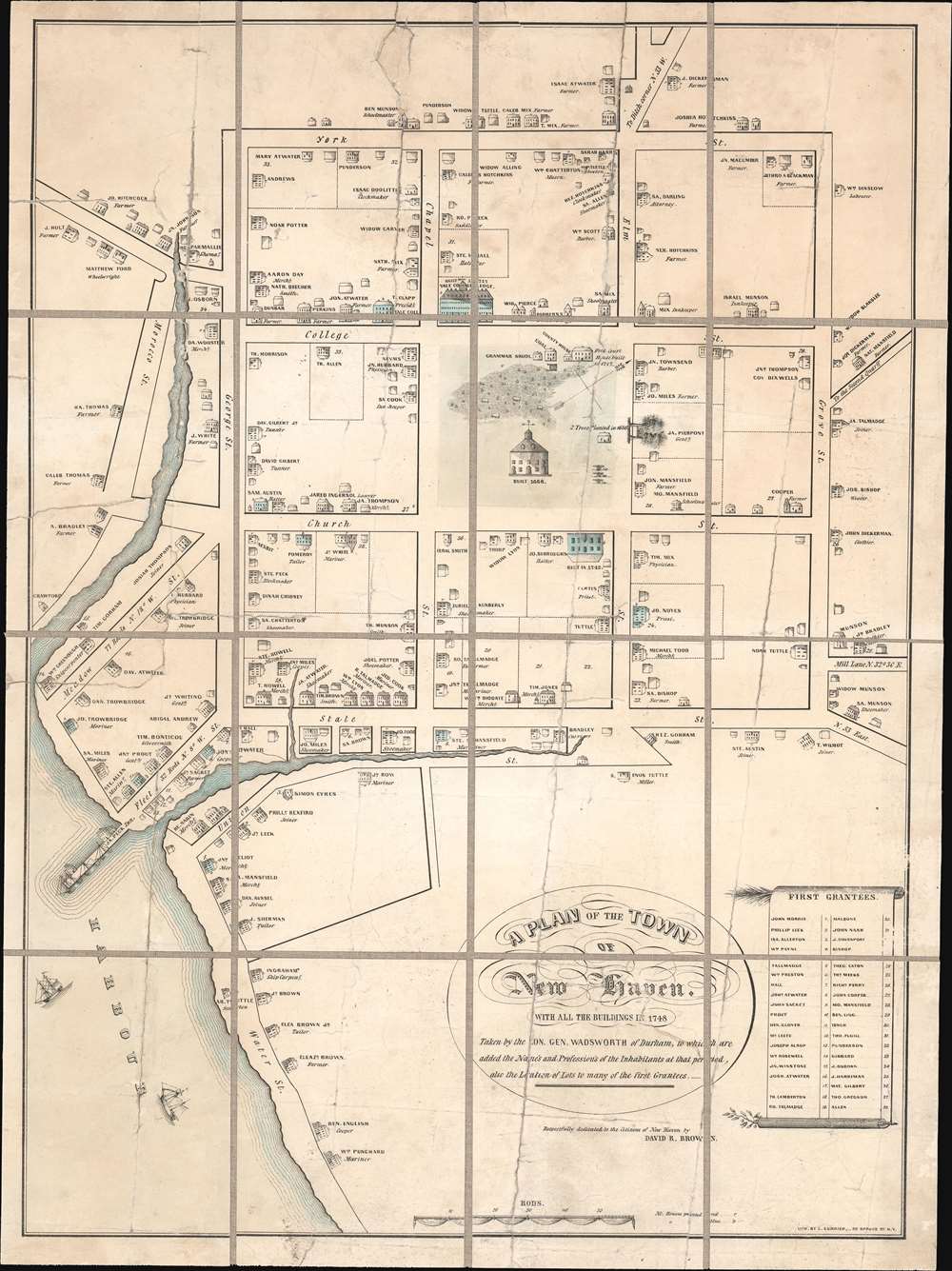
A Plan of the Town of New Haven. With all the Buildings in 1748 Taken by the Hon. Gen. Wadsworth of Durham, To Which Are Added The Name's and Profession's of the Inhabitants at that period, also the Location of Lots to many of the first Grantees.
1865 (undated) 22.5 x 17 in (57.15 x 43.18 cm) 1 : 3000
1865 (undated) 22.5 x 17 in (57.15 x 43.18 cm) 1 : 3000
Description
This is a c. 1865 Charles Currier and David R. Brown lithographic reissue of the 1806 Thomas Kensett / James Wadsworth map of New Haven, Connecticut, as it appeared in 1748. The Kensett / Wadsworth map is considered to be the earliest map of New Haven. The map is oriented roughly to the northwest and covers the 9 city blocks surrounding the New Haven Green. It further extends to incorporate the harbor and nearby waterways, most of which have since been altered by landfill projects. The identifies Yale University (built in 1717), the city hall (constructed in 1668), and two trees on the Green plated in 1686. It further notes the location of various c. 1748 private residences, noting the owner's name and profession. In the lower right quadrant, there appears a list of the original 38 grantees, most of which also appear on the map.
Differences between this and the Wadsworth/Kensett Map
The architect David R. Brown, working with Charles Currier, issued this reprint of the first published map of New Haven. The original was drawn by James Wadsworth (1730 - 1817) in 1748, but not printed until 1806, when it in fell into the hand of Thomas Kensett (1786 - 1829). Brown's reissue of the map is on a smaller scale and simpler in execution than the Wadsworth/Kensett original. The elaborate border of the 1806 map has been replaced by a single line, and the calligraphic typography has been supplemented by more modern block lettering. Brown was a skilled draftsman and may have redrawn this later version himself shortly after he returned to New Haven, after fighting for the Union in the American Civil War (1861 - 1865), hence the usual dating of this map to 1865. In addition, several street names and other cartographic data missing from the original have here been added. While the original map was dedicated to The Connecticut Academy of Arts and Sciences, Brown changed the dedication to the 'Citizens of New Haven'. The change is indicative of the fact that this map was intended for a local audience, who perhaps in the post-Civil War years waxed halcyon for the Colonial Era.Publication History and Census
This map was published in partnership by the engraver and lithographer Charles Currier and the New Haven architect David R. Brown. The map is well represented institutionally but rare to the market.CartographerS
Charles Jacob Currier (February 8, 1819 - December 4, 1887) was an American publisher, lithographer, and engraver active in New York during the second half of the 19th century. He was born in Roxbury, Massachusetts. Currier is often overshadowed by his older brother, Nathaniel Currier, of the Currier and Ives firm. While Charles Currier is sometimes associated with Currier and Ives, and with Nathaniel Currier separately, he also published independently under his own imprint. It was Charles Currier who introduced Nathaniel Currier (1813 - 1888), to his brother-in-law James Merritt Ives (1824 - 1895), who eventually partnered in 1857 to found one of the predominate graphic publishing firms in American history, Currier and Ives. He died in Brookline, Massachusetts and is buried in Greenwood Cemetery, Brooklyn. More by this mapmaker...
David R. Brown (May 30, 1831 - February 22, 1911) was an American architect based in New Haven, Connecticut during the second half of the 19th century. Brown was born in New Haven, where he grew up attending the local public schools. He apprenticed as an architect under Henry Austin, also of New Haven. Upon reaching his maturity, he became a partner in the Austin firm. In 1856, he relocated to Chicago, where he prospered. Despite his success in Chicago, he returned to New Haven in 1860, just in time to be recruited into the Union Army. Brown served as a Second Lieutenant and then Captain in the American Civil War. He was part of the 20th Regiment, Connecticut Infantry until its end, in 1865. Returning to New Haven, he continued his architecture practice. He took the young German immigrant Ferdinand Von Beren (1870 - ????) as an apprentice in 1885. In 1890, Von Beren became a partner in the new firm, Brown and Von Beren. Von Beren took full control of the firm after David Brown died in 1911. While there are many examples of Brown's architecture in New Haven and New York, he cartographic works are limited to a single map of New Haven, published with Charles Currier in 1865. Learn More...
Condition
Average. Map exhibits numerous old damages, all of which have beens stabilized. Dissected and laid on linen in 16 sections. Relined with fresh linen.
References
OCLC 793032526.