This item has been sold, but you can get on the Waitlist to be notified if another example becomes available, or purchase a digital scan.
1928 Milligan Pictorial City Map or Plan of New Haven, Connecticut
NewHaven-milligan-1928$500.00

Title
New Haven.
1928 (dated) 27.5 x 35.5 in (69.85 x 90.17 cm) 1 : 24000
1928 (dated) 27.5 x 35.5 in (69.85 x 90.17 cm) 1 : 24000
Description
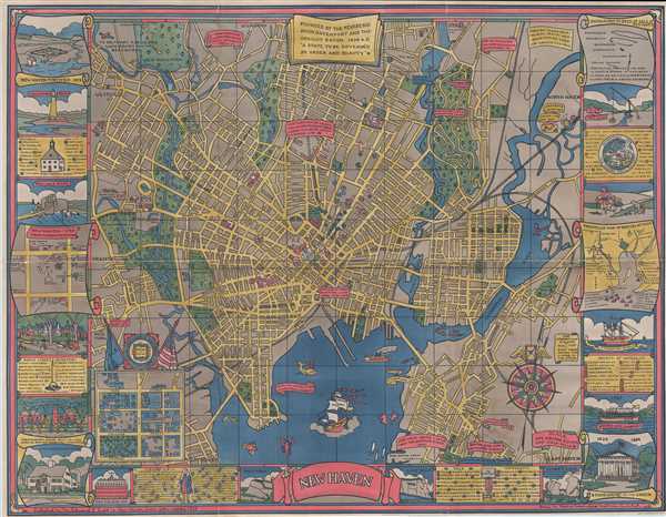
This is a 1928 Carina Eaglesfield Mortimer pictorial city map or plan of New Haven, Connecticut. The map depicts the city from Westville and Orange to the Quinnipiac River, North Haven, and Fairmont Park and from West Rock Park to Fort Wooster Park. Showcasing New Haven's long and storied history, Mortimer's map illustrates the prominent place education holds in the city. Twenty-nine different buildings associated with Yale University and situated throughout the city are identified numerically. They are labeled by blue circles containing a number, which correspond to an index situated along the bottom border to the right of the title. Eighteen other points of interest in the city are indicated by red circles containing numbers, with this index included along the right border near the bottom right corner. Another set of locations, indicated by red squares containing letters, correspond to an index along the right border near the upper right corner. A final index, situated in the upper left portion of the border, corresponds to blue boxes containing letters illustrated on the map which label schools in New Haven.
All these locations are identified on the large central city plan, on which all streets are labeled, along with city parks, cemeteries, and other buildings. Railroad lines within the city are also illustrated. The Yale University Coat of Arms is included in the lower left corner. Other historic sites are labeled through text boxes, such as the site of Eli Whitney's gun factory, the home of a pilgrim, and the Boston Post Road to New York. An inset map, situated on the lower left, depicts central New Haven from between Park Street and York Street to Temp Street and from Chapel Street to Grove Street. Fifty-seven different buildings are numerically labeled and correspond to an index directly below the inset map.
A Border consisting of various vignettes, indexes, and small maps encircles the central map on three sides. Some of the illustrations include vignettes of a fortified New Haven, lighthouse point, the ruins of Fort Hale, the Pierpont House, West Rock, East Rock, the Statehouse on the Green, Fitch's Steamboat, and an old well sweep. Two inset maps also map up the border: one is a sketch of New Haven in 1748 from the Wadsworth Map and the other is a sketch of Pres. Stiles' Map of the British Attack.
This map was drawn by Carina Eaglesfield Mortimer and published by the Edward P. Judd Company in 1928.
Cartographer
Carina Eaglesfield Mortimer Milligan (March 19, 1890 - September 12, 1978) was an American architect. Born in Indianapolis, Indiana to James Theophilius Eaglesfield and Caroline Buckley Campbell, Milligan attended Sweet Briar College and the Cambridge School of Domestic Architecture. She designed houses, which were advertised in local newspapers. After the outbreak of World War II, Milligan worked with Miss Anne Morgan in the Comite American de Secour Civil in France. She married Ernest Mortimer in 1923, who died in 1937, and John Raymond Milligan in 1941, who died in 1959. More by this mapmaker...
Condition
Very good. Backed on archival tissue for stability. Close right margin. Blank on verso.
References
Rumsey 7916.000. New Haven Museum Whitney Library Call Number G3784.N4M676 1928. OCLC 668395148.