This item has been sold, but you can get on the Waitlist to be notified if another example becomes available, or purchase a digital scan.
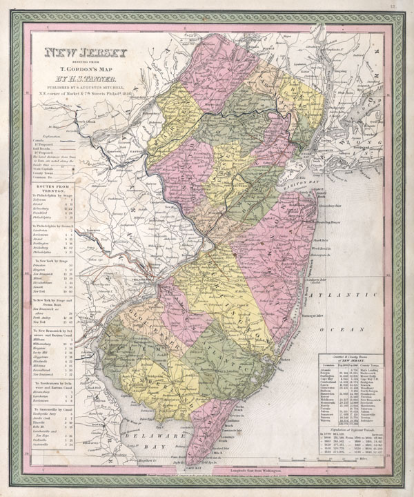
1846 Mitchell / Tanner Map of New Jersey
NewJersey-mitchell-1848$150.00

Title
New Jersey reduced from T. Gordon's Map by H. S. Tanner, Published by S. Augustus Mitchell.
1846 (dated) 15 x 12.5 in (38.1 x 31.75 cm)
1846 (dated) 15 x 12.5 in (38.1 x 31.75 cm)
Description
A fine example of Mitchell's c. 1846 map New Jersey. A highly unusual state of this map. In 1846 Mitchell published two editions of the New Universal Atlas, one edition with the Cary and Hart imprint and borders and another with his own Mitchell imprint and slightly different borders. The Rumsey example, from the first, 1846 issue of the atlas, features the Cary and Hart borders. This issue, though cartographically identical and maintaining the 1846 date, has borders more common in later Mitchell Atlases. However, the copyright on the map remains the same as the earlier Tanner maps – in this instance 'T. Gordon.' The map itself is based upon Tanner's 1834 reduction of Thomas Gordon's seminal 1828 Map of New Jersey. Prepared for inclusion as map no. 12 in the 1847 issue of Mitchell's New General Atlas. Dated and copyrighted, 'Entered according to Act of Congress in the Year 1834 by T. Gordon in the Clerk's Office of the District Court of New Jersey.'
Cartographer
Samuel Augustus Mitchell (March 20, 1792 - December 20, 1868) began his map publishing career in the early 1830s. Mitchell was born in Bristol, Connecticut. He relocated to Philadelphia in 1821. Having worked as a school teacher and a geographical writer, Mitchell was frustrated with the low quality and inaccuracy of school texts of the period. His first maps were an attempt to rectify this problem. In the next 20 years Mitchell would become the most prominent American map publisher of the mid-19th century. Mitchell worked with prominent engravers J. H. Young, H. S. Tanner, and H. N. Burroughs before attaining the full copyright on his maps in 1847. In 1849 Mitchell either partnered with or sold his plates to Thomas, Cowperthwait and Company who continued to publish the Mitchell's Universal Atlas. By about 1856 most of the Mitchell plates and copyrights were acquired by Charles Desilver who continued to publish the maps, many with modified borders and color schemes, until Mitchell's son, Samuel Augustus Mitchell Junior, entered the picture. In 1859, S.A. Mitchell Jr. purchased most of the plates back from Desilver and introduced his own floral motif border. From 1860 on, he published his own editions of the New General Atlas. The younger Mitchell became as prominent as his father, publishing maps and atlases until 1887, when most of the copyrights were again sold and the Mitchell firm closed its doors for the final time. More by this mapmaker...
Source
A New Universal Atlas Containing Maps of the various Empires, Kingdoms, States and Republics Of The World. (1846 Mitchell issue)
Condition
Very good condition. Minor toning.
References
Rumsey 0537.013. Phillips (Atlases) 6103-12. Ristow page 311.