This item has been sold, but you can get on the Waitlist to be notified if another example becomes available, or purchase a digital scan.
1940 Cheng Map or Plan of Shanghai Concessions, China (English language)
NewMapShanghai-cheng-1940$337.50

Title
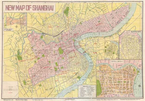
New Map of Shanghai.
1940 (dated) 20 x 29 in (50.8 x 73.66 cm) 1 : 24000
1940 (dated) 20 x 29 in (50.8 x 73.66 cm) 1 : 24000
Description
This is an incredibly rare 1940 Shao Cheng city plan of the concessions in Shanghai, China during the Japanese occupation in World War II. Following the initial Japanese occupation of Shanghai, the Japanese avoided direct conflict with the international powers in the International Settlement and the French Concession, leaving the people there in an oasis of peace and prosperity in a war-torn city. This map was published in the concessions during this highly volatile and ephemeral period.
The map depicts, in striking detail, the International Settlement and French Concession in Shanghai along the Whangpoo River, as well as the areas immediately surrounding them. Neither the International Settlement nor the French Concession are labeled as such on the map, they are depicted together, colored the same shade of pink, and denoted as 'The Special District' in red block lettering. The areas around these two zones are shown in yellow, which drastically sets them apart the two internationals concessions. All roads (both inside and out of the two international zones), as well as parks, cemeteries, schools, and important municipal buildings, such as police stations and hospitals are labeled. Sports fields, the race track, and certain bookstores are also located. Tramways and bus routes are depicted. The map features four insets. One depicts what is called the 'native city', which is located just outside of the concessions. The second focuses on the Central District and the Bund in detail. The third presents 'Shanghai Central of Municipal District'. The fourth, and final, inset depicts the Western District Extension.
This map was published in 1940, or approximately three years after the fall of Shanghai to the Imperial Japanese Army. The occupying Japanese forces decided to leave the International Settlement and the French Concession alone, and did not occupy them until after the attack on Pearl Harbor on December 7, 1941 (which was December 8 in China). Until then, the International Settlement and the French Concession were surrounded by Japanese occupation forces and Chinese citizens, those who actively resisted the Japanese occupation, and others who did not. Many refugees sought sanctuary in the safety of the international zones. Following the Japanese occupation of the International Settlement and the French Concession, European and American citizens were at first forced to wear special arm bands to identify themselves, but were eventually sent to work camps on the outskirts of Shanghai. Most were interned from 1943 until liberation in 1945.
This map was drawn by Shao Cheng, edited by Ke Lang, issued by Ya Kwang Geographical Institute, and published by The Asia Geographical Institute in 1940. The map declares that it is a first edition from July of 1940. After the liberation, in 1945, this map was reissued. Some examples from the 1945 edition bear the 1940 date, but have an updated date on the envelope or binder. Others feature the dated updated to 1945. Both 1945 editions appearing on the market from time to time. On the other hand, we have not seen another example of the 1940 edition. This map would make an incredible addition to any collection, but particularly those focused toward the Second World War in Asia.
Cartographer
Fusazō Sugie (杉江房造; fl. c. 1910 – 1950) was a Japanese bookseller, printer, and active in Shanghai during the final years of the Qing. Fusazō was the owner of the Nihon-do Japanese Bookstore (日本堂書店) in Shanghai, located at 155 Hong-Kou-Wen Street and 237 Woosung Road. He issued numerous guidebooks, souvenir photo books, and maps associated with Shanghai and Nanjing, many of which were bilingual and marketed to American and European tourists and servicemen. His bilingual New Map of Shanghai, published in various states and editions from 1931 well into the 1940s, is his most notable cartographic work. More by this mapmaker...
Condition
Very good. Backed on archival tissue for stability.
References
OCLC 747538997. National Library of Australia, 6857727.