This item has been sold, but you can get on the Waitlist to be notified if another example becomes available, or purchase a digital scan.
1876 Gray Map of Texas and the Indian Territory
NewMapTexas-gray-1876$185.00

Title
Gray's New Map of Texas and the Indian Territory.
1876 (dated) 17 x 26.5 in (43.18 x 67.31 cm) 1 : 2851200
1876 (dated) 17 x 26.5 in (43.18 x 67.31 cm) 1 : 2851200
Description
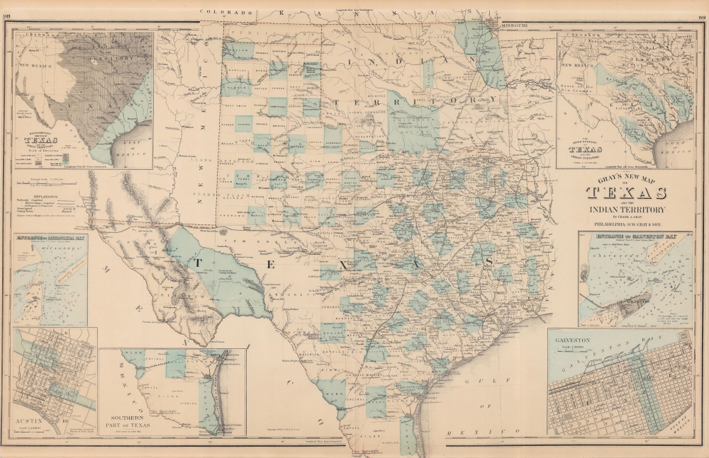
This is an 1876 Frank A. Gray map of Texas and the Indian Territory (Oklahoma) detailing the railroad network during an era of expansion.
A Closer Look
Texas' extensive railroad network appears in detail with each route is labeled. Among these are the Texas and Pacific Railroad and the International and Great Northern Railroad. However, no railroads serve northwestern Texas or the Panhandle. Counties are identified throughout, with myriad cities, towns, and villages labeled, such as Austin (Austin City), Houston, Dallas, Waco, and Corpus Christi. In Indian Territory, land given to various Native Americans is identified by the tribe, including the Chickasaw, Choctaw, Cherokee, and Pottawatomie. A single railroad crosses Indian Territory: the Missouri, Kansas, and Texas Railroad. The Oklahoma Panhandle is labeled as Public Land.Inset Maps
Numerous inset maps appear around the central map. Starting in the upper right corner and proceeding clockwise, these maps detail the river systems of Texas and the Indian Territory, the entrance to Galveston Bay, a city plan of Galveston, the southern part of Texas from Corpus Christi to Brownsville, a city plan of Austin, the entrance to Matagorda Bay, and the elevation of Texas and the Indian Territory in a hypsometric map.Publication History and Census
This map was created by Frank A. Gray and published by O.W. Gray and Son in the 1876 edition of The National Atlas. We note nine examples of the separate map cataloged in OCLC which are part of the collections at the University of Kentucky, Northeastern State University, Southern Methodist University, the University of Texas at Arlington, the Houston Public Library, the University of Houston, Baylor University, the Texas State Library and Archives Commission, and the Denver Public Library.CartographerS
Frank Arnold Gray (September 4, 1852 - September 17, 1886) was an American map publisher. Born in Bernardston, Massachusetts, Gray worked with his father Ormando Wyllis Gray (1829 - 1912) at their publishing firm O. W. Gray and Son. He married Sallie Josephine Paulson on September 1, 1885. They had at least one child. More by this mapmaker...
Ormando Wyllis Gray (March 3, 1829 – July 6, 1912) was a mid to late 19th century map publisher with offices in New York City, Philadelphia, PA, and Danielsonville, Connecticut. Born in Townshend, Vermont, he attended Norwich College where he studied civil engineering and became a civil engineer and surveyor. Gray's first commercial atlas was an 1869 survey of Windhamd and Toland counties, Connecticut. His most important work seems to have been done in conjunction with other, more prominent map publishers, including Henry Walling and G.W. and C.B. Colton. Gray is best known for his state and county atlases, though did, with his sons, also independently issue at least two national atlases in the late 1870s. He retired from the map publishing business in 1890. He died at home in Bernardston, Massachusetts. He married Roxcena L. Arnold in 1851, with whom he had three daughters and one son. Learn More...
Source
Gray and Son, The National Atlas, (Philadelphia: Gray and Son) 1876.
Condition
Good. Verso repairs to centerfold separations. Closed margin tears professionally repaired on verso.
References
OCLC 52709780.