
1851 / 1885 Parke and Kern Map of New Mexico Territory

This item has been sold.
Map of the Territory of New Mexico...
Most Important Early Map of the New Mexico Territory.
- Digital Map Information
- Suitable for large format printing
- Full resolution TIFF file
- ICC color profile embedded
- Delivered instantly via download link
Most Important Early Map of the New Mexico Territory.
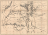
This is the extremely rare, unpublished 1851 map of the Territory of New Mexico produced by John G. Parke and Richard Kern. Known as the Parke-Kern Map, it was printed within the War Department and separately issued on an individual basis but never included in a Congressional Report, as were other key early maps of the American West. The map was then reprinted several times in the late 19th and early 20th century with no obvious changes, but which can be distinguished from the original plate by very close examination. The present example is one of these later, c. 1900, reissues, which in themselves are still very rare.A Closer Look
The map covers a large portion of the American Southwest, from Servier Lake and Pikes Peak in the north to Cooke's Wagon Route in Sonora and Chihuahua, utilized by the Mormon Battalion in the Mexican-American War, in the south. In addition to today's New Mexico and Arizona, and the aforementioned Sonora and Chihuahua, the map covers portions of California, Nevada, Utah, Colorado, Oklahoma, and Texas. Mountains and waterways are indicated throughout, as are existing and proposed trails, Native American settlements, non-indigenous settlements (including El Paso, Albuquerque, and Santa Fe, connected by the Camino Real de Tierra Adentro), forts, mines, and mountain passes. Native American groups are referred to in all caps. Helpful explanatory notes are included, mentioning earlier expeditions and information from mountain men like 'Old Bill' Williams, who was killed with Richard Kern's brother in 1849. Perhaps the most striking feature is how much territory, particularly away from the relatively well-traveled route following the Rio Grande, is marked as 'Unexplored' in large letters or left blank.Historical Context
Following the 1848 Treaty of Guadalupe Hidalgo, the United States formally organized the Territory of New Mexico under the Compromise of 1850. This legislation resolved a volatile border dispute with Texas, which had aggressively claimed all land east of the Rio Grande, including Santa Fe; in exchange for federal assumption of its public debt, Texas relinquished these claims. Over the next decade, the territory's boundaries underwent dramatic reshaping. The Gadsden Purchase of 1853-54 added nearly 30,000 square miles across present-day southern New Mexico and Arizona, clarifying the southern border with Mexico and securing a viable route for a southern transcontinental railroad. The territory was trimmed down in the early 1860s to help form the Colorado and Arizona Territories, finally outlining New Mexico's modern state borders.This period of political reconfiguration was accompanied by intense conflict with local Indigenous nations, including the Apache, Navajo, Ute, and Comanche. Having defended their sovereignty for centuries against Spanish and Mexican control, these tribes fiercely resisted federal military presence, Anglo-American settlement, and land encroachment along vital routes like the Santa Fe Trail. To enforce control and clear land for settlement, the U.S. Army constructed a network of forts across the region, triggering decades of violent clashes. Tensions peaked during the 1860s with aggressive military campaigns, the legacy of which would define the region's history for decades afterward.
Publication History and Census
This map was prepared by John G. Parke and Richard H. Kern of the U.S. Corps of Topographical Engineers in 1851. Their manuscript was printed by J. and D. Major for the War Department to be used by officers deployed to the region and for members of Congress or other leaders who requested copies, but was never printed for a Congressional report or other official publication. According to Richard Kern biographer David J. Weber, 3,750 copies of the map were printed but, if so, only a fraction have survived. Original examples are extremely rare and only come to market a small handful of times each decade.Contemporary Mexican cartographer Manuel Orozco y Berra claimed that a French printing of the map followed soon after its War Department printing, though, if so, it appears to be rather indistinguishable from the War Department printing (see, for reference, the example digitized by the Bibliothèque nationale de France and included in the Wikimedia Commons). A facsimile of the map was printed in the 1915 book The official correspondence of James S. Calhoun while Indian agent at Santa Fé and superintendent of Indian Affairs in New Mexico, edited by Annie Heloise Abel, but can be quickly distinguished by a printed number (it was one of four such facsimile maps in the book) on the verso. Instead, the present example appears to be a late-19th-century reissue - distinguishable from the original by a close examination of details such as the lettering and hachure lines - but in itself is quite rare. Although other examples of the reissue have occasionally come to market, as there is no obvious distinguishing feature compared to the original, it is possible that examples cataloged or sold in the past as 1851 originals are in fact this later reissue.
The OCLC records examples of the original at the Bibliothèque nationale de France and Princeton University, while the American Antiquarian Society holds a later example noted as being a photolithograph. Several other listings in the OCLC are dated 1851 but in fact refer to photocopies and film negatives of the original map or later (mid-late 20th century) reproductions. Some other original 1851 examples or late 19th-century reissues are likely held at a small handful of institutions; for instance, Harvard University, Yale University, and Stanford University catalog 1851 originals (Phillips refers to an example at the Library of Congress, but it does not appear in their online catalog).
Cartographers
John Grubb Parke (September 22, 1827 - December 16, 1900) was a U.S. Army engineer, cartographer, and officer active in the American West after the Mexican-American War, later serving as a general in the U.S. Civil War. Parke was born in Chester County, Pennsylvania, and moved to Philadelphia with his family when he was 8. He attended West Point, graduating second in his class in 1849 and joining the Corps of Topographical Engineers. He conducted surveys in the central and western U.S., much of it newly acquired territory, including work on the Pacific Railroad Surveys. Some of his maps were the most detailed and extensive in existence when produced, such as his 1851 map of the New Mexico Territory. In 1857-61, he was the chief surveyor for a group tasked with designating a northwestern boundary of the U.S., long a sore issue in U.S.-British relations. Parke began the Civil War as a division commander in the Army of the Potomac and then served as Chief of Staff to General Ambrose Burnside, including during the battles of Antietam and Fredericksburg. He was then assigned to the Western Theater and participated in the Vicksburg Campaign. Parke then returned to Virginia, including a stint under Burnside again, through the culminating campaigns of the war. After the Civil War, he returned to his work as an engineer and topographer, including finalizing the U.S.-Canada border in the Pacific Northwest. Then he served as the Superintendent of West Point in 1887-89. He later worked as the director of several banks and was the president of the veterans' group, the Society of the Army of the Potomac. In June 1867, Parke married Ellen Blight (d. 1903), also of Philadelphia, the widow of a fellow topographical engineer who had died of disease during the Civil War; the couple had no children. Further Details...
Richard Hovenden Kern (1821 - October 27, 1853) was an American artist and explorer of the American West. Born in Philadelphia, Kern's two brothers, Benjamin (1818 - March 1849), a physician, and Edward (c. 1822 - November 25, 1863), an artist and topographer, were also important figures in the exploration and early artistic depictions of the American West in the years immediately after the Mexican-American War. All three brothers had received artistic training in their youth, with Richard working as a drawing instructor from a young age and exhibiting landscape and figure studies beginning in 1840. All three brothers were attracted to the American West and were members of John C. Fremont's ill-fated fourth expedition in 1848 - 1849, in which Benjamin Kern and the mountain man 'Old Bill' Williams were killed by Ute Indians amid a tense period of fighting between the Utes and U.S. troops. Richard and Edward Kern remained in New Mexico to work for the Corps of Topographical Engineers and joined several exploratory expeditions, producing maps as well as some of the earliest American illustrations of the life of the Indians of the newly American territory. In 1853, Edward joined the expedition of Lieutenant John Pope (later a top Union general in the Civil War) to survey a route between Santa Fe and Ft. Leavenworth. Meanwhile, Richard Kern joined the Gunnison–Beckwith Expedition surveying potential routes for a Pacific railroad (the Pacific Railroad Survey). While near Sevier Lake in today's Utah, a group of Gunnison's men, including Gunnison himself and Richard Kern, were attacked by Pahvants (Ute) Indians and killed. The Kern River and later Kern County, California, were named in honor of the brothers, particularly Edward, who had discovered the river on Fremont's third expedition in 1845. Some of Richard Kern's sketches appeared as lithographs in congressional reports and the published, multi-volume report on the Pacific Railroad Surveys. Still, many did not, with a portion later redone as paintings by John Mix Stanley (1814-1872). A biography of Kern by David J. Weber was published in 1985 by the Amon Carter Museum, titled Richard H. Kern: Expeditionary Artist in the Far Southwest, 1848-1853. Further Details...
John Major (fl. c. 1835 – 1854) was a New York based engraver and lithographer active in the middle part of the 19th century. Major began his career in New York as an engraver in 1835. In 1839, he adapted to the new innovation of lithography, founding John Major's Lithography with offices at 49 Wall Street. From 1850 his partner in the lithography business was Daniel Major, perhaps his son. They jointly acquired the lithography business of Peter Mesier, also based at 49 wall street, in 1850. It is unclear how exactly John Major was connected to the family of James Major, Henry Broughman Major, and Alfred Sarony Major, who were business partners with acclaimed lithographer and photographer Napoleon Sarony in the New York City lithographic printing world at the same time, a question complicated by the closeness of the names of John and James Major. But it seems very likely that John Major was part of the same extended family. Further Details...
Condition
Good. Laid down on archival paper.
References
OCLC 982304484. Phillips, America, pp. 494. Wheat, Mapping the American West, pp. 131-132; Wheat, Mapping the Transmississippi West, #730.