This item has been sold, but you can get on the Waitlist to be notified if another example becomes available, or purchase a digital scan.
1929 Guillot and Adam City Map or Plan of New Orleans, Louisiana
NewOrleans-guillot-1929$150.00

Title
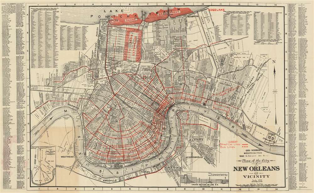
Map of the City of New Orleans and Vicinity. July 1925.
1925 (dated) 21 x 34 in (53.34 x 86.36 cm) 1 : 30500
1925 (dated) 21 x 34 in (53.34 x 86.36 cm) 1 : 30500
Description
This is a 1929 A.H. Guillot and L.J. Adam city map or plan of New Orleans, Louisiana. The map depicts the city from Southport and Westwego to Port Chalmette and from Lake Pontchartrain to the Mississippi River and Amesville. Illustrating New Orleans in a high level of detail, myriad streets are depicted and labeled throughout the city. Numerous planned city improvements are highlighted in red, including a development along the banks of Lake Pontchartrain and an extension of the city park covering an area of approximately fourteen city blocks square from Florida Avenue to Robert E. Lee Boulevard and from Orleans Avenue to the Bayou St. John. Street car lines (solid lines) and bus lines (dashed lines) are illustrated by red overprinting, as is the International Trade Exhibition, which is located along the Mississippi River. Ferry routes across the Mississippi are also noted, as is the depth of the river. Concentric circles extend from the city center, marking one-mile intervals from the French Quarter. The limits of Orleans Parish, Jefferson Parish, and St. Bernard Parish are also illustrated. A street inded is present along both the right and left borders, as is an index of street names that had changed as of February 20, 1924. An inset map, situated in the lower left corner, depicts the districts of New Orleans.
Publication History and Census
This map was created by A. H. Guillot and L. J. Adam in July 1925 and published in 1929. This map is part of eight institutional collections but is rare on the private market.Condition
Very good. Even overall toning. Light wear along original fold lines. Blank on verso.
References
OCLC 40764442.