1946 Polish Embassy Pictorial Map of Poland - 'The New Poland'
NewPoland-polishembassy-1946$1,250.00

Title
The New Poland.
1946 (undated) 29.25 x 21.25 in (74.295 x 53.975 cm)
1946 (undated) 29.25 x 21.25 in (74.295 x 53.975 cm)
Description
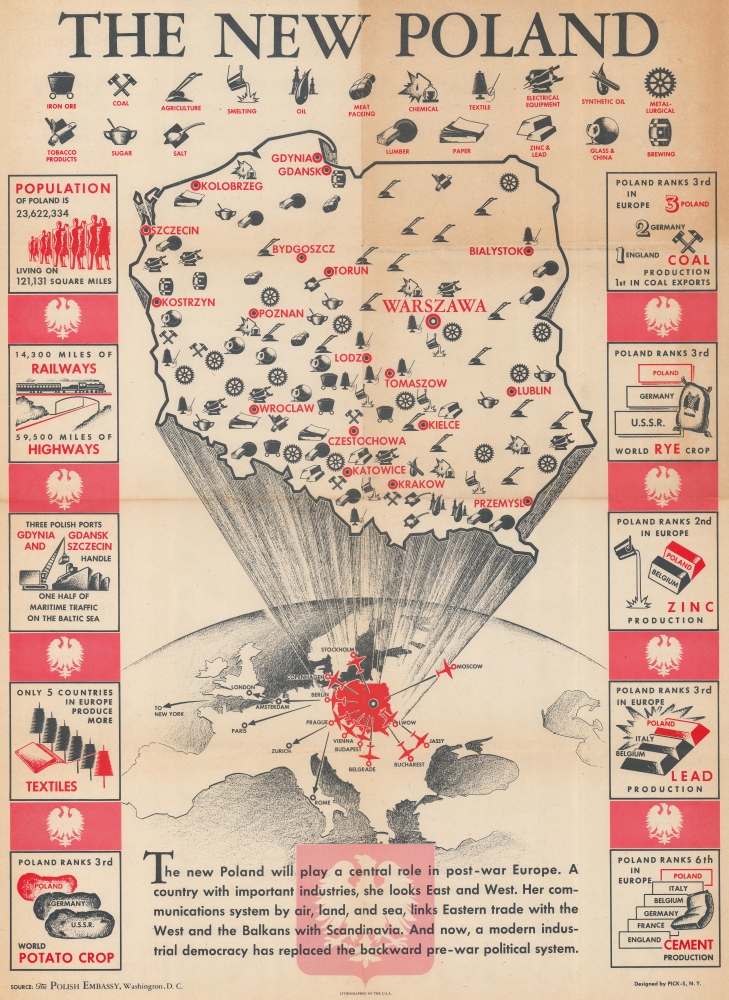
This is a c. 1946 PICK-S pictorial map of Poland after World War II emphasizing Poland's post-war role in Europe and underscoring the looming threat of Soviet communism. It was created in conjunction with the Polish Embassy in Washington, D.C. for distribution in the United States.
A Closer Look
A map of Poland dominates the sheet with pictorial icons marking Poland's industries and natural resources. Among these are electrical equipment, lumber, chemical, meat packing, coal, sugar, salt, and oil. Infographics along the left and right side proclaim Poland's population, railroad and highway network, and its industrial standing when compared with other countries across Europe and the world. Text at the bottom heralds Poland's progress and its importance to European trade as a connection between the East and the West.The New Poland
As a phrase, 'The New Poland' has been used at least twice in 20th century history: once after World War I (1914 - 1918) and again after World War II (1939 - 1945). In this context, The New Poland refers to Poland after World War II and likely before the establishment of the Republic of Poland in 1947 and the Polish People's Republic in 1952. These two short years, from the end of World War II in 1945 until the creation of the Republic of Poland following the 1947 Polish legislative election, were marked by political violence, Communist intimidation, and occupation by the Soviet Red Army. The 'Big Three' Allies (the United States, Great Britain, and the Soviet Union) established Poland's new borders at the Potsdam Conference in July - August 1945. The Soviets gained much of the Polish territory they conquered in 1939 and Poland gained land in the west and north, annexed from Germany after the war. The Big Three also stipulated that 'free and democratic' elections had to be held in Poland before it could sign the United Nations Charter. This election, along with a 1946 referendum, were anything but 'free and democratic', but the elected government garnered enough legitimacy to be recognized by the international community over the government-in-exile that operated in London from 1939. In fact, the government-in-exile remained in the United Kingdom until the fall of the Communist government in 1990, when it was dissolved and its responsibilities were transferred to the Third Polish Republic.Publication History and Census
This map was designed by PICK-S, N.Y. from information provided by the Polish Embassy in Washington, D.C. and was published c. 1946. We note eight examples cataloged in OCLC which are part of the collections at Trinity College, Frostburg State University, the Buffalo and Erie County Public Library, the College of Wooster, the University of Illinois at Urbana Champaign, the University of Missouri Columbia, the University of California Berkeley, and the University of California Norther Regional Library Facility.Condition
Good. Toning. Light wear along original fold lines. Verso repairs to fold separations. Slight loss at a few fold intersections.
References
OCLC 41297545, 830677365.