
This item below is out of stock, but another example (left) is available. To view the available item, click "Details."
Details
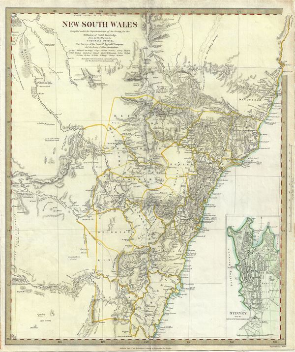
1833 S.D.U.K. Map of New South Wales, Australia
1833 (dated) $200.00
1833 S.D.U.K. Map of New South Wales, Australia
NewSouthWales-sduk-1833$79.50

Title
New South Wales.
1833 (dated) 16 x 13.5 in (40.64 x 34.29 cm) 1 : 1750000
1833 (dated) 16 x 13.5 in (40.64 x 34.29 cm) 1 : 1750000
Description
This is a fascinating 1833 map of New South Wales, Australia, by the S.D.U.K. It covers the eastern Australia from Trial Bay to Bateman Bay. Although the coastlines are accurately mapped, much of the interior remains relatively unknown. Several notes throughout note the speculative inland topography, including 'Level and scrubby stunted Iron bark,' 'Barren rocky hills with some Cypress,' 'Extensive Plains of Red Sand,' etc. An inset in the lower right quadrant of the map details Sydney from the New South Wales Almanac. This map was created based on the surveys of the Australian Agricultural Company and the routes of Allan Cunningham, the noted British explorer and botanist.
Published in 1833 by Baldwin and Cradock of Paternoster Row for the Society for the Diffusion of Useful Knowledge, or S.D.U.K. Although the Society formally closed its doors in 1848, subsequent reissues of the S.D.U.K. atlas were printed well into the 1870s by Chapman and Hall, who acquired the original plates.
Published in 1833 by Baldwin and Cradock of Paternoster Row for the Society for the Diffusion of Useful Knowledge, or S.D.U.K. Although the Society formally closed its doors in 1848, subsequent reissues of the S.D.U.K. atlas were printed well into the 1870s by Chapman and Hall, who acquired the original plates.
Cartographer
The "Society for the Diffusion of Useful Knowledge" (1826 - 1848) was a Whiggish organization founded in 1828 at the instigation of idealistic British lord Henry Peter Brougham. The admirable goal of the Society was to distribute useful information via a series of publications to the English working and middle classes. It promoted self-education and the egalitarian sharing of all knowledge. While closely tied to the London University and publishing houses on the order of Baldwin and Cradock, Chapman and Hall, and Charles Knight, the Society failed to achieve its many lofty goals in finally closed its doors in 1848. Most likely the failure of the Society resulted from its publications being too expensive for its intended lower to middle class markets and yet not large and fine enough to appeal to the aristocratic market. Nonetheless, it did manage to publish several extraordinary atlases of impressive detail and sophistication. Their most prominent atlas consisted of some 200 separately issued maps initially published by Baldwin and Cradock and sold by subscription from 1829 to 1844. Afterwards, the Society combined the maps into a single world atlas published under the Chapman and Hall imprint. In its day, this atlas was unprecedented in its quality, scope, and cost effectiveness. Today Society, or S.D.U.K. as it is commonly known, maps are among the most impressive examples of mid-19th century English mass market cartographic publishing available. The S.D.U.K. is especially known for its beautiful and accurately detailed city plans. More by this mapmaker...
Source
Maps of the Society for the Diffusion of Useful Knowledge, (London: Baldwin & Cradock), 1833.
Condition
Very good. Blank on verso.
References
Rumsey 0890.156. Phillips (Atlases) 794.