1853 Black Map of New South Wales and Victoria, Australia with Gold Deposits
NewSouthWalesVictoria-black-1853$150.00

Title
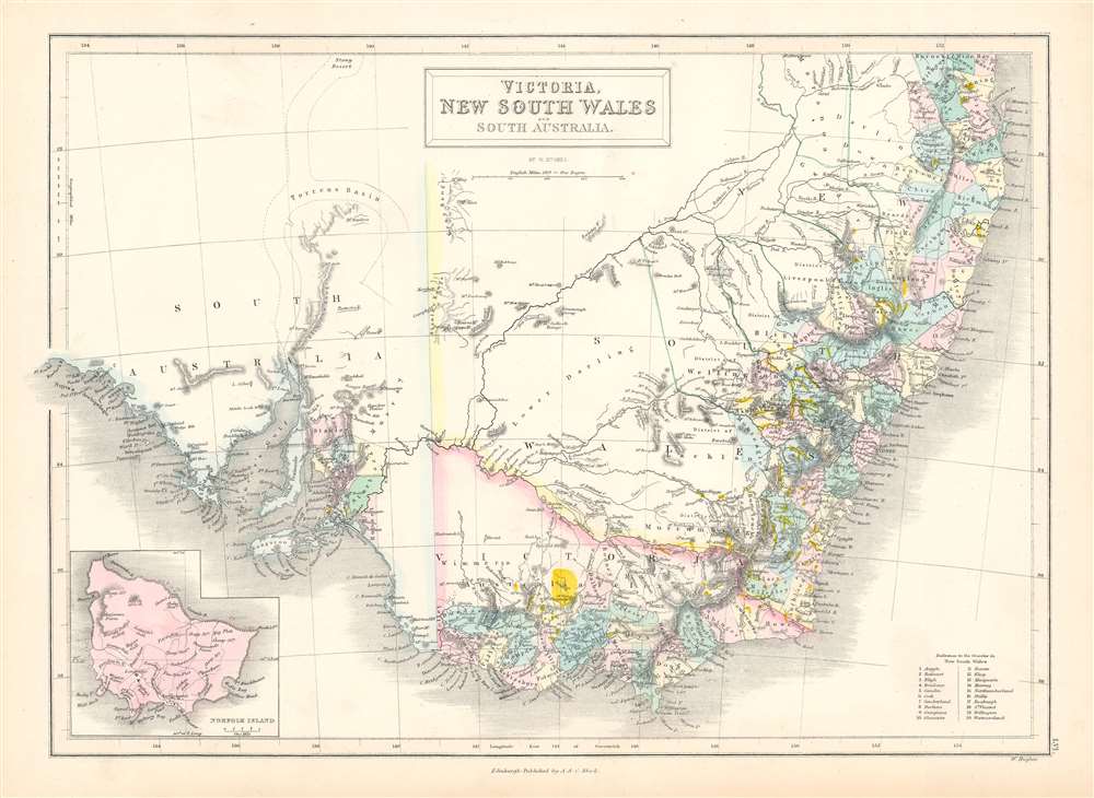
Victoria, New South Wales, and South Australia.
1853 (undated) 11.75 x 16.5 in (29.845 x 41.91 cm) 1 : 4500000
1853 (undated) 11.75 x 16.5 in (29.845 x 41.91 cm) 1 : 4500000
Description
This is an 1853 Adam and Charles Black map of New South Wales, Victoria, and South Australia, Australia. Updated because of intense interest surrounding the Australian Gold Rush, the region's gold deposits are highlighted in yellow. Twenty counties in New South Wales are numerically identified and correspond to a reference situated in the lower right corner. A handful of counties appear in South Australia around Adelaide and St. Vincent Gulf. All these counties are concentrated along the coastline with little inland detail, apart from river network in New South Wales.
Australian Gold Rush of 1851
Gold was known to be present in Australia prior to 1851, but the intentional suppression of this information by the colonial government of New South Wales prevented all-out gold rushes. When gold was discovered at Sutter's Mill, California, in 1848, causing the California Gold Rush, countless Australians migrated in search of their fortunes. Desirous of maintaining their dwindling work force, the colonial governors rethought their position, and sought approval from the Colonial Office in England to allow the exploitation of the mineral resources and also offered rewards for the finding of payable gold. This led to the first major Australian gold rush when prospector Edward Hargraves discovered gold at Ophir, near Orange. A series of subsequent discoveries followed, transforming the Australian economy and leading to a rush of new immigration.Publication History and Census
This map was drawn by William Hughes and published by Adam and Charles Black in the 1853 edition of their Black's General Atlas. The separate map appears in eight institutional collections in OCLC and the atlas is well represented institutionally.CartographerS
Charles and Adam Black (fl. 1807 - present) were map and book publishers based in Edinburgh. Charles and his uncle, Adam, both of Edinburgh, Scotland, founded their publishing firm in 1807. They published a series of maps and atlases throughout the 19th century. In addition to an array of atlases, the Black firm is known for their editions of the Encyclopedia Britannica (1817 - 1826) and the first publishing of Sir Walter Scott's novels in 1854. In 1889 the A. & C. Black publishing house moved to London where it remains in operation to this day. More by this mapmaker...
William Hughes (c. 1818 - May 21, 1876) was a cartographer, engraver, lithographer, printer, and publisher active in London during the middle part of the 19th century. Hughes enjoyed and long and varied cartographic career. He was elected a Fellow of the Royal Geographical Society in 1838 and, from about 1840, taught geography and mapmaking at St. Johns College for Civil Engineers. He later taught the same at both Queens College and Kings College, London. For a time he was employed as a map librarian for the British Museum. Hughes began engraving maps around 1839 and worked with most of the prominent British map and atlas publishers of his era, including but not limited to Charles Knight, A. and C. Black, George Philip, William Cassell, and others. Learn More...
Source
Black, A. and C., Black's General Atlas (Edinburgh), 1853.
Condition
Very good. Even overall toning. Blank on verso.
References
Rumsey 6833.005. OCLC 71472856.