
This item below is out of stock, but another example (left) is available. To view the available item, click "Details."
Details
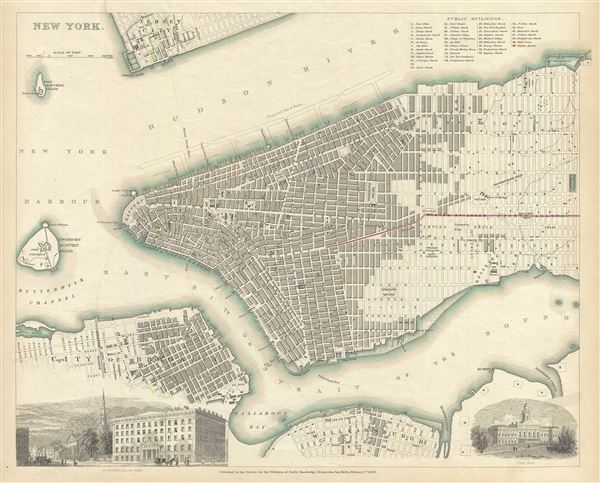
1840 S.D.U.K. Map of New York City
1840 (dated) $500.00
1840 S.D.U.K. Map of New York City
NewYork-sduk-1840$250.00

Title
New York.
1840 (dated) 13 x 16 in (33.02 x 40.64 cm) 1 : 15800
1840 (dated) 13 x 16 in (33.02 x 40.64 cm) 1 : 15800
Description
This is a fine 1840 first edition example of the Society for the Diffusion of Useful Knowledge's city plan or map of New York City. The map coves southern Manhattan from the Battery northwards to 42nd street as well as portions of adjacent Jersey City, Brooklyn, and Williamsburg. Governors Island and Ellis Island appear in the harbor. Massive proposed docks on the Hudson River, none of which actually materialized, as well as tentative landfills on the East Side and in Williamsburg are ghosted in. Shading illustrates the areas of heaviest development in each of the three cities depicted. In Manhattan specifically no less than 40 important buildings are identified numerically and by a key in the upper right quadrant. Several ferry lines are illustrated crossing both the Hudson and East Rivers. Red highlighting indicates railroad lines and tramways. In the lower quadrants engraved views illustrate 'Broadway from the Park,' that being City Hall Park with Trinity Church clearly visible in the background, and City Hall itself. This map was printed for the S.D.U.K. Atlas which was issued in several editions from about 1844 well into to the 1850s.
Cartographer
The "Society for the Diffusion of Useful Knowledge" (1826 - 1848) was a Whiggish organization founded in 1828 at the instigation of idealistic British lord Henry Peter Brougham. The admirable goal of the Society was to distribute useful information via a series of publications to the English working and middle classes. It promoted self-education and the egalitarian sharing of all knowledge. While closely tied to the London University and publishing houses on the order of Baldwin and Cradock, Chapman and Hall, and Charles Knight, the Society failed to achieve its many lofty goals in finally closed its doors in 1848. Most likely the failure of the Society resulted from its publications being too expensive for its intended lower to middle class markets and yet not large and fine enough to appeal to the aristocratic market. Nonetheless, it did manage to publish several extraordinary atlases of impressive detail and sophistication. Their most prominent atlas consisted of some 200 separately issued maps initially published by Baldwin and Cradock and sold by subscription from 1829 to 1844. Afterwards, the Society combined the maps into a single world atlas published under the Chapman and Hall imprint. In its day, this atlas was unprecedented in its quality, scope, and cost effectiveness. Today Society, or S.D.U.K. as it is commonly known, maps are among the most impressive examples of mid-19th century English mass market cartographic publishing available. The S.D.U.K. is especially known for its beautiful and accurately detailed city plans. More by this mapmaker...
Source
Maps of the Society for the Diffusion of Useful Knowledge, Vol. 1, (London: Chapman and Hall) 1844.
Condition
Very good. Minor toning and spotting.
References
Haskell, D., Manhattan Maps A Co-operative List, 840. Map Collectors' Circle, North American city plans, 27. Branch, M.C., An atlas of rare city maps, p. 100-101 (later ed.). Rumsey 0890.192.