This item has been sold, but you can get on the Waitlist to be notified if another example becomes available, or purchase a digital scan.
1851 John Tallis City Plan or Map of New York City
NewYork-tallis-1851$475.00

Title
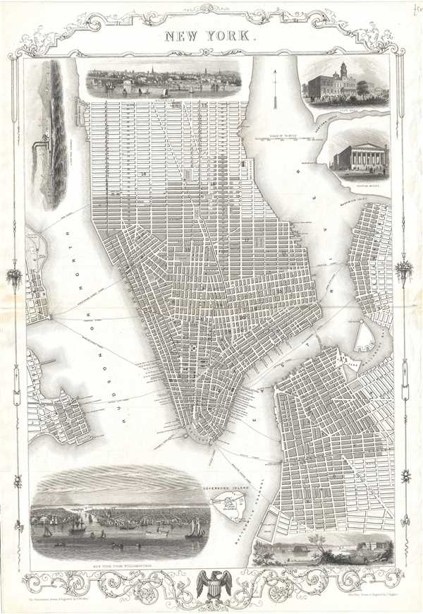
New York.
1851 (undated) 20.5 x 14.5 in (52.07 x 36.83 cm) 1 : 16000
1851 (undated) 20.5 x 14.5 in (52.07 x 36.83 cm) 1 : 16000
Description
This is a beautiful example of John Tallis and John Rapkin’s 1851 decorative map of New York City. Covers the city from the Battery north as far as 42nd Street and includes Governor’s Island and parts of Brooklyn and Jersey City. Notes streets, piers, ferry lines, parks, and important buildings. Six beautifully engraved vignettes adorn the map. These include a view of New York from Williamsburgh, The Narrows from Fort Hamilton, City Hall, Custom House, a view of Brooklyn and a New York Streamer. The map is surrounded by an elaborate decorative border, which includes a coat of arms of the United States.
Tallis's city plans did not appear in all editions of his atlas and so have today become quite rare. Tallis prepared this map for inclusion in R. Montgomery Martin's Illustrated Atlas, And Modern History of The World.
Tallis's city plans did not appear in all editions of his atlas and so have today become quite rare. Tallis prepared this map for inclusion in R. Montgomery Martin's Illustrated Atlas, And Modern History of The World.
Cartographer
John Tallis and Company (1838 - 1851) published views, maps, and atlases in London from roughly 1838 to 1851. Their principal works, expanding upon the earlier maps of John Cary and Aaron Arrowsmith, include an 1838 collection of London Street Views and the 1849 Illustrated Atlas of the World. The firm’s primary engraver was John Rapkin, whose name and decorative vignettes appear on most Tallis maps. Due to the embellishments typical of Rapkin's work, many regard Tallis maps as the last bastion of English decorative cartography in the 19th century. Although most Tallis maps were originally issued uncolored, it was not uncommon for 19th century libraries to commission colorists to "complete" the atlas. The London Printing and Publishing Company of London and New York bought the rights for many Tallis maps in 1850 and continued issuing his Illustrated Atlas of the World until the mid-1850s. Specific Tallis maps later appeared in innumerable mid to late-19th century publications as illustrations and appendices. More by this mapmaker...
Source
Montgomery Martin, R., The Illustrated Atlas, And Modern History Of The World, (London) 1851.
Condition
Very good. Minor toning and wear along original centerfold. Minor edge wear.