This item has been sold, but you can get on the Waitlist to be notified if another example becomes available, or purchase a digital scan.
1782 / 1900 Map of New York City During the American Revolutionary War
NewYork1782-stevens-1900$1,800.00

Title
B. F. . Stevens's Facsimile of the Unpublished British Head Quarters Colored Manuscript Map of New York & Environs (1782) Reproduced from the Original Drawing in the War Office, London.
1782 / 1900 (dated) 53 x 122 in (134.62 x 309.88 cm) 1 : 9800
1782 / 1900 (dated) 53 x 122 in (134.62 x 309.88 cm) 1 : 9800
Description
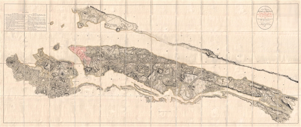
Quite a remarkable discovery of exceptional size, beauty, and rarity. This gigantic Revolutionary War Era map of New York City is the only published facsimile the the great manuscript map of New York City and environs that hung in the British Command Headquarters during the English occupation of New York (1776 – 1783) and which now resides in the London War Office.
Oriented to the west, this map covers all of Manhattan as well as much of adjacent Brooklyn, and parts of New Jersey, Long Island, and the Bronx. It was prepared as a working war manuscript on the orders of British Generals Sir William Howe, Sir Henry Clinton, and Sir Guy Carleton. The map exhibits staggering detail throughout with topography, fields, roads, streams, and apparently even individual trees indicated. Throughout buildings are highlighted in red and fortifications in green. Some important locations, mostly of military interest, are alphanumerically identified and referenced via a table in upper left quadrant.
Following their defeat at the Siege of Boston the British strategy for the remainder of the American Revolutionary War turned on New York City. Their plan was to capture and hold the important port city, using its control of major inland waterways to divide and dominate the continental forces. The subsequent New York Campaign was a disaster for George Washington and the Continental Army, which after a sole victory at the Battle of Harlem Heights, fled into New Jersey where they regrouped. The British meanwhile, as an effort to consolidate their power and hold the city permanently ordered their engineering team to produce this magnificent map of the city. The strategic and tactical advantage of superior cartographic intelligence could not be underestimated and Washington, aware the unassailable British position in New York, turned his strategy elsewhere.
The extreme rarity of this map can be attributed to the fact that Steven's printed 'no more than 100 copies … and the engravings [were] erased as each sheet [was] printed off.' It engraved and printed by Malby and Son and was issued by subscription from Stevens' office at No. 4 Trafalgar Square, London. We have identified several examples in institutional collections including the David Rumsey Collection at Stanford, the Boston Public Library, Columbia University, the New York State Library, the Wisconsin Historical Library, and the Huntington Library. Given Stevens' role as a purchaser for American universities and libraries, it is likely that many of the examples in these venerable collections were acquired directly from Stevens as part of the original subscription. It is unclear how many others have survived.
CartographerS
Benjamin Franklin Stevens (February 19, 1833 – March 5, 1902), was a bibliographer and for about thirty years before his death was the US despatch agent at London. Stevens was born Barnet, Vermont and studied at the University of Vermont, where he was a member of the Sigma Phi society. In the 1840s he joined his more famous brother, Henry Stevens, to London where he worked as a book exporter. He started his own firm in partnership with Henry J. Brown in 1864. The firm operated as B. F. Stevens & Brown Literary and Fine Arts Agents. He spent some 30 years in London preparing and chronological and alphabetical index of American state papers in European archives and issued numerous facsimiles of important American historical documents. In addition, he worked as a purchasing agent for various American libraries. He died at Surbiton, Surrey, England, on the 5 March 1902. He is buried at Kensal Green Cemetery, London More by this mapmaker...
Thomas Malby (fl. 1810 – present) was a prominent British engraver, printer, and globemaker active in in London during the middle to late 19th century and early 20th century. The firm was founded by Thomas Malbyin 1810. Later Thomas's son, Thomas Malby Jr. joined the firm and it was renamed Malby and Son and relocated to Parker Street, London. In time, Thomas Malby Jr. passed the business to his own son, Thomas Malby III. Most of their globes cartographically followed on the maps of the S.D.U.K and were engraved by 'C. Malby,' presumably a relative. After about 1862 Malby seems to have sold all or part of h his globe business to James Wyld, another London cartographer and publisher. In addition to globes, the firm printed for a variety of business raging private publishers of cartography, to patent drawings, to government publications. Malby also published much of B. F. Steven's bibliographical facsimile work relating to his 1889 – 1895 Facsimiles of Manuscripts in European Archives Relating to America, 1773 – 1783. The firm survived two world wars and in a modified from as London Name Plate Manufacturing Co. LTD. They produce signs, plaques, labels, and decals. It is owned by the 7th and 8th generations of the Malby family. Learn More...
Condition
Very good. Dissected and mounted on linen in 48 page large panels. Original linen backing extremely fragile with occasional splits and all stress lines reinforced on verso with archival tissue. Printed map is strong. There is some wear at fold intersections and one or two small closed tears.
References
Rumsey 6403.003. Boston Public Library, G3804.N4:2M3R2 1782 .B24 1900. OCLC 228700434, 79716681, 945084638, 556797901.