
1928 Crosby Pictorial Map of Manhattan, New York City

This item has been sold.
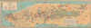
Pictorial Map of New York City Illustrating in graphic manner the Points of Interest: Important Buildings, Institutions, Churches, Parks, Theatres and famous Fifth Avenue Residences.
Secretly maps Prohibition-era speakeasies!
Choose a Collection:
- Digital Map Information
- Suitable for large format printing
- Full resolution TIFF file
- ICC color profile embedded
- Delivered instantly via download link
This Item
Enquire
Secretly maps Prohibition-era speakeasies!
This is Arthur Crosby's 1928 pictorial map of Manhattan, New York City, issued at the height of Prohibition. Despite creating the map for the conservative Chase National Bank, Crosby uses figural silhouettes of animals and objects to highlight some 20 speakeasies in Greenwich Village.Subtly Documenting Speakeasies
Speakeasies proliferated in Greenwich Village throughout Prohibition. Twenty peculiar, unlabeled silhouettes, mostly animals, pepper the West Village - these can only be the Village's famous hopping speakeasies. Most were ephemeral, frequently moving from location to location, and all were illegal. In addition, there may have been some motivation on Crosby's part not to identify exact locations. Nonetheless, there are a few we can put a name to:- Horse - White Horse Tavern
11th and Hudson Streets - Certainly the historic White Horse Tavern. - Pirate - Pirate's Den
12 Gay Street - Must be Don Dickerman's Pirate's Den. - Cat - Chumley's
Corner of Bedford and Barrow Streets - Likely the famous speakeasy Chumley's. Today, there is a modern reincarnation at the same spot! - Cauldron - Jack's
Charles Street between Bleecker and West 4th - Possibly a known local speakeasy. - Eagle - Beatrice Inn
Hudson Street - Former speakeasy turned celebrity hotspot. - Smoking Woman - Greenwich Tavern
Barrow and Commerce Streets - Mentioned in only a few oral accounts. - Teapot - Eve Adams' Tearoom
MacDougal Street - Run by Eva Kotchever, the only known lesbian speakeasy, raided and shut down in 1926. - Ball of Twine - Tony Soma's
Near 6th and Waverly - Most famous Village speakeasy; literary hangout for Hemingway, Parker, and O'Neill. - Witch - Barrow Street Speakeasy
Barrow and Hudson - Little known, but recorded as being raided by Prohibition officers in 1927. - Pig - Blind Pig
West Fourth and Bank Street - 'Blind Pig' was a generic name for speakeasies. - Rat - Unknown
Gansevoort and West Fourth - No known speakeasy by this name, but 'rat holes' often referred to cellar bars (Ratskeller). - Snake - Unknown
Hudson and Charles Street - No documented snake-themed speakeasy. - Owl - Unknown
Hudson and Morton - No known owl-themed speakeasy, but symbolically possible. - Tophat - Unknown
Leroy and Varick - No documented name, but may reference coded dress-based entry. - Rabbit - Unknown
Bank and West Fourth - No known speakeasy on record. - Rabbit II - Unknown
West 11th - Second 'rabbit' location; undocumented. - Pine Tree - Unknown
Charles Street - Possibly symbolic or ephemeral. - Donkey - Unknown
Christopher Street - No known name, but the street had documented speakeasies. - Parrot - Unknown
Bleecker and West 10th - No direct confirmation.
Greenwich Village and the West Village were popular for speakeasies because these neighborhoods had easy access to smuggled alcohol coming up the Hudson River from the Atlantic. It was also reported to be easier for independent operators to gain police protection from organized crime syndicates in Greenwich Village than in other parts of the city.
New York's Most Famous and Infamous Sites
Pictorial illustrations of New York's most well-known sites populate Manhattan, including the Metropolitan Museum of Art, the American Museum of Natural History, Pennsylvania Station (before it was demolished), Trinity Church, Columbia University, and Grand Central Station. Central Park is illustrated in some detail and includes a profile view of the Obelisk (Cleopatra's Needle, carved around 1425 BCE in Heliopolis, Egypt). Hotels, churches, and other monuments are also detailed. Most eye-catching are the Chase National Bank branches, highlighted in red, underscoring the bank's sponsorship of this map. The mansions of the rich and famous line Fifth Avenue, and theatres are noted throughout the Theatre District. At the other extreme is the Tombs, an infamous prison in lower Manhattan. A caricature marks Chinatown. The predominantly Jewish Lower East Side is named 'The Ghetto'.The S.S. Leviathan
The S.S. Leviathan is illustrated at Pier 84 along the Hudson River, one of two 'berths' set aside for her (the other was Pier 86). Leviathan was built as the Vaterland ('Fatherland' in German) and was the second of three sister ships built for transatlantic service for Germany's Hamburg-America Line. She sailed for the Hamburg-American Line for less than a year, making her maiden voyage in May 1914, before being stranded in New York Harbor by World War I (1914 - 1918). She rested at a dock in Hoboken for nearly three years. When the U.S. entered World War I in April 1917, it seized for the war effort and transferred to the U.S. Navy. The Navy renamed her the USS Leviathan. Leviathan made numerous transatlantic voyages during the war and was even painted with British 'dazzle' camouflage. By the end of the war, she had transported over 119,000 men. The USS Leviathan was decommissioned in 1919 and handed over to the U.S. Shipping Board in October of that year. Contemporaneous to this map, Leviathan was refitted as a luxury ocean liner and set out on her maiden voyage in July 1923 with 3,000 passengers. The SS Leviathan traversed the Atlantic numerous times a year until 1931, when, because of the Great Depression, profits dropped off. Once again, Leviathan was relegated to a dock in Hoboken beginning in June 1933 and rested there until 1937, when the British Metal Industries Ltd bought her for scrap.Publication History and Census
This map was created by Arthur Crosby and published for Chase National Bank in 1928. It is cataloged at eight institutions in the OCLC and is also part of the David Rumsey Historical Map Collection.Cartographer
The Arthur Crosby Service Inc. (fl. c. 1921 - c. 1935) was an American publisher operating in New York City. The Arthur Crosby Service published folder, booklets, and general advertising. They specialized in writing advertising for restaurants, hotels, antique dealers, and decorators. Further Details...
Condition
Very good. Light wear along fold lines and top edge.
References
Rumsey 11664.002. OCLC 862978115.