
1843 Nicollet Map of the Upper Mississippi River Watershed

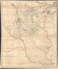
Hydrological Basin of the Upper Mississippi River From Astronomical and Barometrical Observations, Surveys, and Information.
'One of the greatest contributions ever made to American geography' - G. K. Warren
- Digital Map Information
- Suitable for large format printing
- Full resolution TIFF file
- ICC color profile embedded
- Delivered instantly via download link
'One of the greatest contributions ever made to American geography' - G. K. Warren
This is Joseph N. Nicollet's foundational 1843 map of the Upper Mississippi River Basin, which far surpassed all earlier maps of the area. It was the culmination of Nicollet's life's work and four surveying expeditions, which also helped launch the careers of John C. Frémont and William H. Emory, two of the greatest American explorers of the 19th century.A Closer Look
The map covers a wide portion of the Upper Midwest, from Devils Lake (Mini Wakan) and Red Lake in northern Minnesota to St. Louis and the confluence of the Mississippi and Missouri Rivers in the south. The western edge of the map is the vast prairie region of the Dakotas, extending east to Peoria and Madison. Rivers, lakes, and waterways are recorded throughout. Hachures indicate elevation, while light shading denotes the watersheds of the Mississippi River and its many tributaries. Forts, trading posts, Native American villages, and other settlements are marked, as are points where astronomical observations were used to determine elevations. Dashed lines trace 'portages and routes,' including the routes taken by Nicollet's surveying expeditions. Other information is interspersed, including a pronunciation guide for 'Indian names' and the 'country' of different tribes throughout the region.Significance of the Map
This map represents a pivotal moment where cartography of the American continent shifted from speculative art to rigorous science. Unlike his predecessors, who often relied on hearsay or rough sketches, Nicollet utilized a formidable battery of astronomical and barometrical instruments to fix the latitude, longitude, and elevation of over 90,000 points across the American interior. By integrating these precise measurements with detailed observations of the region's topography and drainage systems, he created the first truly modern scientific map of the Upper Midwest.Beyond its technical brilliance, the map served as a foundational document for the U.S. Army Corps of Topographical Engineers (founded 1838) and influenced decades of westward expansion. It accurately identified the Coteau des Prairies and the intricate network of rivers and lakes that feed the Mississippi, correcting long-standing errors in North American geography. Nicollet's work also demonstrated a rare sensitivity to the environment and indigenous knowledge, as he frequently consulted Native American guides to verify place names and seasonal water shifts. Ultimately, his map transformed the Upper Mississippi from a mysterious wilderness into a quantified landscape, setting the standard for all federal mapping projects that followed, including the legendary surveys of the American West. Several of the most important surveys of the American West in the following decades were led by young topographers on Nicollet's team, John C. Frémont (1813 - 1890) and William H. Emory (1811 - 1887). This is Frémont's earliest attribution on a map and among the earliest for Emory.
Publication History and Census
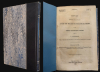
Nicollet and his team of surveyors prepared a map of their discoveries in 1842 to supplement their report, written in 1841. This original 1842 map, on a scale of 1:600000 rather than 1,200,000 as here, was distributed to the Senate directly in a limited run and few, if any, survive. The map was then prepared for publication in 1843, engraved by William J. Stone, and included with a report for the U.S. Senate published by Blair and Rives. The map was included in both House and Senate Reports without changes. Catalog listings tend to comingle digital and physical examples, as well as originals and later reproductions, making a census difficult to establish. We can, however, say with certainty that both the map and report are well-represented institutionally, but are scarce in the market.Cartographers
Joseph Nicolas Nicollet (Jean-Nicolas Nicollet; July 24, 1786 - September 11, 1843) was a French-born American geographer, mathematician, and astronomer best known for mapping the Upper Mississippi River basin. Nicollet was born in Savoy and was recognized as a gifted student, earning a scholarship to the Jesuit college at Chambéry. He was a math prodigy, already teaching the subject to others at age 19. In 1817, he was recruited to work with Pierre-Simon Laplace and teach at the Observatoire de Paris. Soon afterwards, he also began teaching at the Collège Louis-le-Grand. Following the 1830 July Revolution, Nicollet ran into financial trouble and professional roadblocks, motivating him to move to the United States in 1832, already harboring a goal to map the Upper Mississippi. These efforts were delayed by a cholera outbreak, but Nicollet finally reached St. Louis in 1835 and quickly gained the financial support of the American Fur Company and the wealthy French-descended Choteau family, which had helped found St. Louis. With this critical backing, Nicollet spent the next four years leading three expeditions through the Upper Mississippi region. Members of his surveying teams included John C. Fremont and William H. Emory, who would go on to become two of the most important 19th century American cartographers. In September 1839, Nicollet traveled to Washington, D.C. to write up a report of his expeditions as a Congressional report. He planned to return to conduct further expeditions, but was unable to due to poor health and he died in Washington in 1843, after which he was buried in the Congressional Cemetery, a mark of how highly regarded his important work was at the time. The publication of Nicollet's report and maps were essential in promoting the understanding of the region's topography and peoples. His journals, later published, also made many detailed notes on the Native American groups he encountered. Further Details...
John Charles Frémont (January 21, 1813 - July 13, 1890) was an American military officer, politician, and explorer. Fremont was born in Savannah, Georgia. A man of adventure, Frémont led several expeditions into the American West in the 1840s, earning the nickname 'The Pathfinder.' His explorations, documented in reports and maps, significantly contributed to the understanding of the western United States and were instrumental in guiding settlers to the region. Frémont's military career was marked by his role in the Bear Flag Revolt (June 1846), leading to the annexation of California as part of the United States. In politics, he was a prominent figure in the early Republican Party and was its first presidential candidate in 1856, though he was unsuccessful in his bid. His later life was marred by controversy and financial troubles, but his early contributions to the exploration and expansion of the American West cemented his place in U.S. history. He died in 1890 in New York City. Further Details...
John James Abert (September 17, 1788 - January 27, 1863) was an American soldier and engineer. For most of his career he was head of the United States' Corps of Topographical Engineers, initially an arm of the Corps of Engineers. In this role he was instrumental in organizing the mapping of the growing nation. He was born in Shepherdstown, Virginia; His father, John Abert, was reputed to have been a soldier in the company of the comte de Rochambeau, arriving to fight on behalf of the Americans in 1780. Despite having graduated from West Point, he initially intended to practice law. The war of 1812 saw him joining the D.C. Militia, however, and by 1814 he had enlisted as a topographical engineer. His bravery at the Battle of Bladensburg led to his brevetting to the rank of Major. In 1838 he was promoted to Colonel and appointed to lead the Corps of Topographical Engineers, having persuaded Congress to establish a separate Topographical Corps, distinct from the Corps of Engineers. This was primarily tasked with the mapping of the Transmississippi West. He remained at the head of the Corps for 23 years; Recognition for his labors led to his election as member of the American Philosophical Society and an Associate Fellow of the American Academy of Arts and Sciences. He retired in 1861 and died in 1863 in Washington, D.C. Further Details...
William Hemsley Emory (September 7, 1811 - December 1, 1887) was an American surveyor, civil engineer, and Army officer. Born in Queen Anne's County, Maryland, Emory graduated from the United States Military Academy at West Point in 1831, was assigned to the Fourth Artillery, and resigned from service in 1836 to pursue civil engineering. He returned to the army in 1838 to serve in the newly-formed Army Corps of Topographical Engineers. During the Mexican-American War, Emory served in the Army of the West under the command command of Stephen Watts Kearny. While serving with Kearny, he kept a detailed journal that was then published as Notes of a Military Reconnaissance from Fort Leavenworth to San Diego and soon became an important guidebook for the route to Southern California. After the war, Emory served as part of the team that surveyed the United States-Mexican border. When the American Civil War started, Emory was stationed in Indian Territory and immediately realized the likelihood that Confederates would capture him and his men. To avoid this, Emory quickly secured the services of Black Beaver, the famous Lenape warrior, to guide them out of the territory. Emory and his troops, on their way from Fort Washita to Fort Leavenworth, captured a number of their Confederate pursuers, which were the first prisoners taken during the war. Emory then served in the Army of the Potomac, in the Western Theater, and in the Shenandoah Valley Campaign of 1854. After the war, Emory held the post of commander of the Department of the Gulf during Reconstruction and, in September 1874, President Ulysses S. Grant ordered Emory to New Orleans, where he successfully negotiated a peace with the white supremacist paramilitary organization the White League, which led to the White League being disbanded. Emory married Matilda Wilkins Bache on May 29, 1838 in Philadelphia, with whom he had two sons, both of which served in the United States armed forces. Matilda Bache was Alexander D. Bache's sister. Alexander Bache was one of the most influential superintendents of the United States Coast Survey. Further Details...
William James Stone (c. 1800 - 1865) was an English-born American engraver, lithographer, and sculptor based in Washington D.C. Stone emigrated to the United States in 1804 where he studied engraving under Peter Maverick (1780 - 1831) in New York. Stone started his firm in Washington D.C. in 1815 where he capitalized on the printing of government maps and documents. His most significant accomplishment is his 1823 facsimile of the Declaration of Independence – probably the most exact and iconic version of that document ever printed. Stone is said to have worked three years on his copy of the Declaration of Independence. Among his cartographic works are Emory's map of Texas and Graham's 1836 map of Provincetown. Stone retired from printing to pursue sculpture in the 1840s. He died in 1865. Further Details...
Source
Nicollet, J. N., Report intended to illustrate a map of the hydrographical basin of the upper Mississippi river 26th Congress, 2d Session., (Washington, D.C.: Blair and Rives) 1843.
Condition
Good. Archival verso stabilization of old fold intersections at various points. Even toning. Slight transference. Fill repair upper right border.
References
Rumsey 2488.001. OCLC 5502096 et al. Sabin 55257; Streeter Sale 1808; Wagner-Camp 98; Schwartz and Ehrenberg, p. 265-68. Jackson, D. and Spence, M. (eds.), The expeditions of John Charles Frémont, Vol. 1, (University of Illinois Press) 1970. Bray, M., Joseph Nicollet and His Map, (Center for Western Studies) 2008.