This item has been sold, but you can get on the Waitlist to be notified if another example becomes available, or purchase a digital scan.
1835 David Burr Map of New York City
NewYorkCity-burr-1836$562.50

Title
Map of New-York
1835 (undated) 17.5 x 22.5 in (44.45 x 57.15 cm)
1835 (undated) 17.5 x 22.5 in (44.45 x 57.15 cm)
Description
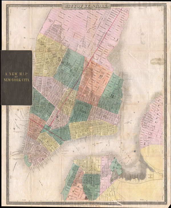
This is the c. 1834-1836 edition of David H. Burr and Edward Walker's important pocket map of the City of New York. Covers New York City south of 26th street on the west side and south of 40th street on the east side. Shows the city in considerable detail with attention to churches, theaters, ferries, government buildings, museums, and other public centers. Columbia College is noted on Murray Street. Also notes the Fulton Fish Market, St. Marks Church in the East Village and the nation's first hospital at Bellevue. This map includes parts of Brooklyn and Williamsburg, which, at the time, were separate cities. The proposed landfill in the East River just south of Bellevue is projected, but would remain incomplete for several years following the issue of this map. Burr issued this map in various states from 1834 to 1845 in conjunction with two separate publishers, Edward Walker (114 Fulton Street) and J. H. Colton (172 William Street). The Colton variants are sometimes dated, but Walker did not put a date stamp on his issues, thus making this map very difficult to date with precision. What we do know is that later issues contained a legend in the lower left hand quadrant which ours does not, marking it as an earlier variant. Engraved by S. Stiles of Wall Street, New York. Book library stamp reads 'Hermon Stevens.' This could either refer to one Hermon Stevens who was a lawyer in Rockland Maine during the mid 19th century or another Hermon Stevens who lived in St. Lawrence County New York in 1865.
Cartographer
David Hugh Burr (August 18, 1803 - December 25, 1875) of one of the first and most important truly American cartographers and map publishers. Burr was born in Bridgeport Connecticut in August of 1803. In 1822 Burr moved to Kingsboro, New York to study law. A year and a half later he was admitted to the New York Bar association. Burr must have questioned his choice of careers because shortly after being admitted to the Bar, he joined the New York State Militia. Though largely untrained in the art of surveying, Burr was assigned to work under Surveyor General of New York, Simeon De Witt, to survey several New York Roadways. Seeing a window of opportunity, Burr was able to negotiate with the governor of New York at the time, De Witt Clinton, to obtain copies of other New York survey work in order to compile a map and Atlas of the state of New York. Recognizing the need for quality survey work of its territory, the government of New York heartily endorsed and financed Burr's efforts. The resulting 1829 Atlas of the State of New York was the second atlas of an individual U.S. state and one of the most important state atlases ever produced. Burr went on to issue other maps both of New York and of the United States in general. In cooperation with publishing firm of Illman & Pillbrow, he produced an important New Universal Atlas and, with J.H. Colton, several very important maps of New York City. In recognition of this work, Burr was appointed both "Topographer to the Post office" and "Geographer to the House of Representatives of the United States". Later, in 1855, Burr was assigned to the newly created position of Surveyor General to the State of Utah. Burr retired from the position and from cartographic work in general in 1857 when light of some of his financial misdeeds and frauds came to light. He was accused of submitting false expense reports and underpaying employees, among other indiscretions. More by this mapmaker...
Condition
Very good condition. Original folds. Minor verso repairs and reinforcement to some folds, and minor pinhole wear at some fold intersections. Minor printing error, bottom center, in Brooklyn. Removed from original binder, which is included. Transference from library stamp on verso, upper right quadrant. Original hand color. Stored flat.
References
New York Public Library Map Division: 01-1829, 01-1796, 01-1794, 01-1830, 98-747. Haskell, D. C., Manhattan Maps; A Cooperative List, 758 - 759. Phillips, P. L., A List of Maps of America in the Library of Congress, p. 531.