This item has been sold, but you can get on the Waitlist to be notified if another example becomes available, or purchase a digital scan.
1832 Plan or Map of New York City: Manhattan, Brooklyn, Queens
NewYorkCity-marshall-1832$225.00

Title
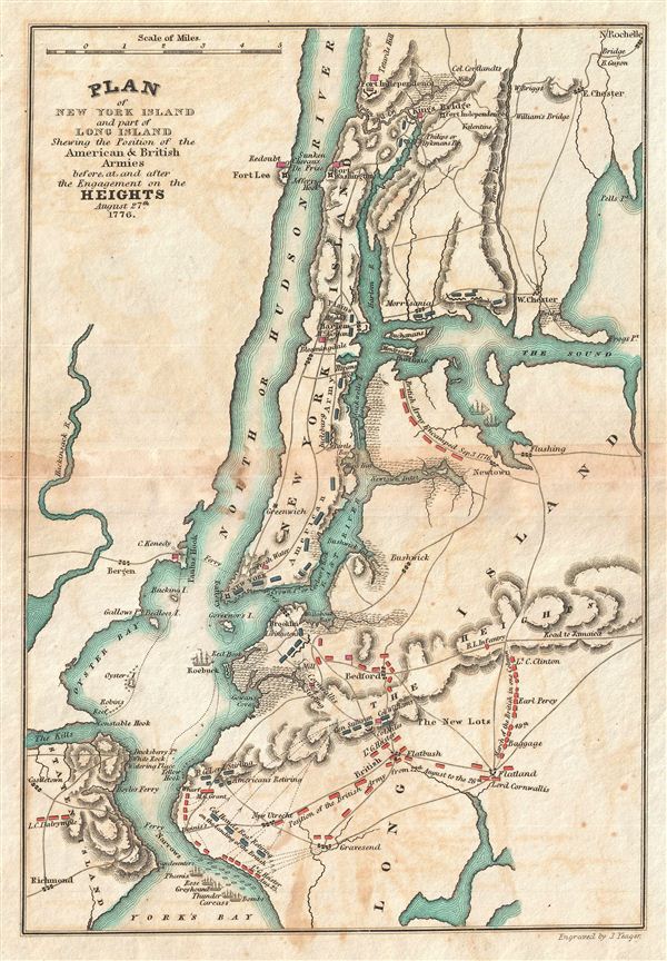
Plan of New York Island and part of Long Island Shewing the Position of the American & British Armies before, at, and after the Engagement on the Heights August 27th 1776.
1832 (undated) 10 x 7 in (25.4 x 17.78 cm)
1832 (undated) 10 x 7 in (25.4 x 17.78 cm)
Description
This is a rare map of New York City during the American Revolutionary War issued for John Marshall's 1832 edition of the Life of Washington. The map covers the strategically important Manhattan Island and vicinity, including Staten Island, Brooklyn, Queens, and the Bronx. Various rivers, roads, and topographical elements are noted. Color coding indicates the positions of the British (Red) and Continental (Blue) forces as each attempted to maintain control of the region.
Marshall prepared this map to illustrate the events leading to the British takeover of New York City and vicinity. Specifically, it details the Battle of Harlem Heights and the Battle of Long Island. In 1776 the British General William Howe, fleeing Boston, regrouped and landed his forces on Long Island and Staten Island. After defeating George Washington at the Battle of Long Island, Howe sized control of New York City and most of Manhattan. A series of subsequent skirmishes culminated in the Battle of Harlem Heights, in what is now Morningside Heights, New York City. Washington controlled the highlands and galvanized his troops to a strong defense, holding the heights against superior British numbers and firepower. Nonetheless, the position proved untenable and Washington and his forces retreated northward to Westchester County. Howe, keen to size the advantage, landed troops in Westchester, a flanking maneuver intending to encircle Washington's forces. Washington, alerted to the tactic entrenched himself in White Plains, but was unable to hold against Howe's. Howe proceeded to drive Washington across New Jersey into Pennsylvania where he famously crossed the Delaware on December 26th to surprise a Brigade of Hessian mercenaries in the Battle of Trenton – a strategic Continental victory and major turning point in the war.
This map appeared in atlas volume attached to the 1832 edition of John Marshall's seminal work, The Life of Washington. Marshall composed the five volume biography between 1805 and 1807 and based the work on original papers and records provided by the president's own family. The earliest partial edition of the The Life of Washington appeared in 1824 as A History of the American Colonies. In 1832 Marshall revised and abridged the original voluminous work to just two volumes and some 400 pages – from which this map was extracted. The maps of the 1832 edition are notable and desirable in that, unlike the original edition, most had hand applied color work.
CartographerS
John Marshall (September 24, 1755 - July 6, 1835) was the longest-serving Chief Justice of the United States (1801-35). Marshall's court opinions helped establish the basis for American constitutional law and made the Supreme Court of the United States a coequal branch of government along with the legislative and executive branches. Previously, Marshall had been a leader of the Federalist Party in Virginia and served in the United States House of Representatives from 1799 to 1800. He was Secretary of State under President John Adams from 1800 to 1801. Between 1805 and 1807 Marshall published an influential five-volume biography of George Washington. Marshall's Life of Washington was based on records and papers provided to him by the late president's family. The work reflected Marshall's Federalist principles, and is frequently praised by historians for its accuracy and well-reasoned judgments. More by this mapmaker...
Joseph Yeager (1792 - 1859) was a Philadelphia based engraver active in the first half of the 19th century. Yeager was trained early on as an engraver with works appearing as early as 1808 and 1809, at just 16 years of age. By the time he reached adulthood, Yeager had become one of the top engravers in Philadelphia, where he maintained offices from 1816 to 1845. He is responsible for numerous maps and views including the map plates for Carey and Lea's American Atlas and the map plates for the 1832 edition of John Marshall's Life of Washington, and a stunning illustration of the Battle of New Orleans. Yeager also published numerous children's books and, in time, became the president of a railroad. Learn More...
Source
Marshall, J., Atlas to Marshall's Life of Washington, (J. Crissy, Philadelphia) 1832.
Condition
Very good. Offsetting. Original centerfold exhibits light toning. Blank on verso.
References
Rumsey 2559.002 (1807 edition). Howes, W., U.S.iana (1650-1950): A Selective Bibliography in which are Described 11,620 Uncommon and Siginficant Books Relating to the Continental Portion of the United States, M317.