This item has been sold, but you can get on the Waitlist to be notified if another example becomes available, or purchase a digital scan.
1846 Mitchell Map of New York City
NewYorkCity-mitchell-1846-3$275.00

Title
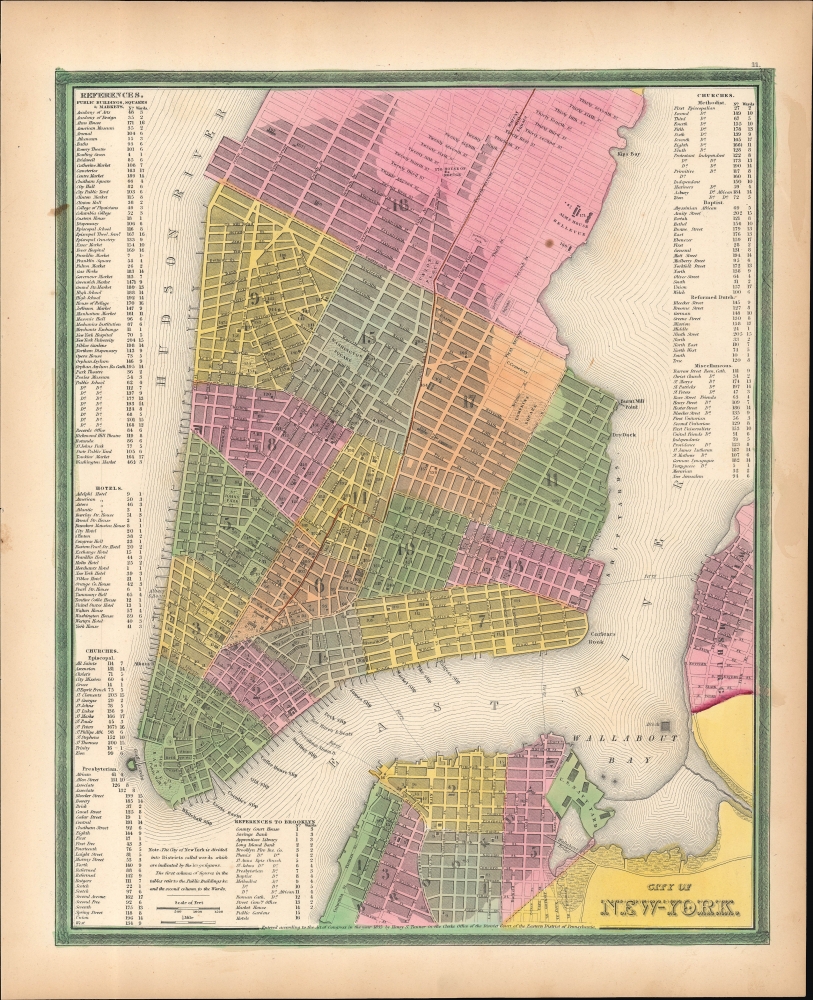
City of New York.
1846 (undated) 15 x 12.25 in (38.1 x 31.115 cm) 1 : 16500
1846 (undated) 15 x 12.25 in (38.1 x 31.115 cm) 1 : 16500
Description
This is Samuel Augustus Mitchell's vibrantly hand-colored 1846 map of New York City. It reflects the city in a period of rapid development, defined by immigration and industrialization.
Notable sites including government offices, churches, cemeteries, schools, markets, squares, museums, banks, and theaters are numbered on the map, corresponding to indexes at left, right, and bottom. Individual streets, parks, piers, and ferry lines are noted on the map itself, as are the Bellevue Alms House (future Bellevue Hospital), House of Refuge (an early juvenile detention and reform center), Castle Garden (Castle Clinton), and the U.S. Navy Yard in Brooklyn.
The red line running down 4th Avenue (now Park Avenue) into the Bowery and then to City Hall represents Harlem Railroad (New York and Harlem Railroad), the world's first streetcar. Initially, the cars were pulled by horses, a practice that would continue in many cities until the late 19th century, but starting in 1837 these were replaced by steam engines, to the great annoyance of residents along the route.
A Closer Look
Coverage extends from what is now southern Manhattan from 37th Street (Kips Bay) south to Battery Park and Brooklyn from Williamsburg to Columbia St. in Brooklyn Heights, with wards of the city color coded with red, green, and yellow pastels. Dark shading represents heavily settled parts of the city, whereas unshaded areas (mostly on the east side of Manhattan above 14th St.) were more sparsely settled.Notable sites including government offices, churches, cemeteries, schools, markets, squares, museums, banks, and theaters are numbered on the map, corresponding to indexes at left, right, and bottom. Individual streets, parks, piers, and ferry lines are noted on the map itself, as are the Bellevue Alms House (future Bellevue Hospital), House of Refuge (an early juvenile detention and reform center), Castle Garden (Castle Clinton), and the U.S. Navy Yard in Brooklyn.
The red line running down 4th Avenue (now Park Avenue) into the Bowery and then to City Hall represents Harlem Railroad (New York and Harlem Railroad), the world's first streetcar. Initially, the cars were pulled by horses, a practice that would continue in many cities until the late 19th century, but starting in 1837 these were replaced by steam engines, to the great annoyance of residents along the route.
Publication History and Census
Though the copyright below the map refences Henry S. Tanner and is dated 1836, this map in fact appeared in the first issue of the first edition of Samuel Augustus Mitchell's New Universal Atlas. Mitchell had acquired the rights to the atlas from Cary and Hart in 1846, who had acquired them from Tanner in 1843. Importantly, in the course of changing hands, the atlas was converted from engraved plates to lithographic prints. Mitchell issued the atlas in early 1846 with Tanner's name still on the maps, then re-issued it later that same year to reflect territorial changes (the addition of Texas to the Union), removing Tanner's name from the copyright and replacing it with Horatio Nelson Burroughs.CartographerS
Samuel Augustus Mitchell (March 20, 1792 - December 20, 1868) began his map publishing career in the early 1830s. Mitchell was born in Bristol, Connecticut. He relocated to Philadelphia in 1821. Having worked as a school teacher and a geographical writer, Mitchell was frustrated with the low quality and inaccuracy of school texts of the period. His first maps were an attempt to rectify this problem. In the next 20 years Mitchell would become the most prominent American map publisher of the mid-19th century. Mitchell worked with prominent engravers J. H. Young, H. S. Tanner, and H. N. Burroughs before attaining the full copyright on his maps in 1847. In 1849 Mitchell either partnered with or sold his plates to Thomas, Cowperthwait and Company who continued to publish the Mitchell's Universal Atlas. By about 1856 most of the Mitchell plates and copyrights were acquired by Charles Desilver who continued to publish the maps, many with modified borders and color schemes, until Mitchell's son, Samuel Augustus Mitchell Junior, entered the picture. In 1859, S.A. Mitchell Jr. purchased most of the plates back from Desilver and introduced his own floral motif border. From 1860 on, he published his own editions of the New General Atlas. The younger Mitchell became as prominent as his father, publishing maps and atlases until 1887, when most of the copyrights were again sold and the Mitchell firm closed its doors for the final time. More by this mapmaker...
Henry Schenck Tanner (1786 - May 18, 1858) was one of the preeminent American map engravers and publishers of the early 19th century - what is considered to be the "Golden Age of American Map Publishing". Born in New York City but based in Philadelphia, Tanner's forty plus year career was almost entirely focused on cartographic work. His earliest map work appears in conjunction with another important map publisher, John Melish. Early in his career, Tanner partnered with his brother Benjamin, to engrave extensively for Melish as well as other Philadelphia publishers including Lucas Fielding (Baltimore), A. Bourne, Jason Torey, Samuel Harrison, and Samuel Lewis, among others. In 1818 Tanner convinced his fellow publishers and partners to finance the compilation of a New American Atlas. The atlas was sold by subscription and slowly emerged between 1819 and 1823. The New American Atlas, possibly the pinnacle of 19th century American cartography and was commended in its day as "one of the most splendid works of the kind ever executed in this country". It was subsequently republished in several updated editions until about 1839. Tanner had by this time become the most active and influential map publisher in the United States. Around 1832, recognizing the market for a less cost prohibitive atlas, Tanner began work on the smaller format New Universal Atlas. This popular and important atlas went through numerous editions before being bought out by Carey and Hart, and then, in 1846, by S. A. Mitchell, who would rise to become the preeminent publisher of the next generation. In addition to these important atlases, Tanner also issued numerous extremely important and influential travelers guides, state maps, wall maps, and pocket maps. He should not be confused with his brother, also an America map engraver, the New Yorker Benjamin Tanner. Learn More...
Source
Mitchell, S.A., A New Universal Atlas Containing Maps of the various Empires, Kingdoms, States, and Republics of the World…, (Philadelphia: Mitchell) 1846.
The New Universal Atlas is one of the great American atlases of the mid-19th century. Samuel Augustus Mitchell first issued the atlas in 1846 when he acquired the map plates and copyright for Tanner's New Universal Atlas from its publisher, Carey and Hart. The first transitional 1846 edition was published jointly with Carey and Hart, but a second edition was published in the same year with the Tanner imprint erased. This edition of the atlas also introduced the signature S. A. Mitchell green and pink color scheme. Most of the maps from the early editions of the atlas were engraved by H. N. Burroughs or C. S. Williams, often bearing their copyright. Burroughs maps also tended to have what map collector David Rumsey refers to as the 'Cary and Hart' borders, which featured a narrow vine motif. These borders were replaced, along with the Burroughs imprint, with the more traditional Mitchell strap work border used in the atlases until 1856. Mitchell published editions until late in 1850, when he sold the rights to Thomas, Cowperthwait and Company of Philadelphia. Under Cowperthwait, the atlases continued to be published and bear the Mitchell name until 1856, when the plates were again sold, this time to Charles Desilver. Desilver reworked the plates with new border art and a revised color scheme in the style of J. H. Colton. Desilver issued editions from 1857 to 1860, when the atlas was phased out in favor of Samuel Augustus Mitchell Jr.'s New General Atlas.
Condition
Very good. Light soiling.
References
Rumsey 0537.012 (1846 Second Issue). Phillips (Atlases) 6103-11.