1866 Mitchell City Plan or Map of New York City, New York
NewYorkCity-mitchell-1867$250.00

Title
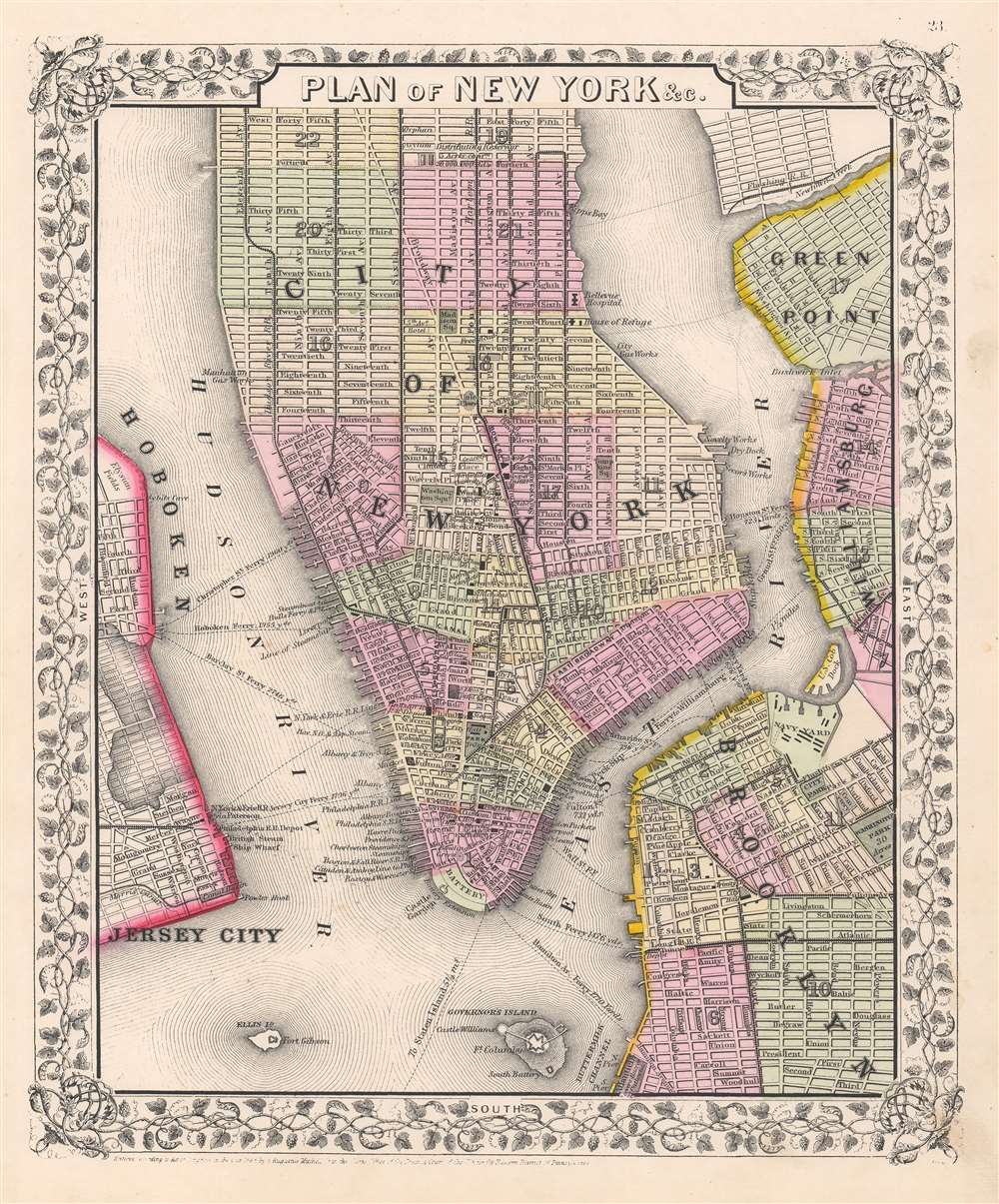
Plan of New York etc.
1867 (dated) 13 x 10.75 in (33.02 x 27.305 cm) 1 : 31300
1867 (dated) 13 x 10.75 in (33.02 x 27.305 cm) 1 : 31300
Description
This is an eye-catching example of Samuel Augustus Mitchell Jr.'s 1866 city plan or map of New York City depicting Manhattan below 45th street. Surrounding lower Manhattan are the noted riverine features of the Hudson River, East River, New York Harbor, Buttermilk Channel, Newtown Creek, and Bushwick Inlet. Adjoining to the borders of the map are parts of Brooklyn, Williamsburg, Greenpoint, Hoboken, and Jersey City. The surrounding neighborhoods and water features draw the viewer's eye into Lower Manhattan from a bygone era. Mitchell offers wonderful detail, referencing parks, streets, piers, railroads, ferries, and important buildings. A few noteworthy features represented in this piece are Ellis Island, Governor's Island, and what is now Battery Park, all of which have since undergone significant geomorphic changes. Within the boroughs of New York City, neighborhoods are color coded with red, green, and yellow pastels according to political divisions. The map is surrounded by an attractive floral border common to Mitchell's atlases between 1860 and 1866. This is a wonderful representation of one of the more attractive atlas maps of New York City to appear in the mid-19th century.
Publication History
Prepared by S. A. Mitchell Jr. for inclusion as plate 19 in the 1867 issue of Mitchell's New General Atlas. Like many American map publishers of this period, Mitchell did not regularly update his copyright, consequently this map is dated and copyrighted to 1860: 'Entered according to Act of Congress in the Year 1860 by S. Augustus Mitchell Jr. in the Clerk's Office of the District Court of the U.S. for the Eastern District of Pennsylvania.'Cartographer
Samuel Augustus Mitchell (March 20, 1792 - December 20, 1868) began his map publishing career in the early 1830s. Mitchell was born in Bristol, Connecticut. He relocated to Philadelphia in 1821. Having worked as a school teacher and a geographical writer, Mitchell was frustrated with the low quality and inaccuracy of school texts of the period. His first maps were an attempt to rectify this problem. In the next 20 years Mitchell would become the most prominent American map publisher of the mid-19th century. Mitchell worked with prominent engravers J. H. Young, H. S. Tanner, and H. N. Burroughs before attaining the full copyright on his maps in 1847. In 1849 Mitchell either partnered with or sold his plates to Thomas, Cowperthwait and Company who continued to publish the Mitchell's Universal Atlas. By about 1856 most of the Mitchell plates and copyrights were acquired by Charles Desilver who continued to publish the maps, many with modified borders and color schemes, until Mitchell's son, Samuel Augustus Mitchell Junior, entered the picture. In 1859, S.A. Mitchell Jr. purchased most of the plates back from Desilver and introduced his own floral motif border. From 1860 on, he published his own editions of the New General Atlas. The younger Mitchell became as prominent as his father, publishing maps and atlases until 1887, when most of the copyrights were again sold and the Mitchell firm closed its doors for the final time. More by this mapmaker...
Source
Mitchell Jr., S. A., Mitchell's New General Atlas, Containing Maps Of The Various Countries Of The World, Plans Of Cities, Etc. Embraced In Fifty-Eight Quarto Maps, Forming A Series Of Ninety-Two Maps And Plans, Together With Valuable Statistical Tables, 1867.
Mitchell's New General Atlas was published by Samuel Augustus Mitchell, Jr., the son of the prolific cartographer Samuel Augustus Mitchell. Many of the plates are derived from the his father's Mitchell's Universal Atlas, but not directly. The Mitchell's Universal Atlas was initially sold to Thomas, Cowperthwait, and Company in 1849, and again to Charles Deliver in 1856. It was Deliver who introduced the new vibrant color scheme, abandoning the older Mitchell's Universal Atlas green borders and themes for bright reds, blues, and yellows. Samuel Augustus Mitchell, Jr. acquired the Deliver plates in 1859. He added his own floral motif border, but doubled down on the vibrant color scheme, thus introducing to the American public the most vividly colored American atlas of the 19th century. In 1860, he published the first edition of his New General Atlas and, despite a slump in sales during the American Civil War, attained a level of success to rival his father. Mitchell would continue to publish the New General Atlas until 1887, when the firm formally closed.
Condition
Very good.
References
Rumsey 0565.010. Phillips (Atlases) 831-16. New York Public Library, Map Division, Digital ID: 1510801. Haskell, D., Manhattan Maps: A Co-operative List, 1104, 1105.