This item has been sold, but you can get on the Waitlist to be notified if another example becomes available, or purchase a digital scan.
1882 Mitchell Map of New York City, New York
NewYorkCity-mitchell-1882$112.50

Title
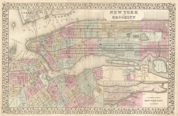
New York and Brooklyn.
1882 (dated) 14 x 21.5 in (35.56 x 54.61 cm)
1882 (dated) 14 x 21.5 in (35.56 x 54.61 cm)
Description
This beautiful hand colored map is a lithographic engraving of New York City, dating to 1882, by the legendary American map publisher S.A. Mitchell, Junior. Covers all of Manhattan and much of Brooklyn as well as adjacent parts of Jersey City and Queens. Includes in inset map of northern Manhattan and parts of Queens in the lower right quadrant. Superb detail at the street level including the indication of individual buildings. The Brooklyn Bridge, still one year away from its 1883 completion, is indicated. Also names the various ferry routes between New York and Jersey City, as well as between Manhattan and Brooklyn. Central Park shown in its completed state. Dated and copyrighted 'Entered according to Act of Congress in the year 1882 by S. Augustus Mitchell in the Office of the Librarian of Congress at Washington.'
Cartographer
Samuel Augustus Mitchell (March 20, 1792 - December 20, 1868) began his map publishing career in the early 1830s. Mitchell was born in Bristol, Connecticut. He relocated to Philadelphia in 1821. Having worked as a school teacher and a geographical writer, Mitchell was frustrated with the low quality and inaccuracy of school texts of the period. His first maps were an attempt to rectify this problem. In the next 20 years Mitchell would become the most prominent American map publisher of the mid-19th century. Mitchell worked with prominent engravers J. H. Young, H. S. Tanner, and H. N. Burroughs before attaining the full copyright on his maps in 1847. In 1849 Mitchell either partnered with or sold his plates to Thomas, Cowperthwait and Company who continued to publish the Mitchell's Universal Atlas. By about 1856 most of the Mitchell plates and copyrights were acquired by Charles Desilver who continued to publish the maps, many with modified borders and color schemes, until Mitchell's son, Samuel Augustus Mitchell Junior, entered the picture. In 1859, S.A. Mitchell Jr. purchased most of the plates back from Desilver and introduced his own floral motif border. From 1860 on, he published his own editions of the New General Atlas. The younger Mitchell became as prominent as his father, publishing maps and atlases until 1887, when most of the copyrights were again sold and the Mitchell firm closed its doors for the final time. More by this mapmaker...
Source
Mitchell Jr., S. A., Mitchell's New General Atlas, containing Maps of the Various Countries of the World Plans of Cities, Etc. Embraced in Ninety-Three Quarto Maps. Forming a series of One Hundred and Forty-Seven Maps and Plans. Together with Valuable Statistical Tables. (Philadelphia) 1882.
Condition
Very good condition. Minor verso reinforcement on original centerfold. Blank on verso. centerfold. Even overall toing.
References
Rumsey 0586.016. Haskel, D. C., Manhattan Maps, A Co-operative List, 1230.