1930 Rand McNally Indexed Folding Map of New York City
NewYorkCity-randmcnally-1929$450.00

Title
Into the heart of New York City by train and motor coach.
1929 (undated) 24 x 14.5 in (60.96 x 36.83 cm) 1 : 14500
1929 (undated) 24 x 14.5 in (60.96 x 36.83 cm) 1 : 14500
Description
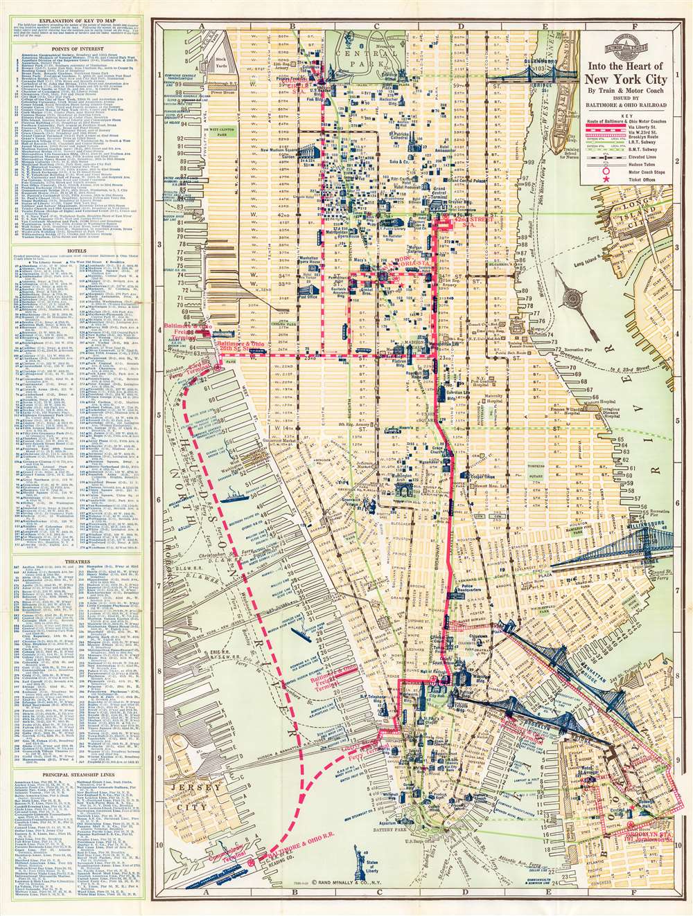
An impressive c. 1929 indexed folding map of New York City, detailing downtown and midtown Manhattan with portions of Brooklyn, Queens, and New Jersey. It was issued by Rand McNally for the Baltimore and Ohio Railroad. Although published in the 'golden age of rail' in the United States, it hints at the eventual triumph of automobiles.
Several features on this map give a sense of its date, particularly the tunnels and subway lines (or lack thereof). When this map was published, the Holland Tunnel had recently been opened, seen here as the New York - New Jersey Vehicular Tunnel (Lincoln Tunnel was not opened until 1934 and the Queens Midtown Tunnel not until 1940). At this time, the subway system was divided between the Interborough Rapid Transit Company (I.R.T.) and Brooklyn–Manhattan Transit Corporation (B.M.T.). In 1932, the 'Independent' City-Owned Subway opened with the Eighth Avenue Line. In 1940, all these lines would be merged under the ownership and management of the city, reorganized under the New York City Transit Authority in 1953, which itself was placed under the administration of the Metropolitan Transportation Authority in 1968.
Meanwhile, the elevated trains in Manhattan along First, Second, Third, Sixth, and Ninth Avenue were gradually eliminated, with the last service ending in 1955. The southern portion of the New York Central Railroad line along Ninth and Tenth Avenues noted here was used for freight but with decreasing frequency. After sitting dormant for years, it was reopened as the acclaimed High Line park in 2009.
Although a necessary accommodation to their lack of tunnel rights, the B and O's embrace of motor coaches, in retrospect, also signaled the rise of automobiles and the decline of intercity passenger rail in the U.S. This development was aided in New York City by the urban planning philosophy championed by Robert Moses, which prioritized automobile traffic.
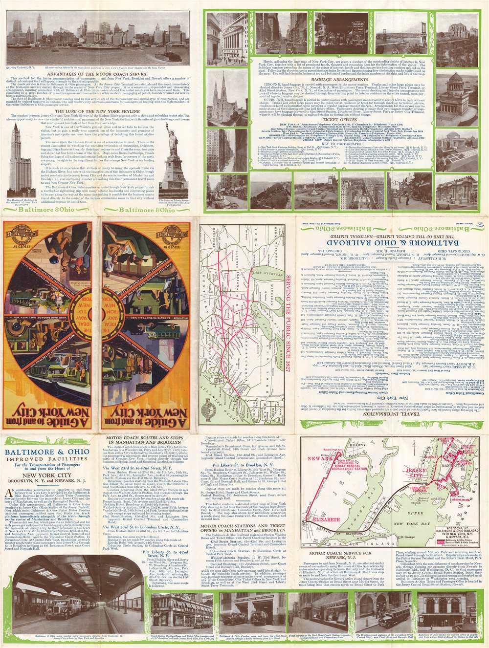
The verso also includes two inset maps, one at center of the entire B and O system and a larger map at bottom-right displaying the approach of the B and O to Jersey City, including a motor coach connection from Elizabeth to Newark.
A Closer Look
Coverage extends from 65th Street to the Statue of Liberty and from the Hudson River and Jersey City in the west to Long Island City and Downtown Brooklyn in the east. An alphanumeric grid along the border corresponds to an index at left including points of interest, hotels, theaters, and steamship lines.Several features on this map give a sense of its date, particularly the tunnels and subway lines (or lack thereof). When this map was published, the Holland Tunnel had recently been opened, seen here as the New York - New Jersey Vehicular Tunnel (Lincoln Tunnel was not opened until 1934 and the Queens Midtown Tunnel not until 1940). At this time, the subway system was divided between the Interborough Rapid Transit Company (I.R.T.) and Brooklyn–Manhattan Transit Corporation (B.M.T.). In 1932, the 'Independent' City-Owned Subway opened with the Eighth Avenue Line. In 1940, all these lines would be merged under the ownership and management of the city, reorganized under the New York City Transit Authority in 1953, which itself was placed under the administration of the Metropolitan Transportation Authority in 1968.
Meanwhile, the elevated trains in Manhattan along First, Second, Third, Sixth, and Ninth Avenue were gradually eliminated, with the last service ending in 1955. The southern portion of the New York Central Railroad line along Ninth and Tenth Avenues noted here was used for freight but with decreasing frequency. After sitting dormant for years, it was reopened as the acclaimed High Line park in 2009.
Verso Content
The verso includes a range of information, including practical matters, such as the location of ticket offices and procedures for handling baggage, as well as photographs of attractions in the city. Most of the space, however, is dedicated to touting the Baltimore and Ohio's motor coach services. This service was the result of the B and O having no tunnel rights to the tracks running into Manhattan, unlike the Pennsylvania Railroad. Therefore, rail service terminated at the Central Railroad of New Jersey Terminal along the Hudson River in Jersey City, after which passengers took a ferry to Manhattan and then boarded motor coaches (buses) to stops throughout Manhattan and Brooklyn.Although a necessary accommodation to their lack of tunnel rights, the B and O's embrace of motor coaches, in retrospect, also signaled the rise of automobiles and the decline of intercity passenger rail in the U.S. This development was aided in New York City by the urban planning philosophy championed by Robert Moses, which prioritized automobile traffic.
The verso also includes two inset maps, one at center of the entire B and O system and a larger map at bottom-right displaying the approach of the B and O to Jersey City, including a motor coach connection from Elizabeth to Newark.
Publication History and Census
This map was issued by the Baltimore and Ohio Railroad, but the map itself is copyrighted by Rand McNally, which produced similar brochures for the B and O with some regularity in the 1920s - 1930s (afterwards, Hagstrom maps were used for B and O brochures into the 1950s). The present map is the 9th edition, cataloged by the New York Public Library as 1929, which corresponds to the tunnels, subway lines, and other features present. In any edition, these brochures are quite rare. We are only aware of this edition being held by the NYPL, while other editions are held by nine other institutions.Cartographer
Rand, McNally and Co. (fl. 1856 - present) is an American publisher of maps, atlases and globes. The company was founded in 1856 when William H. Rand, a native of Quincy, Massachusetts, opened a print shop in Chicago. Rand hired the recent Irish immigrant Andrew McNally to assist in the shop giving him a wage of 9 USD per week. The duo landed several important contracts, including the Tribune's (later renamed the Chicago Tribune) printing operation. In 1872, Rand McNally produced its first map, a railroad guide, using a new cost effective printing technique known as wax process engraving. As Chicago developed as a railway hub, the Rand firm, now incorporated as Rand McNally, began producing a wide array of railroad maps and guides. Over time, the firm expanded into atlases, globes, educational material, and general literature. By embracing the wax engraving process, Rand McNally was able to dominate the map and atlas market, pushing more traditional American lithographic publishers like Colton, Johnson, and Mitchell out of business. Eventually Rand McNally opened an annex office in New York City headed by Caleb S. Hammond, whose name is today synonymous with maps and atlases, and who later started his own map company, C. S. Hammond & Co. Both firms remain in business. More by this mapmaker...
Condition
Good. Wear along fold lines and small areas of loss at fold intersections.
References
OCLC 883250788.