This item has been sold, but you can get on the Waitlist to be notified if another example becomes available, or purchase a digital scan.
1930 Student Guide Publishing Map of New York City
NewYorkCity-studentpublishing-1930$275.00

Title
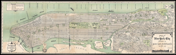
Map of New York City Published by Student Guide Publishing Co. Inc. New York, N.Y.
1930 (dated) 15.75 x 52.5 in (40.005 x 133.35 cm) 1 : 22000
1930 (dated) 15.75 x 52.5 in (40.005 x 133.35 cm) 1 : 22000
Description
A rare 1930 map of New York City published by the 'Student Guide Publishing Company.' The map covers the whole of Manhattan as well as parts of Queens. The map shows the city's streets, parks, and transportation network. Parks, rivers, islands, and more are identified using an ornate idiosyncratic typeface. Roosevelt Island, it is noteworthy, is referred to as Welfare Island, a term that was in use from 1921 to 1971, when the island was primarily occupied by hospitals. Wind heads representing the North Wind and the East Wind in the upper right and lower left corners of the map, respectively.
This map was issued by the Student Guide Publishing Company. It was sold at the 'Souvenir Shop in the Clouds,' a souvenir shop once located on the 54th floor of the Woolworth Building. A reduced version of this map was later isssued by Columbia University and sold in the Columbia University Bookstore as a guidemap for students new to the city. This map typically appears in two panels, which fold into a booklet. Here the panels have been joined and the map backed on archival tissue. Accompanied by original cardboard covers. This map is rare with only two examples appearing in the OCLC.
This map was issued by the Student Guide Publishing Company. It was sold at the 'Souvenir Shop in the Clouds,' a souvenir shop once located on the 54th floor of the Woolworth Building. A reduced version of this map was later isssued by Columbia University and sold in the Columbia University Bookstore as a guidemap for students new to the city. This map typically appears in two panels, which fold into a booklet. Here the panels have been joined and the map backed on archival tissue. Accompanied by original cardboard covers. This map is rare with only two examples appearing in the OCLC.
Condition
Very good condition. Some damage near 'Welfare Island.' Two sheets joined and backed on archival tissue. Trimmed all around to neat line as issued.
References
OCLC 15153187.