This item has been sold, but you can get on the Waitlist to be notified if another example becomes available, or purchase a digital scan.
1860 Valentine Map of New York City
NewYorkCity-valentine-1860$125.00

Title
Map of the City & County of New York. Upper Part of the City and County of New York, on a reduced Scale.
1860 (dated) 21.75 x 16.25 in (55.245 x 41.275 cm)
1860 (dated) 21.75 x 16.25 in (55.245 x 41.275 cm)
Description
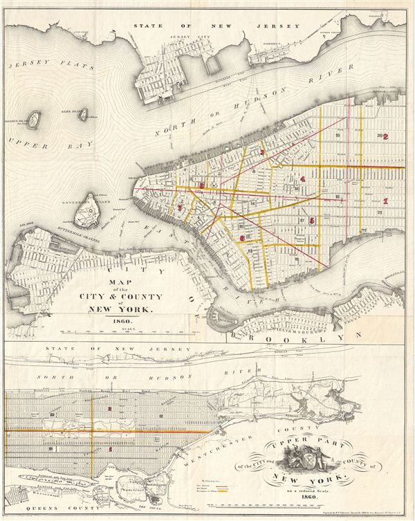
An attractive map of New York City issued in 1860 for Valentine's Manual of the Corporation of New York. Essentially two maps in one. The upper map covers the populous southern part of Manhattan as well as the adjacent parts of Jersey City, Hoboken and Brooklyn. It notes city wards, ferry routes, streets, piers, forts, and even important buildings.
The lower map details upper Manhattan from 40th street north. Like the upper map, it offers considerable detail with regard to city wards, communities, Central Park, and many individual buildings. This map also includes Blackwell's Island (Roosevelt Island), Ward's island, and Randall's Island as well as parts of Queens County. Shows the city grid pattern as far north at 154th street, beyond which the urban planning of Manhattan disintegrates into farms, institutions, and individual households. The lower map also features a decorative title cartouche featuring an American Indian, an Eagle, a European, and large heraldic crest bearing a windmill - possibly in deference to New York's Dutch heritage.
Drawn by George Hayward of 171 Pearl Street for the 1860 edition of D. T. Valentine's Manual.
Cartographer
David T. (Thomas) Valentine (1801 - 1869) served as the Clerk of the Common Council of New York City. He edited and published a series of New York City almanacs and fact books entitled Manual of the Corporation of The City of New York. Valentine's Manual, as it came to be called, included facts about the City of New York, City Council information, city history, and reported on the progress of public works such as Central Park. The production of this annual manual was the responsibility of the Clerk of the City of New York, a position held at different times by D. Valentine and by Joseph Shannon (fl. c. 1850 - 1869), who also produced a similar manual. Valentine used his manual to reproduce some of the rarest and most important maps of New York City ever created. More by this mapmaker...
Source
Valentine, D. T., Valentine's Manual of the Corporation of the City of New York, (New York) 1860.
Condition
Good. Original fold lines exhibit some wear. Professionally flattened and backed on archival tissue.
References
Haskel, D. C., Manhattan Maps, A Co-operative List, 1091.