This item has been sold, but you can get on the Waitlist to be notified if another example becomes available, or purchase a digital scan.
1874 Viele Waterway Map of New York City (w/ Bronx)
NewYorkCityWaterways-viele-1874$3,000.00

Title
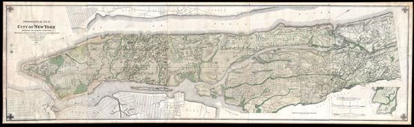
Topographical Atlas of the City of New York including the Annexed Territory, Showing original water courses and made land.
1874 (dated) 27.6 x 92 in (70.104 x 233.68 cm) 1 : 12000
1874 (dated) 27.6 x 92 in (70.104 x 233.68 cm) 1 : 12000
Description
One of the scarcest, most important and most enduring maps of New York City ever published, this is the 1874 edition of Egbert L. Viele's topography and waterways map of Manhattan. Viele first issued this map in 1864. Nearly twice the size as the 1864 edition, the present example was updated by Eugene Quackenbush, working directly under Viele, to reflect the city's 1874 annexation of the Bronx. Covering the entirety of Manhattan Island and the Bronx as far as Yonkers, Viele's map details the canals, swamps, rivers, ditches, ponds, meadows, and drainage basins of the region as they existed prior to the city's urban development. A continuously updated version of the Viele map remains in use today by architects and contractors who need take into account underground rivers and swamps that may destabilize a new construction's foundation.
Roughly translated, 'Manhattan' is an American Indian term meaning 'Island of Hills.' The American Indians living in the region prior to the Dutch settlement of Manhattan treated the island as a huge hunting and fishing reserve full of trout streams, bass swamps, and sunfish ponds. Viele contended that as streets and buildings were constructed the city's natural drainage retreated underground where, stagnating, it led to a 'humid miasmic state of the atmosphere' conducive to yellow fever, malaria, plague, and other epidemic illnesses.
Viele dedicated nearly 20 years to researching and perfecting his theories through this masterpiece of cartography. The basic map and above ground topography of the Viele map is drawn from John Randel's surveys of 1807 and the Commissioner's Plan of 1811, which formally laid out New York City's grid system. Viele then used early survey work, new survey work, and studies of older maps to recreate Manhattan's water system as it must have existed when the first Dutch settlers built a fur trading post of the tip of the island. Viele presented an unfinished early state of his map, covering only lower Manhattan to the New York State Senate in 1859, claiming,
Though Viele may never have imaged his map's most important legacy would be as a construction aid, architects, engineers, and contractors were quick to grasp its usefulness. Paul Starett, who built the Empire State Building and Stuyvesant Town, used this map to prepare estimates of construction costs. Melvin Febish, part of the team constructing the Citicorp Center, 'found that it is accurate within feet.' The builders of our own building, at 105th and Amsterdam, may not have consulted this map, for had they done so they may have noticed the underground river that has caused innumerable foundation problems in the 80 plus years since its construction.
This edition of Viele's most famous map is Eugene Quackenbush's enlarged and expanded 1874 official variant on the 1864 plan. Quackenbush recorded a conversation with Viele about the 'Waterways Map' in a 1913 document preserved in the collections of the New York Public Library
Roughly translated, 'Manhattan' is an American Indian term meaning 'Island of Hills.' The American Indians living in the region prior to the Dutch settlement of Manhattan treated the island as a huge hunting and fishing reserve full of trout streams, bass swamps, and sunfish ponds. Viele contended that as streets and buildings were constructed the city's natural drainage retreated underground where, stagnating, it led to a 'humid miasmic state of the atmosphere' conducive to yellow fever, malaria, plague, and other epidemic illnesses.
Viele dedicated nearly 20 years to researching and perfecting his theories through this masterpiece of cartography. The basic map and above ground topography of the Viele map is drawn from John Randel's surveys of 1807 and the Commissioner's Plan of 1811, which formally laid out New York City's grid system. Viele then used early survey work, new survey work, and studies of older maps to recreate Manhattan's water system as it must have existed when the first Dutch settlers built a fur trading post of the tip of the island. Viele presented an unfinished early state of his map, covering only lower Manhattan to the New York State Senate in 1859, claiming,
The Sanitary condition of any city or district or country is intimately connected with its proper drainage . . . that any inquiry into causes or remedies for sanitary evils . . . shall be based upon a thorough knowledge of the topography of the island.It took another six years of meticulous study to produce the final product – this extraordinary achievement.
Though Viele may never have imaged his map's most important legacy would be as a construction aid, architects, engineers, and contractors were quick to grasp its usefulness. Paul Starett, who built the Empire State Building and Stuyvesant Town, used this map to prepare estimates of construction costs. Melvin Febish, part of the team constructing the Citicorp Center, 'found that it is accurate within feet.' The builders of our own building, at 105th and Amsterdam, may not have consulted this map, for had they done so they may have noticed the underground river that has caused innumerable foundation problems in the 80 plus years since its construction.
This edition of Viele's most famous map is Eugene Quackenbush's enlarged and expanded 1874 official variant on the 1864 plan. Quackenbush recorded a conversation with Viele about the 'Waterways Map' in a 1913 document preserved in the collections of the New York Public Library
General Viele personally told me that his map was compiled from old maps then on file among the city records so far as relates to that portion of the city then built. But such portions of the city which were then undeveloped, were surveyed and the data obtained was used in compilation of the map... The map was compiled from a sanitary point of view to indicate the old water courses and swamp lands that existed during the early period of the city and the correctness of it has been vouched for many times in tracing contagious diseases to such localities where previous water courses had existed and subsequently filled in for the purpose of erecting buildings.Most known examples of this edition appear in atlas format, making the present compiled piece an exceptional find. Generally speaking, this later edition is much scarcer than the original and, in so far as we can ascertain, has appeared on the market only three times in the last 20 years.
CartographerS
Egbert Ludovicus Vielé (June 17, 1825 - April 22, 1902) was an American civil engineer, cartographer, businessman, and politician active in New York City during the second half of the 19th century. Born in Saratoga County, Vielé attended the United States Military Academy at West Point. Graduating in 1847, he was commissioned as a brevet second lieutenant in the 2nd United States Infantry. He served in the Mexican-American War before resigning form military duty to pursue a career as a Civil Engineer in New York City. When the call came to plan New York City's Central Park in 1856, Vielé was established as Engineer-in-Chief of the project, and it was he who set down the guidelines by which Vaux and Olmstead ultimately planned the park. He held a similar position as engineer of Prospect Park, Brooklyn from 1860. It was most likely during his tenure with the park commissions that Vielé developed his theories connecting compromised natural drainage with sanitation and infectious disease. Vielé's great cartographic masterpiece, the Topographical Map of the City of New-York, euphemistically known as the 'Vielé Map' or 'Waterways Map' evolved out of the notion that epidemic level disease evolved from excess moisture in the soil. He contended that, as New York City expanded northwards, paving over stream beds and leveling out natural drainage channels, the underground waterways would stagnate and lead to plague or worse. Though intended for the purpose of urban planning, the Vielé Map's (as it came to be known) greatest legacy is as a construction tool. To this day, contractors, architects, and engineers consult the Vielé map to determine if unseen subterranean waterways need to be taken into account when preparing building foundations. He was elected as a Democratic representative to the Forty-ninth Congress (March 4, 1885 – March 3, 1887) and ran unsuccessfully for re-election in 1886. He was heavily involved in New York real-estate interests, but also owned shares of mining and railroad companies as far off as Colorado. Vielé died in April of 1902 and was buried in an elaborate Egyptian Revival tomb at West Point. Legend tells that Vielé, paranoid that he would be buried alive, an unfortunate but surprisingly common problem in the 19th century, installed a buzzer inside his coffin that would allow him to ring the school's commanding officer should the need arise. Apparently, it did not. More by this mapmaker...
Eugene Quackenbush (1869 - after 1919) was a New York City based surveyor and draughtsman active in the late 19th and early 20th centuries. Quackenbush most notably updated Egbert L Viele's famous "Waterway Map" of New York City. He may have been a Mormon and appears to have spent some time in Chicago. A surviving manuscript letter written by Quackenbush from Chicago, regards his production of the 1874 edition of the Viele Waterway Map. There is little else known of his life. Learn More...
Julius (Julien) Bien (September 27, 1826 - December 21, 1909) was a German-Jewish lithographer and engraver based in New York City. Bien was born in Naumburg, Germany. He was educated at the Academy of Fine Arts, Cassell and at Städel's Institute, Frankfurt-am-Main. Following the suppression of the anti-autocratic German Revolutions of 1848, Bien, who participated in the pan-German movement, found himself out of favor in his home country and joined the mass German immigration to the United States. Bien can be found in New York as early as 1849. He established the New York Lithographing, Engraving & Printing Company in New York that focused on the emergent chromo-lithograph process - a method of printing color using lithographic plates. His work drew the attention of the U.S. Government Printing Office which contracted him to produce countless government maps and surveys, including the Pacific Railroad Surveys, the census, numerous coast surveys, and various maps relating to the American Civil War. Bien also issued several atlases both privately and in conjunction with a relation, Joseph Bien. At the height of his career Bien was elected president of the American Lithographers Association. After his death in 1909, Bien's firm was taken over by his son who promptly ran it into insolvency. The firm was sold to Sheldon Franklin, who, as part of the deal, retained the right to publish under the Julius Bien imprint. In addition to his work as a printer, Bien was active in the New York German Jewish community. He was director of the New York Hebrew Technical Institute, the New York Hebrew Orphan Asylum, and president of the B'nai B'rith Order. Learn More...
Condition
Very good condition. Four panels joined. Manuscript repair to title area, upper left. Additional facsimile fill repair in lower left corner. Backed on archival linen. Edged with silk.
References
Rumsey, 2509.000, (see also 3723.000). Augustyn, R. T. and Cohen, P. E., Manhattan in Maps, p. 136 - 139. Haskell, Daniel, Manhattan Maps, A Co-operative List, 1136 (see also 1132). Stokes, I. N. P., The Iconography of Manhattan Island, 1498-1909, Compiled from Original Sources and Illustrated by Photo-Intaglio Reproductions of Important Maps, Plans, Views and Documents in Public and Private Collections, vol 3, p.777-778, 1550-b. New York Public Library, Map Division, digital id: 1527362. Le Gear, C. E., Atlases of the United States, 2544. Treasures of the New York Public Library (Retrieved 10/22/12), http://exhibitions.nypl.org/treasures/items/show/35.