
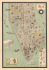
1927 Kaj Klitgaard Gilded Age Prohibition Pictorial Map of Manhattan, New York City


This item has been sold.
Island of Manhattan from The Battery to 59th Street.
Prohibition and the Gilded Age in New York.
- Digital Map Information
- Suitable for large format printing
- File Size: 58.58 MB
- File Type: ZIP / TIFF
- ICC color profile embedded
- Delivered instantly via download link
Prohibition and the Gilded Age in New York.
An utterly wonderful and extremely rare 1927 pictorial map of Manhattan, by Kat Klitgaard, reflecting, with humor, on the buoyant optimism of Prohibition-Era, pre-Depression, Gilded Age New York.A Closer Look
As the title suggests, coverage embraces Manhattan below 59th Street. Streets and avenues are named, but only the most significant buildings are specifically illustrated: Farmers Loan and Trust, Penn Station, Bellevue Hospital, The Flatiron, Wannamaker's Department Store, One Fifth Avenue, the Singer Building, all major bridges, and numerous iconic buildings in the Financial District. Subways are depicted as holes and are divided into the IRT (red) and BMT (green). African American faces, representing the famous Pullman porters, identify Grand Central and Penn Stations.To some extent, neighborhood character is highlighted - such as artists in the West Village, actors in the Theater District, a lantern to indicate Chinatown, etc. Klitgaard highlights the relative wealth and social status of individual neighborhoods, breaking them into the 'Very Rich', 'Medium Rich', and 'Not so Rich' - a subject of preoccupation in the Gilded Age. Color coding identifies certain neighbors by ethnicity: 'Germans and Austrians' (yellow), 'Russians and Poles' (pink), Italians (yellow dots), French (blue), Spaniards (green outline), and 'Near Easterners' (green dots).
The surrounding Hudson and East Rivers are full of activity ranging from navy ships (U.S.S. Texas), the U.S. Navy zeppelin (likely the Los Angeles, decommissioned in 1932), to Vanderbilt's yacht North Star. In the upper left, the recognizable profile of Charles Lindbergh's Spirit of St. Louis flies over Manhattan, likely a reference to his 1927 first solo nonstop transatlantic flight from Long Island, New York, to Paris, France, for which Lindbergh won the $25,000 Orteig Prize. At various points, wine and spirits bottles float, and prohibition enforcement vehicles patrol the waterways.
A Political Rivalry
At the top right, there are cherubic caricatures of New York Governor Alfred E. Smith (1873 - 1944) and Missouri Senator James A. Reed (1861 - 1944), the rival candidates for the Democratic nomination in the 1928 Presidential Election. The cherubs float in a cloud of smoke emitted from the luxury yacht below the compass rose. This is the 270-foot North Star, owned by Cornelius 'Neily' Vanderbilt III (1873 - 1942), a notable figure in New York Society, but not a political sponsor, to our knowledge, of either candidate. The presence of these recognizable figures and their well-documented rivalry allows us to easily date the map to 1927.Publication History and Census
This map was drawn and published in 1927 by Kaj Klitgaard, then a known New York artist. It is exceedingly rare, with only 3 examples known in institutional collections: New York Public Library, University of Syracuse, and the David Rumsey Collection (Stanford). This is the only example currently known in private hands.Cartographer
Kaj Eylye Klitgaard (May 19, 1888 - January 1, 1954) was a Danish-American novelist, illustrator, painter, and mariner active in New York in the first half of the 20th century. He was born in Denmark and studied at the Copenhagen Navigation School, which, in 1910, awarded him the title of Master Mariner. He emigrated to New York City in 1914 and was naturalized in 1915. In 1919, he married Georgina Berrian (1893 - 1977), a fellow artist. His known cartographic works include 3 known pictorial maps: Greenwich Village (1920), the Holy Land (1927), and Manhattan below 59th Street (1927). In 1937, he received a Guggenheim Fellowship to compile a study of contemporary American regional landscape painters, published in 1941. His wife, the American Georgina Klitgaard (1893 - 1977), was also a well-respected painter and sculptor. Kaj died in Kingston, New York, in 1954. Further Details...
Condition
Fine.
References
Rumsey 11160.000. New York Public Library, Map Div. 25-3134. OCLC 1548593464.