
1923 Piperjian Map of Wilsonian Armenia (Eastern Turkey, Armenia) in Armenian

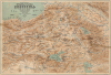

Գունավոր ընդարձակ քարտէս Հայաստանի բնական մաս. / [Colored Expanded Physical Map of Armenia.]
Calling for an Armenian State during the Armenian Genocide.
- Digital Map Information
- Suitable for large format printing
- File Size: 16.73 MB
- File Type: ZIP / TIFF
- ICC color profile embedded
- Delivered instantly via download link
Calling for an Armenian State during the Armenian Genocide.
Published in Istanbul in 1923, at the tail end of the Armenian Genocide, this remarkable chromolithograph persuasive map in the Armenian language calls for an expansive independent Armenian state. Known as 'Wilsonian Armenia', the lands mapped here roughly conform to the 1920 Treaty of Sèvres, which called for an Armenian homeland. The 'Armenian' stipulations within the treaty were never actualized. The map is almost certainly a response to the Treaty of Lausanne (1923), which effectively erased Wilsonian Armenia from the diplomatic record. Considering the context of the Armenian Genocide and open anti-Armenian sentiment in Istanbul, it is a remarkable achievement that this map was even published.A Closer Look
The map is composed entirely in Armenian. Coverage embraces from eastern central Anatolia in the Malatya region (near Nemrut Dağı) to the Karabakh (Ղարաբաղ) Steppe on the borders of modern-day Armenia and Azerbaijan, and from the Black Sea in the vicinity of the Rioni River south to Lake Urmia, a near extinct endorheic salt lake in what is today Iran. Cartographically, the map is derived from the Map of Armenia and Adjacent Countries, published in London by Edward Stanford. That map, published in English in 1915, and this map, published in Armenian in 1923, mark the beginning and end of the Armenian Genocide.Wilsonian Armenia
'Wilsonian Armenia' as mapped here refers to the territorial boundaries awarded to a presumptive Armenian state advocated by U.S. President Woodrow Wilson as part of the post-WWI Ottoman settlement known as the Treaty of Sèvres (1920). Victorious Allies envisioned a partitioned Ottoman Empire in which Armenians - who had suffered genocide during the war - would receive an independent homeland in eastern Anatolia. Wilson, the treaty arbitrator, drew borders that would have granted Armenia access to the Black Sea and significant highland territories historically congruent with the Armenia of antiquity. The plan collapsed almost immediately: the Turkish National Movement rejected Sèvres and defeated Armenian forces in the Turkish-Armenian War (September - December 1920), while the Bolsheviks reabsorbed the Republic of Armenia into the Soviet sphere. The subsequent Treaty of Lausanne (1923) erased Wilsonian Armenia from the diplomatic record, leaving most of the envisioned territory within the modern Republic of Turkey and contributing to the lasting sense of dispossession and unrealized nationhood within the Armenian diaspora.Armenian Genocide
By the time World War I (1914 - 1918) broke out, the Ottoman Empire was already in desperate straits. The Empire had already lost territory in the Balkans and North Africa and was under relentless pressure from the expansionist Russian Empire. Despite high hopes in their alliance with Germany, the Ottomans fared poorly throughout WWI, suffering further losses and accelerated internal collapse. Led by the Committee of Union and Progress (CUP), the Ottomans embraced an increasingly ethnonationalist vision that called for a Muslim pan-Turkish state. Armenians - an indigenous Christian minority with a vibrant political, cultural, and economic presence - were increasingly viewed through the lens of European intervention and as potential allies of the similarly Christian Russia.Under the cover of World War I, the empire began a methodical program intended to scapegoat ethnic Armenians, portraying them as an existential 'fifth column' allied with Russia. What followed was the Armenian Genocide (1915 - 1923), a campaign of deportation, mass killing, and cultural destruction that claimed an estimated 1.5 million lives and obliterated centuries-old Armenian communities across Anatolia. Alongside the violence, Ottoman and later Turkish authorities pursued aggressive 'Turkification' policies aimed at assimilating survivors by confiscating children and placing them in Muslim households or state orphanages, banning Armenian communal institutions, suppressing language and religious practice, and expropriating schools, churches, and property. These measures contributed not only to physical annihilation but also to cultural erasure, radically reducing the Armenian presence in its historic homelands and dispersing survivors.
Chromolithography
Chromolithography, sometimes called oleography, is a color lithographic technique developed in the mid-19th century. The process uses multiple lithographic stones, one for each color, to yield a rich composite effect. Generally, a chromolithograph begins with a black basecoat upon which subsequent colors are layered. Some chromolithographs used 30 or more separate lithographic stones to achieve the desired effect. Chromolithograph color can be blended for even more dramatic results. The process became extremely popular in the late 19th and early 20th centuries when it emerged as the dominant method of color printing. The vivid color chromolithography made it exceptionally effective for advertising and propaganda.Publication History and Census
This map is based on surveys taken, collected, and assembled by the Anglo-Irish traveler and businessman Henry Finnis Blosse Lynch (Լինչ; 1862 - 1913) and geologist Felix Oswald (Ֆ. Օսվալտ; November 3, 1966 - November 3, 1954). The two traveled throughout Armenia in 1898, where they collected a wealth of data and published separate influential works on the topic. Lynch's two-volume work Armenia: Travels and Studies (1901) was relevant well into the mid-20th century. Oswald's work, A Treatise on the Geology of Armenia (1905) was similarly significant. The present map was engraved in 1923 by M. Yghurikyan (Մ. Յղուրիկեան) and printed by O. Mogosyan (Օ. Մողոսյան), both in Istanbul. It was published by Araqel A. Piperchyan (Առաքել Պիպեռճյան). It is exceedingly rare. We see a single example, held at the National Library of Armenia, which appears in a digital archive sponsored by the British Library's Endangered Archives Program. No market history.Cartographer
Araqel Antoini Piperchyan (Առաքել Պիպեռճյան, Аракел Пипертчян, Piperjian; 1854 - 1923) was an Armenian diaspora educator and publisher based in Istanbul, which at the time Armenians still referred to as Constantinople. He published at least a few maps as well as the important 1923 'Independence Map of Armenia' and the 23-map New Political, Statistical and Commercial Pocket Atlas (Sanjagjian Printing House / Սանճագճեան Տպագրատուն, 1914). Further Details...
Condition
Fair. Visible residue from older tape repairs of large tears and left and right, just south of Lake Sevan. Old tape has been removed, with slight reinstatement at a few points. Stabilized on archival tissue.