This item has been sold, but you can get on the Waitlist to be notified if another example becomes available, or purchase a digital scan.
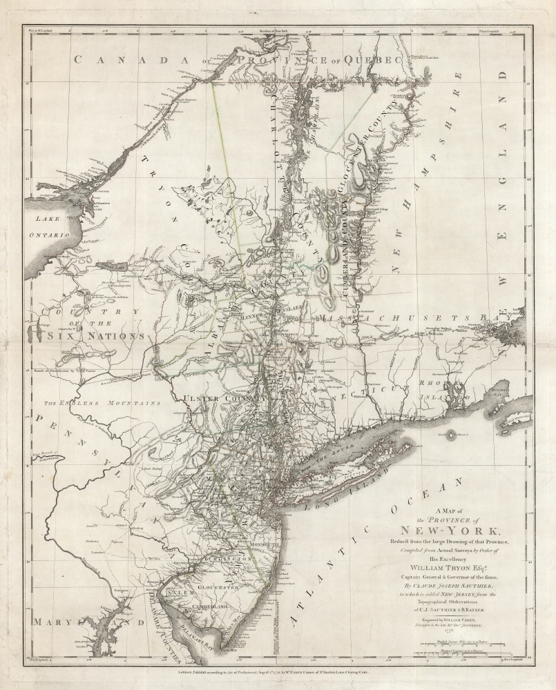
1776 Faden Map of New York and New Jersey
NewYorkNewJersey-faden-1776$1,875.00

Title
A Map of The Province of New-York, Reduc'd from the large Drawing of that Province, Compiled from Actual Surveys by order of His Excellency William Tryon Esq.r Captain General and Governor of the same, by Claude Joseph Sauthier, to which is added New-Jersey, from the Topographical Observations of C. J . Sauthier and B. Ratzer.
1776 (dated) 28.5 x 22.5 in (72.39 x 57.15 cm) 1 : 1000000
1776 (dated) 28.5 x 22.5 in (72.39 x 57.15 cm) 1 : 1000000
Description
This is an important, detailed Revolutionary War era map focusing on the New York and Massachusetts theatres of the war, published in London by William Faden in August 1776, just after the Declaration of Independence. The map summarizes the best British surveys of the region available at the beginning of the Revolutionary War. It appears to be the first printed map to show the route taken by the 'Noble Train of Artillery,' which Henry Knox famously led from Fort Ticonderoga to Boston the previous winter, resulting in the expulsion of the British from that city.
The progress of the war had, by 1776, made this route through the interior sharply relevant. Between November 1775 and January 1776, Henry Knox - whose commission to Colonel had not officially arrived - conceived and led the expedition to spirit the cannon captured at forts Ticonderoga and Crown Point across 300 miles of snowy wilderness all the way to the Boston siege camps. Knox reached Ticonderoga on December 5, 1775, and the so-called 'Noble Train of Artillery' arrived at the Dorchester Heights on January 27, 1776. Historian Victor Brooks hailed Knox's deed as 'one of the most stupendous feats of logistics' of the war. The installation of the guns on the heights overlooking Boston rendered the port untenable, and the British fleet swiftly decamped to Halifax.
The Northern Theatre
The map presents the region which lay at the center of the British plans for swiftly ending the American rebellion. The North of the map includes Montreal on the St. Lawrence River; from it, Lake Champlain and the Hudson Valley present an obvious corridor south as far as Delaware Bay, inclusive of all of colonial New York and New Jersey, as well as significant portions of adjacent Pennsylvania, Massachusetts, Connecticut, and Delaware. Vermont at this point was still part of New York (as shown) although in practice it was controlled by New Hampshire. The eastern limit of the map includes Martha's Vineyard, as well as Boston Harbor. The western reaches of the map embrace the eastern shores of Lake Ontario, and the Iroquoian lands of what is now western New York State. The map includes particularly sharp detail for the Champlain - Lake George - Hudson River corridor, and the expansive Connecticut River valley.The Noble Train of Artillery
As distinct from earlier maps of the northeast, this map also includes the sparse network of roads reaching eastwards to Boston. These include the well-known post road connecting New York and Boston along the coast. But newly added here is a road connecting Boston to Albany, via Kinderhook and Springfield. We see it on no earlier printed map. Its detail appears to be identical to that of a manuscript route map 'Plan of the roads between Boston and Albany', drawn by Francis Miller and copied by William Brasier, held in the Clements collection of the University of Michigan. The Clements dates this route map circa 1765, and it may be this early. It was not incorporated into any earlier maps of the region until the present work; the stretch of road spanning the wilds of western Massachusetts is notably absent for example from any iteration of the Mead/Jefferys map of New England.The progress of the war had, by 1776, made this route through the interior sharply relevant. Between November 1775 and January 1776, Henry Knox - whose commission to Colonel had not officially arrived - conceived and led the expedition to spirit the cannon captured at forts Ticonderoga and Crown Point across 300 miles of snowy wilderness all the way to the Boston siege camps. Knox reached Ticonderoga on December 5, 1775, and the so-called 'Noble Train of Artillery' arrived at the Dorchester Heights on January 27, 1776. Historian Victor Brooks hailed Knox's deed as 'one of the most stupendous feats of logistics' of the war. The installation of the guns on the heights overlooking Boston rendered the port untenable, and the British fleet swiftly decamped to Halifax.
A Compilation of British Surveys
This map represents a summary of mapping in New York completed by the British Corps of Engineers in the years just prior to the outbreak of the American Revolutionary War. Sauthier was the official surveyor of the province of New York from 1773 to 1776, a period that witnessed numerous boundary disputes both within the colony and with neighboring Quebec, New Hampshire, New Jersey, Pennsylvania, and Massachusetts. These disputes fostered a wealth of new survey information and encouraged a careful re-examination of older survey work - most of which was accomplished by Sauthier and those in his charge. When Sauthier briefly returned to London in 1774, he met with William Faden to publish this work, which contains not only the abovementioned work of Francis Miller, but also Bernard Ratzer's mapping of New Jersey.Other Notable Details
In addition to the various details pertinent to the Revolutionary War, this is thought to contain the first engraved mention on a map of Dartmouth College. This is due to the care with which Sauthier mapped the Connecticut River valley - perhaps considering its utility as a connection between British holdings in Canada to the New England theatre of the war. The map exhibits impressive detail in both New York and New Jersey with traces of outline color emphasizing county lines. Topography, though minimal, is rendered in hachure. The boundary line between East and West Jersey is noted, as are various conflicting boundaries associated with the New York-New Jersey border dispute. The Tienaderha River (Unadilla River) marks the western frontier of colonial power in the region and recognizes the territory of the Six Nations Tribes - with various geographical features and American Indian villages noted. In Pennsylvania, just east of the Susquehanna, Sauthier identifies a 'Great Swamp,' a vast wetland in the region of modern-day Bucks County. Today the much reduced 'Great Swamp' is called the Quakertown Swamp and is a protected wetland popular with birders.This map was engraved and published in London by William Faden in August 1776, for inclusion in his North American Atlas. The map appears on the market from time to time, but we see only five separate examples listed in institutional collections.CartographerS
Claude Joseph Sauthier (November 10, 1736 - 1802) was a French born surveyor, cartographer, and draftsman active in the British Colonies in North America just prior to the American Revolutionary War. Sauthier was born in Strasbourg, France, where he trained under Dezallier d'Agenvie and Jean Baptiste Alexandre le Blond as a garden designer and draftsman. He migrated to America in 1767 at the request of North Carolina royal governor William Tyron who was perhaps familiar with his book, A Treatis on Public Architecture and Garden Planning. Sauthier mapped much of the province of North Carolina before being promoted to the office of Surveyor of the Province of New York. Sauthier oversaw the surveying of numerous regional and provincial boundary disputes before the outbreak of the American Revolutionary War. During the Revolutionary War he was reassigned to the British Corps of Engineers, preparing an important survey for General Howe of New York and another of Staten Island. Sauthier was later attached to the staff of General Hugh Percy, who commanded the British Forces in Rhode Island. When Percy retired to his family estate, Alnwick Castle, in England, Sauthier accompanied him as a personal secretary. Ultimately, after a long, impactful, and adventurous career, Sauthier returned to his hometown of Strasburg where resided until his death on November 26, 1802. He was 66. More by this mapmaker...
Bernard Ratzer (aka Bernhard, aka Ratzen) (fl. 1756 - 1782) was an important military engineer, cartographer, and surveyor active in the mid to late 18th century. While he is often referred to as 'British', Ratzer was most certainly German. Nothing is known of Ratzer's youth. He first appears on February 20, 1756, when he is identified as one of the German officers recruited under the Commissions to Foreign Protestants Act 1756 (29 Geo. 2 c. 5) as a Lieutenant in the First Battalion of the British Royal American Regiment. The Regiment was raised to compensate for British troop shortages during French and Indian War (1754 - 1763). The Act called for engineers and officers to be German-speaking so they could effectively command the all-Germanic regiment. According to the mandate, in addition to regulars, there would be 50 officers and 20 engineers, none of which would be allowed to advance beyond the rank of lieutenant-colonel. Many of the officers and engineers, likely including Ratzer, were recruited in Europe by the swiss Engineer James Prévost. He must have already had extensive engineering training, as he was immediately assigned to work under the Dutch surveyor Samuel Holland as a lieutenant in military engineer's division. Most of his earliest survey work survives only in manuscript form, and is related to the activities of the Royal Americans. Ratzer's first recorded map, created when he was an ensign, details Maine's Passamaquoddy Bay (1756). He also completed several smaller surveys of French and Indian War forts around Lake Ontario and on the Niagara River. After the war, Ratzer was one of the 1500 victorious British troops that arrived in New York. The New York Governor Henry Moore assigned him the task of improving upon the critically flawed John Montresor map of 1767. This resulted in Ratzer's two most important maps, the 'Ratzen Plan' (1767) and the much larger 'Ratzer Map' (1776), both considered to be among the finest maps of any American city issued during the 18th century. Between surveying the 'Ratzen Plan' and the larger 'Ratzer Map,' Ratzer was next assigned to work with Samuel Holland on the New York - New Jersey Border Line Survey producing an important manuscript map in 1769, now in the Harvard University Collections. This survey work was published by William Faden in 1777, during the American Revolutionary War, as 'The Jerseys.' Due to the engraver Thomas Kitchin's misspelling of his name on the title of the 1767 Plan of the City of New York, also known as the 'Ratzen Plan,' Ratzer's name is often confused as 'Ratzen.' Ratzer must have found military life to his liking, as he remained in the British Army, achieving the rank of Captain in 1773, and Major in 1782. Learn More...
Source
Faden, W., North American Atlas, (London) 1776.
Condition
Very good. Mended fold splits to both margins, just impacting the right hand border. Faint original outline color.
References
OCLC 818338312. McCorkle, B.B., New England in Printed Maps 1513-1800: An Illustrated Carto-Bibliography, 776.25. Nebenzahl, K. Atlas of the American Revolution #37, pp. 158-60.