This item has been sold, but you can get on the Waitlist to be notified if another example becomes available, or purchase a digital scan.
1859 Egbert Viele Map of Manhattan, New York City, New York
NewYorkOriginalTopography-viele-1859$425.00

Title
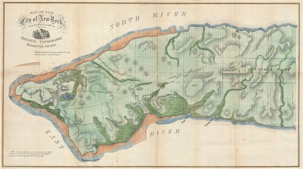
Map of the City of New York from the Battery to 80th St showing the Original Topography of Manhattan Island.
1858 (undated) 18 x 32.5 in (45.72 x 82.55 cm) 1 : 12000
1858 (undated) 18 x 32.5 in (45.72 x 82.55 cm) 1 : 12000
Description
An uncommon 1859 map of lower Manhattan, New York City, by Egbert Viele, the famed city planner who spearheaded the construction of Central Park. The map covers lower Manhattan to about 80th street and includes the city's grid plan overlaying a topographical breakdown of the city illustrating various canals, swamps, rivers, ditches, ponds, meadows, and drainage basins. Public Squares and important buildings are also noted. The fledgling Central Park, at this time approved but as yet unplanned, is blocked out. The Collect Pond, the cause of the social disintegration in lower Manhattan that lead to the development of the gang ridden Five Points, is shown, along with the original channel leading form it that eventually became Canal Street.
Viele is best known for his large format 1865 Sanitary and Topographical Map of the City and Island of New York which studies groundwater, topography, and drainage throughout the city. Viele's great map took years to compile based upon old city surveys and records. Thus this map is a remarkable discovery showing the early progress of Viele's work on the great 'Sanitary and Topographical Map' or 'Waterways Map' for which he is most famous. Viele theorized, correctly, that illness and epidemic disease in New York was caused by insufficient drainage. This theory, developed while observing a disastrous epidemic devastate a military encampment in Laredo, Texas, led not only to the development of Central Park, but also to the construction of proper drainage systems for many of the then undeveloped parts of Manhattan. Viele prepared this map shortly after his military service in Texas and early in his civilian career as a Civil and Topographical Engineer for the City of New York. It shows the early stages of his famous 'Waterways Plan' that today beard his name. This map was prepared for a report to the Senate of New York State on the sanitary condition of New York - something of which Viele had a very poor opinion. Of this map he writes,
Viele is best known for his large format 1865 Sanitary and Topographical Map of the City and Island of New York which studies groundwater, topography, and drainage throughout the city. Viele's great map took years to compile based upon old city surveys and records. Thus this map is a remarkable discovery showing the early progress of Viele's work on the great 'Sanitary and Topographical Map' or 'Waterways Map' for which he is most famous. Viele theorized, correctly, that illness and epidemic disease in New York was caused by insufficient drainage. This theory, developed while observing a disastrous epidemic devastate a military encampment in Laredo, Texas, led not only to the development of Central Park, but also to the construction of proper drainage systems for many of the then undeveloped parts of Manhattan. Viele prepared this map shortly after his military service in Texas and early in his civilian career as a Civil and Topographical Engineer for the City of New York. It shows the early stages of his famous 'Waterways Plan' that today beard his name. This map was prepared for a report to the Senate of New York State on the sanitary condition of New York - something of which Viele had a very poor opinion. Of this map he writes,
The map accompanying these remarks will serve to convey some idea of the extent of the evil to which the city is exposed, if the subject of proper drainage continues to be disregarded.The present map is unmistakably a precursor to the larger Viele Plan. Though covering a smaller area - only to 80th street, the scale and style are the same. This map even features many of the same notations. It is an exceptional, important, and scarce discovery.
Cartographer
Egbert Ludovicus Vielé (June 17, 1825 - April 22, 1902) was an American civil engineer, cartographer, businessman, and politician active in New York City during the second half of the 19th century. Born in Saratoga County, Vielé attended the United States Military Academy at West Point. Graduating in 1847, he was commissioned as a brevet second lieutenant in the 2nd United States Infantry. He served in the Mexican-American War before resigning form military duty to pursue a career as a Civil Engineer in New York City. When the call came to plan New York City's Central Park in 1856, Vielé was established as Engineer-in-Chief of the project, and it was he who set down the guidelines by which Vaux and Olmstead ultimately planned the park. He held a similar position as engineer of Prospect Park, Brooklyn from 1860. It was most likely during his tenure with the park commissions that Vielé developed his theories connecting compromised natural drainage with sanitation and infectious disease. Vielé's great cartographic masterpiece, the Topographical Map of the City of New-York, euphemistically known as the 'Vielé Map' or 'Waterways Map' evolved out of the notion that epidemic level disease evolved from excess moisture in the soil. He contended that, as New York City expanded northwards, paving over stream beds and leveling out natural drainage channels, the underground waterways would stagnate and lead to plague or worse. Though intended for the purpose of urban planning, the Vielé Map's (as it came to be known) greatest legacy is as a construction tool. To this day, contractors, architects, and engineers consult the Vielé map to determine if unseen subterranean waterways need to be taken into account when preparing building foundations. He was elected as a Democratic representative to the Forty-ninth Congress (March 4, 1885 – March 3, 1887) and ran unsuccessfully for re-election in 1886. He was heavily involved in New York real-estate interests, but also owned shares of mining and railroad companies as far off as Colorado. Vielé died in April of 1902 and was buried in an elaborate Egyptian Revival tomb at West Point. Legend tells that Vielé, paranoid that he would be buried alive, an unfortunate but surprisingly common problem in the 19th century, installed a buzzer inside his coffin that would allow him to ring the school's commanding officer should the need arise. Apparently, it did not. More by this mapmaker...
Source
Mather, Ely, Schell, Doherty, Brandreth, Report on the Sanitary Condition of the City of New-York, NY Senate no. 49, 1859.
Condition
Good. Laid down on archival tissue for stability. Verso repair and stain, left side.
References
New York Public Library, image id 5056843. New York Historical Society, NS3 M33.4.11.