This item has been sold, but you can get on the Waitlist to be notified if another example becomes available, or purchase a digital scan.
1860 Valentine View of New York City from Governors Island
NewYorkView-valentine-1860$75.00

Title
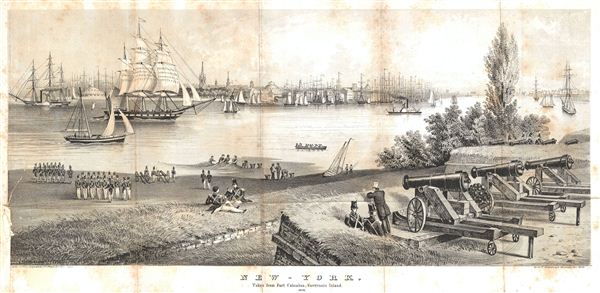
New-York. Taken from Fort Columbus, Governors Island. 1816.
1860 (undated) 8.5 x 17 in (21.59 x 43.18 cm)
1860 (undated) 8.5 x 17 in (21.59 x 43.18 cm)
Description
An attractive view of New York Harbor as it was in 1816. This view, which shows New York City as it appears from Fort Columbus on Governor's Island, was issued in the 1860 edition of Valentine's Manual. Ships fill the harbor, fishermen ply the shore, some soldiers drill, and others picnic in the grass. Several early steamships are depicted in the Hudson. engraved by the artist George Hayward of 171 Pearl Street, New York.
Cartographer
David T. (Thomas) Valentine (1801 - 1869) served as the Clerk of the Common Council of New York City. He edited and published a series of New York City almanacs and fact books entitled Manual of the Corporation of The City of New York. Valentine's Manual, as it came to be called, included facts about the City of New York, City Council information, city history, and reported on the progress of public works such as Central Park. The production of this annual manual was the responsibility of the Clerk of the City of New York, a position held at different times by D. Valentine and by Joseph Shannon (fl. c. 1850 - 1869), who also produced a similar manual. Valentine used his manual to reproduce some of the rarest and most important maps of New York City ever created. More by this mapmaker...
Source
Valentine, D. T., Manual of the Corporation of the City of New-York, 1860.
Condition
Average. Some discoloration on original folds. Foxing. Repair lower left corner.