1858 Sonnenstern Map of Nicaragua - first scientific map of that nation!
Nicaragua-sonnenstern-1858$6,000.00


Title
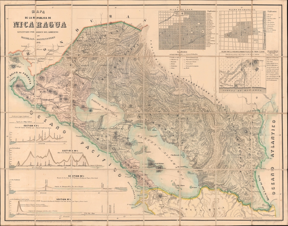
Mapa de la Republica de Nicaragua.
1858 (dated) 23.5 x 29.75 in (59.69 x 75.565 cm) 1 : 696960
1858 (dated) 23.5 x 29.75 in (59.69 x 75.565 cm) 1 : 696960
Description
This is Maximilian Sonnenstern's 1858 map of Nicaragua, the first official map of that state, here in its first edition. The map represents the first scientific survey of Nicaragua during a period when that nation held center stage as the most likely route for an interoceanic canal. It, moreover, is the earliest of Sonnenstern's seminal maps of the newly independent Central American republics. This map was followed by similarly significant maps of Guatemala and El Salvador.
Enter, in 1855, an American expansionist mercenary named William Walker (1824 - 1860). Walker was born in Nashville and was an ardent supporter American expansionism and Manifest Destiny. After failed attempts to seize control of and establish unofficial U.S. colonies in Baja California and Sonoroa, Walker arrived in Nicaragua to 'help' Liberal president Francisco Castellón defeat the Conservatives. Leading an army of approximately 160 Americans and 170 locals, Walker defeated the Conservatives (Legitimists) and declared himself president of Nicaragua. He claimed to support progressive values and wanted to modernize the country in order to entice immigration from the United States - essentially to displace or enslave the local populace. He also saw such colonies as refuges for the Southern plantation elite in the face of abolitionist movements in the United States. To such ends, he re-instituted slavery and made English Nicaragua's official language. Although supportive of the Nicaragua Canal project (which would have made him even more powerful), he railed against any foreign influence other than his own. This made him powerful enemies including English investors in the Nicaragua Canal, and American business magnate Cornelius Vanderbilt, whose Accessory Transit Company provided overland transport between the Caribbean and the Pacific through the isthmus of Rivas.
More regionally, Walker's coup also destabilized and antagonized other independent Central American states. Honduras, El Salvador, and Guatemala signed a mutual defense treaty and, under Costa Rican leadership with support from Vanderbilt, declared personal war on Walker. Under pressure from all sides, Walker surrendered on May 1, 1857, and four days later, left Nicaragua for the United States. Undaunted, Walker, returned to Central America in 1860, where he was arrested by the Royal Navy and handed over to the Honduran government, who summarily executed him.
Sonnenstern initially supported Walker's goal of colonizing Nicaragua and believed the climate conducive to U.S. and European immigration. To this end, his reports suggested sites best suited to colonial resettlement. As other Central American nations began allying against Nicaragua, Sonnenstern lost his faith in Walker's mission and fled to El Salvador - where he produced a similar map of that nation. Somewhat surprisingly, Sonnenstern's involvement with Walker's regime did not spoil his relationship with Nicaragua. The creation of the present map endeared him to Nicaraguans. Sonnenstern worked for Nicaraguan and other Central American governments until his death in 1895 and 'his funeral was attended by government ministers and other native luminaries'.
A Closer Look
Depicting the western three-fifths of modern-day Nicaragua, the map illustrates from the Gulf of Fonseca to the Atlantic Ocean and from the Honduran border and the 'depopulated' area of Nicaragua (the Mosquito Coast) to the Pacific and Costa Rica. Nicaragua's topography appears in detail with cities, villages, and connecting roads noted. Lake Nicaragua and Lake Managua appear in detail, with islands and ferry routes illustrated. Four elevation profiles in the lower left emphasize Nicaragua's daunting terrain. Inset maps of León, Granada, and Old León appear in the upper right, with locations numerically indexed.Historical Context: The Filibuster War or Walker Affair
Nicaragua gained its independence several times over the course of the first half of the 19th century. First from Spain in 1821, then from the First Mexican Empire in 1823. That same year Nicaragua joined the United Provinces of Central America, which lasted until 1838, when it split off and became an independent republic. During this entire time, warfare within Nicaragua was constant, with conflicts between Liberals in León and Conservatives in Granada degenerating into periodic civil war.Enter, in 1855, an American expansionist mercenary named William Walker (1824 - 1860). Walker was born in Nashville and was an ardent supporter American expansionism and Manifest Destiny. After failed attempts to seize control of and establish unofficial U.S. colonies in Baja California and Sonoroa, Walker arrived in Nicaragua to 'help' Liberal president Francisco Castellón defeat the Conservatives. Leading an army of approximately 160 Americans and 170 locals, Walker defeated the Conservatives (Legitimists) and declared himself president of Nicaragua. He claimed to support progressive values and wanted to modernize the country in order to entice immigration from the United States - essentially to displace or enslave the local populace. He also saw such colonies as refuges for the Southern plantation elite in the face of abolitionist movements in the United States. To such ends, he re-instituted slavery and made English Nicaragua's official language. Although supportive of the Nicaragua Canal project (which would have made him even more powerful), he railed against any foreign influence other than his own. This made him powerful enemies including English investors in the Nicaragua Canal, and American business magnate Cornelius Vanderbilt, whose Accessory Transit Company provided overland transport between the Caribbean and the Pacific through the isthmus of Rivas.
More regionally, Walker's coup also destabilized and antagonized other independent Central American states. Honduras, El Salvador, and Guatemala signed a mutual defense treaty and, under Costa Rican leadership with support from Vanderbilt, declared personal war on Walker. Under pressure from all sides, Walker surrendered on May 1, 1857, and four days later, left Nicaragua for the United States. Undaunted, Walker, returned to Central America in 1860, where he was arrested by the Royal Navy and handed over to the Honduran government, who summarily executed him.
Sonnenstern in Nicaragua
Maximilian Sonnenstern arrived in Nicaragua near the beginning of Walker's regime. As a Forty-Eighter (refugee of the failed German Revolutions of 1848), he may have shared Walker's professed goals of modernizing and colonizing Nicaragua. Sonnenstern became the official surveyor of Walker's government, producing the first scientific surveys of the region. This meticulous work included detailed reports of lakes, streams, hills, mountains, towns, vegetation, agriculture, geology, and roads. Sonnenstern's surveyors also assessed possible interoceanic canal and railroad routes.Sonnenstern initially supported Walker's goal of colonizing Nicaragua and believed the climate conducive to U.S. and European immigration. To this end, his reports suggested sites best suited to colonial resettlement. As other Central American nations began allying against Nicaragua, Sonnenstern lost his faith in Walker's mission and fled to El Salvador - where he produced a similar map of that nation. Somewhat surprisingly, Sonnenstern's involvement with Walker's regime did not spoil his relationship with Nicaragua. The creation of the present map endeared him to Nicaraguans. Sonnenstern worked for Nicaraguan and other Central American governments until his death in 1895 and 'his funeral was attended by government ministers and other native luminaries'.
Historical Context: The Nicaragua Canal
A canal connecting the Caribbean and the Pacific through Nicaragua was first considered as early as 1551, when the colonial government of New Spain conducted surveys. The idea resurfaced several times in the intervening centuries, but truly gained traction in the 1820s. Surveys were conducted and Henry Clay, then U.S. Secretary of State, introduced the plan to Congress in 1826, but it was not approved. In 1849 Cornelius Vanderbilt entered the equation, with his Accessory Transit Company gaining a 12-year contract to exclusive rights to construct the waterway, but the American Civil War and the Walker Affair prevented any progress. Efforts continued and in 1897 the United States Nicaraguan Canal Commission proposed building a canal, as did the Isthmian Canal Commission in 1899. However, the Panama Canal was built and finally opened in 1914, which distracted many from building the Nicaragua Canal, although efforts persisted. The most recent attempt began in 2012 when Wang Jing, a Chinese billionaire, began studying the feasibility of building a canal in Nicaragua. Little progress was made, and his company suffered horribly in the 2015 - 16 Chinese Stock Market Crash and the idea was abandoned.Publication History and Census
This map was created by Maximilian Sonnenstern, lithographed in East New York, and published in New York City in 1858. A second edition was published in New York in 1859 and a third edition was published in Paris in 1863. We note five examples of the 1858 edition cataloged in OCLC which are part of the collections at Princeton University, the Library of Congress, Pennsylvania State University, the University of Illinois at Urbana Champaign, and the University of Wisconsin Milwaukee. It appears that the only differences between the 1858 and 1859 editions are the date (printed in the title just after Sonnenstern's name) and that the 1859 edition was printed by Rau in New York.Provenance
The present example was recently legally deaccessioned from the Valentine Museum in Richmond, Virginia, with a stamp on the inside cover of the binder. It also bears the ownership stamp 'M. Lienau', which likely refers to Michael Martin Lienau (1816 - 1893), a German immigrant living in New York, who owned a successful wine import company, M. Lienau and Company.CartographerS
Maximilian von Sonnenstern (1819 - 1895) was a German born businessman, civil engineer, cartographer, and surveyor active in New York, Guatemala, El Salvador, and Nicaragua during the middle part of the 19th century. Sonnenstern was born in Stuttgart, Germany, and is reported to be he illegitimate scion of the royal family of Württemberg. He received military training in Germany, mastering surveying, draftsmanship, and engineering, before serving as on officer in the Württemberg army. He was active during Revolution of 1848 and was subsequently forced to flee Germany, settling in New York in 1848 or 1849. Seeking a brighter future, Sonnenstern relocated to Central American in 1855. He was not alone in doing so. In fact, there is a tradition of German engineers relocating to Central America in the mid-19th century. With political unrest at home in Germany and the broad expectation that an Atlantic-Pacific Canal was about to be built, and new political entities popping up, Central America was a dangerous yet appealing option for an enterprising and skilled engineer. Sonnenstern initially settled in Nicaragua, at the time considered the most likely candidate for an interoceanic canal, where his engineering skills earned him an official position. His work took him throughout Nicaragua as well as nearby El Salvador and Guatemala, where he met and befriended both political figures and other European ex-pat engineers. In 1858, he received an exclusive privilege to manufacture paper in the Republic of Guatemala - suggesting close ties with that country's political elite. Soon after he was commissioned to compile the first national map of Guatemala. Sometime around 1858 - 1859 he returned to the New York to manage the publication of his two most important maps, state sponsored maps of the new Central American republics of El Salvador and Guatemala. He returned to Nicaragua shortly thereafter, continuing in his state position and naturalizing as a Nicaraguan citizen in 1869. In 1874, Sonnenstern published Report of the Nicaragua Route for an Interoceanic Ship Canal, which was commissioned by the Nicaraguan minister of public works and published in the United States by the United States Coast and Geodetic Survey. Sonnenstern served in his Nicaraguan post until his death, at the age of 76. He was eulogized as a hero of the Nicaraguan republic, with cartographic legacy encompassing not just Nicaragua, but three Central American nations. We are aware four maps that can be attributed to Sonnenstern: Mapa General de la Republic de Guatemala (Kraetzer, New York, 1859) Mapa general de la Republica de Salvador (Kraetzer, New York, 1859), Mapa de las Republicas de America Central (London, 1860), Mapa de la Republica de Nicaragua (New York, 1858 and 1859, and Paris, 1863). More by this mapmaker...
Ludwig Gustav Adolph Kraetzer (March 21, 1822 - October 21, 1901), generally publishing as Gustav Kraetzer, was a German-American lithographer and printer based in New York. Kraetzer was born in Mainz, Rheinland-Pfalz, Germany. He was involved with the Revolutions of 1848 and following the suppression was forced to flee Germany. He arrived in the United States, coming through New York, in October of 1850 on the ship William Tell. He became a U.S. citizen several years later in 1856. When Kraetzer arrived in New York it has already a master lithographer, having trained in Germany. His printing concern was widely published and includes decorative prints, views, business products, advertising, and maps. Kraetzer maintained offices on Sheffield Avenue in East New York, Long Island, now part of Brooklyn. Learn More...
Condition
Very good. Dissected and mounted on linen in 32 panels as issued. Light toning and offsetting.
References
Gobat, M., Empire by Invitation: William Walker and Manifest Destiny in Central America (Cambridge, MA: Harvard University Press) 2018. OCLC 44013591, 641279070.