This item has been sold, but you can get on the Waitlist to be notified if another example becomes available, or purchase a digital scan.

1939 Showa 14 Japanese Panorama Map or View of Nikko, Japan

Nikko-showa14-1939
$137.50
Nikko. - Main View
Processing...

1939 Showa 14 Japanese Panorama Map or View of Nikko, Japan

Nikko-showa14-1939


Title


Nikko.
  1939 (undated)     7 x 30 in (17.78 x 76.2 cm)

Description


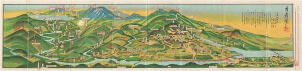
This is an extremely beautiful 1939 or Showa 14 Japanese view map of Nikko, Japan. It covers the mountainous capital city of the Tochigi Prefecture in extensive detail, featuring the Nikko railway line, cable car, lakes, falls, museums, temples and various other places of interest. Nikko is a U.N. World Heritage Site and considered to be one of the most beautiful cities in Japan. This uncommon type of map evolved out of the exposure of traditional Japanese view-style cartography and western technology. Views like this began to appear in Japan, Taiwan, and Korea in the early 20th century. Generally speaking such maps coincided with the development of railroad lines throughout the once vast Dai Nippon Teikoku or Japanese Empire. It is a distinctive style full of artistic flourish that at the same time performs a practical function. This particular map is exceptionally beautiful. It was printed via a multi-color lithographic process with delicately shaded tones and an easily comprehensible intuitive design. Essentially a transportation map, it shows the major and minor rail lines throughout Nikko, Japan. The verso of the map contains a guide to Nikko in both English and Japanese. The map folds into original art deco slipcase. All text is in Japanese and English.

Cartographer


Japanese cartography appears as early as the 1600s. Japanese maps are known for their exceptional beauty and high quality of workmanship. Early Japanese cartography has its own very distinctive projection and layout system. Japanese maps made prior to the appearance of Commodore Perry and the opening of Japan in the mid to late 1850s often have no firm directional orientation, incorporate views into the map proper, and tend to be hand colored woodblock prints. This era, from the 1600s to the c. 1855, which roughly coincides with the Tokugawa or Edo Period (1603-1886), some consider the Golden Age of Japanese Cartography. Most maps from this period, which followed isolationist ideology, predictably focus on Japan. The greatest cartographer of the period, whose work redefined all subsequent cartography, was Ino Tadataka (1745 -1818). Ino's maps of Japan were so detailed that, when the European cartographers arrived they had no need, even with their far more sophisticated survey equipment, to remap the region. Later Japanese maps, produced in the late Edo and throughout the Meiji period, draw heavily upon western maps as models in both their content and overall cartographic style. While many of these later maps maintain elements of traditional Japanese cartography such as the use of rice paper, woodblock printing, and delicate hand color, they also incorporate western directional orientation, projection systems, and structural norms. Even so, Japan's isolationist policy kept most western maps from reaching Japan so even 19th century maps appear extremely out of date. The early Japanese maps copy the great 1602 Chinese world map of the friar Matto Ricci. After Shiba Kokan's 1792 map, most Japanese cartographers used Covens and Mortier's 1730 copy of Jaillot's 1689 double hemisphere work as their base world-view. In 1862 Seiyo Sato based a new world map on Dutch sources dating to 1857, thus introducing the Mercator projection to Japan. By the late Meiji Era, western maps became far more common in Asia and Japanese maps began to follow modern conventions. More by this mapmaker...

Condition


Very good. Printed in English and Japanese. Pictures and text on verso. Folds into original binder. Minor wear along original fold lines.