This item has been sold, but you can get on the Waitlist to be notified if another example becomes available, or purchase a digital scan.
1855 Jones Archeological Map of Nineveh, Numrud, and Mosul, Iraq
NinevehTigrisZab-jones-1855$3,250.00

Title
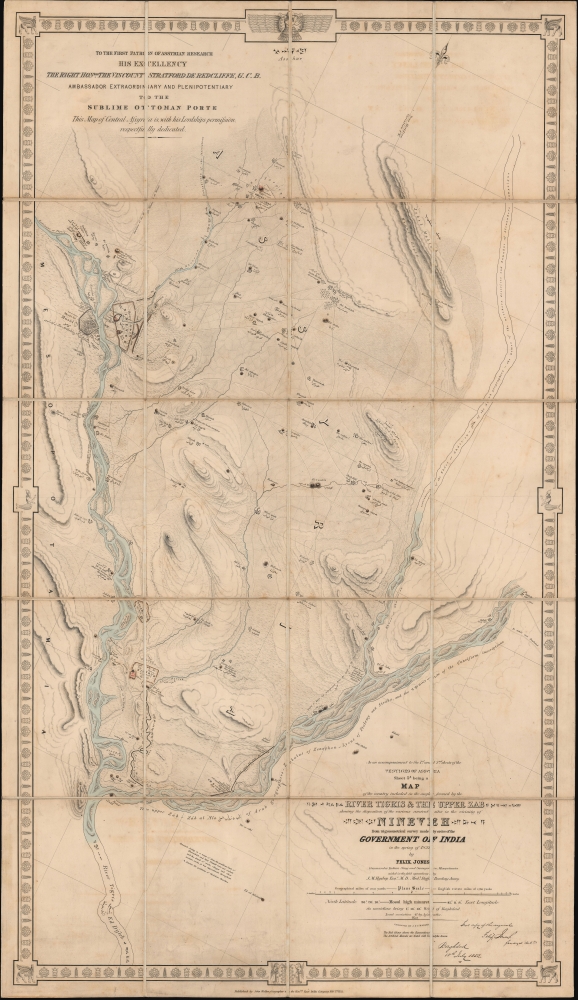
Vestiges of Assyria, sheet 3rd, being a Map of the Country in the Angle Formed by the River Tigris and the Upper Zab shewing the disposition of the various ancient sites in the vicinity of Nineveh from trigonometrical survey made by order of the Government of India in the spring of 1852.
1855 (dated) 50 x 29 in (127 x 73.66 cm) 1 : 75000
1855 (dated) 50 x 29 in (127 x 73.66 cm) 1 : 75000
Description
A very impressive 1855 map of the upper Tigris flood plain in the vicinity of Mosul, Iraq. The map is one of three prepared by James Felix Jones to illustrate the seminal Austen Henry Layard excavations at ancient Assyrian royal capitals of Nineveh and Nimrud, as well as the palace complex at Khorsabad. These excavations produced several paradigm-breaking discoveries, including the Epic of Gilgamesh and pre-Biblical 'Great Flood' narratives.
Modern excavations in Nineveh date to about 1842, when French Consul General at Mosul, Paul-Émile Botta (180 2- 1870), began to search the ruined Nineveh mounds for treasure - although with little success. The British diplomat Austen Henry Layard (1817 - 1894), who began excavations in 1847, was more successful. Although his methods were crude by modern standards, focusing on unearthing impressive trophy pieces for the glory of the empire rather than historical preservation, he did make a series of astounding discoveries, including as noted above, coniform tablets containing, among other tales, the Epic of Gilgamesh, forming a near-complete ancient mythology that had long been forgotten.
The name Nimrod is not original, instead it was first used in western writing by the Danish explorer Carsten Niebuhr (1733 - 1815). He takes the term from the name of a biblical figure mentioned in the books of Genesis and Chronicles as the 'King of Shinar' (Mesopotamia) who constructed the Tower of Babel. The true name is a matter of some debate. Possible names include: Larissa, Resen, Rehoboth, Ashur, Kalhu, and Calah. The site avoided major excavations until Austen Henry Layard began his work there in 1845. In 2015, along with a host of other irreplaceable historic sites, the ruins of Nimrud were bulldozed by the Islamic State.
A Closer Look
This work comprises the first comprehensive trigonometrical survey of the greater Mosul region - made to the exacting standards of the British military. Coverage embraces the flood plain between the Tigris and the Upper Zab Rivers from roughly the confluence of those two rivers to Mosul and the excavations of Sargon II's palace at Khorsabad. The map is extensively annotated, with text appearing not only in English, but also in Greek, Arabic, and even Cuneiform (courtesy of Rawlinson). In addition, it notes roads, ravines, tombs and temples, and small villages - some as old as Nineveh itself. The mounds of Koiyunjik and Nebbí Yúnus, the primary focus of Layard's excavations are also noted. Jones himself signs of on the map in the lower left, noting that it is an exact replica of his manuscript compiled in Baghdad in 1852. The border consists of an oriental motif with the iconic Persian lamassu figures bearing the head of Assyrian King Sargon II appearing in each corner.Nineveh
Nineveh was the capital of the Neo-Assyrian Empire from 705 - 612 BCE. During its penultimate period, Nineveh was the largest city in the world - note here how the ancient walls dwarf nearby Mosul, then as now a significant city. Nineveh also features in Biblical narrative, as well as in the Apocryphal texts, leading to its excavation being a major event in European circles who were eager to reconcile religious narrative with physical discovery. The great city fell into decline after the Assyrian Civil War (612 BCE) when it was sacked by a coalition of former subject peoples including the Babylonians, Medes, Persians, Scythians, and Cimmerians. Although it never recovered its former glory, Nineveh remained inhabited until the 13th century, when the economic, political, and population center shifted across the Tigris to Mosul.Modern excavations in Nineveh date to about 1842, when French Consul General at Mosul, Paul-Émile Botta (180 2- 1870), began to search the ruined Nineveh mounds for treasure - although with little success. The British diplomat Austen Henry Layard (1817 - 1894), who began excavations in 1847, was more successful. Although his methods were crude by modern standards, focusing on unearthing impressive trophy pieces for the glory of the empire rather than historical preservation, he did make a series of astounding discoveries, including as noted above, coniform tablets containing, among other tales, the Epic of Gilgamesh, forming a near-complete ancient mythology that had long been forgotten.
Nimrud
Nimrud was a major Assyrian city under the Neo-Assyrian Empire (911 - 605 BCE). The Assyrian King Ashurnasirpal II (883 - 859 BCE) made it the capital of his empire, constructing a magnificent palace there. It remained the capital under subsequent kings until 706 BCE when Sargon II moved the royal seat to Dur Sharrukin. Like Nineveh to the north, Nimrud was sacked during the Assyrian Civil War (612 BCE) by an alliance of former subject peoples.The name Nimrod is not original, instead it was first used in western writing by the Danish explorer Carsten Niebuhr (1733 - 1815). He takes the term from the name of a biblical figure mentioned in the books of Genesis and Chronicles as the 'King of Shinar' (Mesopotamia) who constructed the Tower of Babel. The true name is a matter of some debate. Possible names include: Larissa, Resen, Rehoboth, Ashur, Kalhu, and Calah. The site avoided major excavations until Austen Henry Layard began his work there in 1845. In 2015, along with a host of other irreplaceable historic sites, the ruins of Nimrud were bulldozed by the Islamic State.
Publication History and Census
This map was drawn by James Felix Jones in 1852. It was subsequently engraved and published in London by the house of J. and C. Walker. The map is the third of three produced by Jones. The first, also offered by Geographicus, illustrates the immediate vicinity of Mosul and Nineveh. The second depicts another ancient Assyrian capital, Nimrud, some thirty kilometers downriver. All examples of these seminal maps are rare, both as a set and individually. We note examples of this map at Harvard, the University of Chicago, the University of Wisconsin, UCLA, the Metropolitan Museum of Art, the Bibliothèque nationale de France, and Leiden University Library, Universitätsbibliothek J.C. Senckenberg in Frankfurt, and Landesbibliothek des Sachsen-Anhalts. We see no market history. This piece is owned jointly with Neatline Antique Maps.CartographerS
James Felix Jones (September 5, 1813 - September 3, 1878) was British officer of the East India Company and the Indian Navy. He served as surveyor, and amateur archeologist active in the Middle East in the mid-19th century. He was born in Shoreditch, London, England. He joined the Bombay Marine at 14, where an aptitude at mathematics led him to be taught surveying. He became involved in various British survey projects throughout the Middle East. As a midshipman on the RIMS Palinurus, he completed a series of surveys of the Red Sea littoral. By the 1820s, he was reassigned to the Persian Gulf, where he worked on the first British survey of those waters. In 1839, he surveyed Kuwait harbor. In addition to his military surveys, he accompanied Henry Creswicke Rawlinson on an overland journey from Baghdad to Hamadān, along the way producing a series of seminal archeological surveys of the ruins of antiquity. These included including the course of the ancient Nahrwan Canal (1848), the course of the Tigris and what he believed to be the site of Opis (1850), the Assyrian heartland (1852), Nimrud and Nineveh (1852), and the Baghdad area (1853). With years of Middle East experience behind him, Jones was assigned the position of Political Agent in the Persian Gulf. It has been argued that, in this capacity, he played a role in the British invasion of Persia (1856 - 1857). He retired from active service in 1862, suffering ill health and returning to London. He settled in Upper Norwood, Surrey, where he nonetheless continued to produce geographical work for the India Office. In 1875, he completed a beautifully drawn map of western Asia, including the valleys of the Tigris and Euphrates, which survives in manuscript but remains unpublished. Jones' 1878 Geographical Magazine obituary called him 'one of the greatest ornaments of the old Indian Navy'. More by this mapmaker...
John Walker (1787 - April 19, 1873) was a British map seller, engraver, lithographer, hydrographer, geographer, draughtsman, and publisher active in London during the 19th century. Walker published both nautical charts and geographical maps. His nautical work is particularly distinguished as he was an official hydrographer for the British East India Company, a position, incidentally, also held by his father of the same name. Walker's maps, mostly published after 1827, were primarily produced with his brothers Charles Walker and Alexander Walker under the imprint J. and C. Walker. Among their joint projects are more than 200 maps for the influential Society for the Diffusion of Useful Knowledge Atlas (SDUK). In addition they published numerous charts for James Horsburgh and the British Admiralty Hydrographic Office, including Belcher's important map of Hong Kong and Carless' exploratory map of Karachi. The J. and C. Walker firm continued to publish after both Walkers died in the 1870s. Learn More...
Condition
Very good. Original linen.
References
OCLC 31005511; 1252227018; 77739975; 495080532; 71568777.