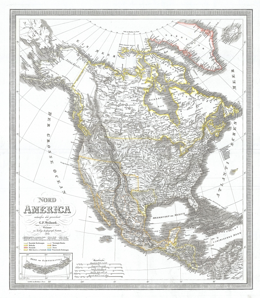
1841 Weiland Map of North America w / Republic of Texas
NordAmerica-weiland-1841$320.00

Title
Nord America.
1841 (dated) 23.5 x 20.5 in (59.69 x 52.07 cm) 1 : 16200000
1841 (dated) 23.5 x 20.5 in (59.69 x 52.07 cm) 1 : 16200000
Description
This is an 1841 Carl Ferdinand Weiland map of North America including the Republic of Texas.
A Closer Look
An ephemeral Republic of Texas that predates Texan claims in New Mexico which would give rise to the 'Stovepipe' configuration is illustrated here. The United States stretches from Atlantic to Pacific, though the border between the U.S. and Mexico is depicted at the 42nd parallel. As this map predates the Mexican-American War, this border is not unusual, however it means that most of what constitutes the modern American Southwest is still a part of Mexico. Also, the northern border of the United States contains a gap, likely reflecting the still undecided dispute between Britain and the United States over what is now British Columbia, known as the 54°40' dispute.The Geography of the Republic of Texas
The geography of Texas illustrated here predates Texas's claims to New Mexico, as stated above. Later, the Republic of Texas would claim to all land east of the Rio Grande, which extended north to modern-day Wyoming, to the U.S. border, which at that time was the Arkansas River. The Republic would exist for another five years, until Texas was formally admitted to the United States in December 1845 and ceded its sovereignty to the United States on February 19, 1846. The annexation of Texas led to a deterioration of foreign relations between the United States and Mexico due to an unresolved border dispute between Texas and Mexico and directly led to the Mexican-American War.Publication History
This map was created and published by Carl Ferdinand Weiland in 1841. It was published in Weiland's Allgemeiner Hand Atlas and a digitized example is part of the David Rumsey Map Collection.Cartographer
Carl Ferdinand Weiland (1782 - 1847) was a German cartographer active with the Weimar Geographisches Institut, where he headed up map and globe production, in early and middle part of the 19th century. Weiland was a trained as a military cartographer who, with his career at the Geographisches Institut, move into the private market. Among his other work, Weiland issued a German edition of Carey and Lea's American Atlas. Their edition, which was fully re-engraved in Germany, is of superior workmanship and stands out as some of the finest 19th century maps of individual U.S. states printed outside of America.Carl Ferdinand Weiland (1782 - 1847) was a German cartographer active with the Weimar Geographisches Institut, where he headed up map and globe production, in early and middle part of the 19th century. Weiland was a trained as a military cartographer who, with his career at the Geographisches Institut, move into the private market. Among his other work, Weiland issued a German edition of Carey and Lea's American Atlas. Their edition, which was fully re-engraved in Germany, is of superior workmanship and stands out as some of the finest 19th century maps of individual U.S. states printed outside of America. More by this mapmaker...
Condition
Very good. Even overall toning.
References
Rumsey 9074.064.