This item has been sold, but you can get on the Waitlist to be notified if another example becomes available, or purchase a digital scan.
1747 Bowen Map of North America
NorthAmerica-bowen-1747$250.00

Title
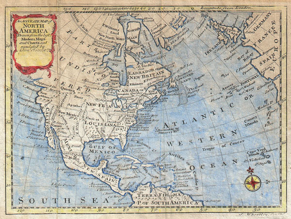
An Accurate Map of North America, Drawn from the Best Modern Maps and Charts and Regulated By Astronl. Observatns.
1797 (date obscured) 6.25 x 8 in (15.875 x 20.32 cm)
1797 (date obscured) 6.25 x 8 in (15.875 x 20.32 cm)
Description
This is a curious little map of North America. Covers the whole North America as well as parts of Europe and South America. This is a pirated 1797 reissue of Bowen 1747 map of the same name. Wheatley seems to have stolen the map and updated it solely by scratching out Bowen's name from the title cartouche. Nonetheless, this map is cartographically interesting with much to recommend it. Shows North America in Colonial times with a misshapen Florida and California. Lists the Apache Indians and the 'Supposed Strait of Annian.' Anian is a term derived from a John Donne poem, 'Anyan if I go west by the North-West passage.' However, it was interpreted as the Bering Strait by cartographers, successfully transitioning it from the realms of poetry to cartography. Anian presupposed the existence of a Northwest Passage and, as such, was entirely mythical, though the lands that are now Alaska long bore that name. Further south still we find Quivira, one of the legendary northern American Kingdoms of Gold. Much of Modern day Canada is labeled 'Parts Undiscovered.' Includes the Fishing Banks off Newfoundland and offers fairly accurate details of the Caribbean. Prepared by Wheatley for D. Fenning's 1797 issue of A New and Easy Guide to the use of Globes; and the Rudiments of Geography. .
CartographerS
Samuel Wheatley (fl. c. 1744 - 1763) was a Dublin based engraver active in later part of the 18th century. He operated his engraving business from the shop of an ironmonger known only as "Mr. Costigan", in Salutation Alley, Dublin. His is known to have engraved maps for Faulkner's edition of Sale's Universal History and Smith's History of Waterford. He also seems to have made a map of Lough Neagh for Barton's "Lectures on Natural Philosophy. Though is described by contemporaries as an "Engraver of Note", he seems to have had no qualms about blatantly pirating the work of others. He died in 1771. Little else is known. More by this mapmaker...
Emanuel Bowen (1694 - May 8, 1767) had the high distinction to be named Royal Mapmaker to both to King George II of England and Louis XV of France. Bowen was born in Talley, Carmarthen, Wales, to a distinguished but not noble family. He apprenticed to Charles Price, Merchant Taylor, from 1709. He was admitted to the Merchant Taylors Livery Company on October 3, 1716, but had been active in London from about 1714. A early as 1726 he was noted as one of the leading London engravers. Bowen is highly regarded for producing some of the largest, most detailed, most accurate and most attractive maps of his era. He is known to have worked with most British cartographic figures of the period including Herman Moll and John Owen. Among his multiple apprentices, the most notable were Thomas Kitchin, Thomas Jeffreys, and John Lodge. Another apprentice, John Oakman (1748 - 1793) who had an affair with and eventually married, Bowen's daughter. Other Bowen apprentices include Thomas Buss, John Pryer, Samuel Lyne, his son Thomas Bowen, and William Fowler. Despite achieving peer respect, renown, and royal patronage, Bowen, like many cartographers, died in poverty. Upon Emanuel Bowen's death, his cartographic work was taken over by his son, Thomas Bowen (1733 - 1790) who also died in poverty. Learn More...
Source
Fenning, Daniel, A New and Easy Guide to the use of Globes; and the Rudiments of Geography. (1797 edition)
Condition
Good condition. Original folds. Age toning. Minor water stains. Contemporary color.
References
New York Public Library, Map Division, 1258748. Phillips (North America), page 595.