This item has been sold, but you can get on the Waitlist to be notified if another example becomes available, or purchase a digital scan.
1828 Finley Map of North America
NorthAmerica-finley-1828$112.50

Title
North America.
1828 (undated) 11.5 x 9 in (29.21 x 22.86 cm) 1 : 33000000
1828 (undated) 11.5 x 9 in (29.21 x 22.86 cm) 1 : 33000000
Description
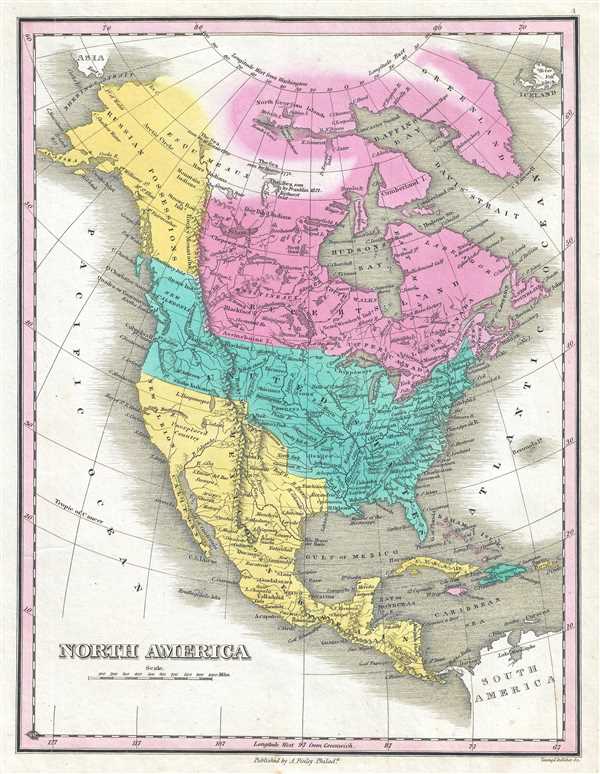
This is Anthony Finley's desirable 1827 map of the North America. The map depicts the continent from Panama to the Arctic Circle, including Greenland, Iceland, and the northwestern tip of Asia. The U.S. claims to British Columbia prior to the 1818 compromise that set the boundary at the 49th parallel are illustrated. Mexico's claims to Upper California are included as well, here labeled 'New Albion' and 'Unexplored Territory.'
Finley curiously charts two lakes in the Great Basin, one labeled Timpanagos and another smaller lake further south labeled 'Salt Lake.' The Great Salt Lake is said to have first been seen by Europeans in 1824, only a few years before this map was published, so it is unlikely that Finley drew from this exploration. Instead, Finley is following Escalante's discoveries as recorded on the Miera map. The Escalante expedition actually visited Utah Lake (Timpanagos), but only heard about the Great Salt Lake from local native American Ute tribe. Miera, Escalante's cartographer, thus mapped Timpanagos as much larger than the unseen 'Great Salt Lake.'
In addition, Finley maps the Buenaventura River running from the Rocky Mountains westward through 'Salt Lake' and westward to San Francisco Bay. The Buenaventura is the last incarnation of the apocryphal River of the West, a long sought after speculative alternative to the Northwest Passage. The mapping of Buenaventura here again references legitimate discoveries by Escalante of the White River and the Sevier River. In this case, both are mistakenly associated with the River of the West and given an erroneous outlet into San Francisco Bay.
There are additional notations on several Arctic expeditions in northern Canada by Kensir (1789), Hearne (1771) and Franklin (1821). Each identified a sea between the 60th and 70th parallel. Though not fully explored until later, these are most likely the first sightings of Dolphin and Union Strait, Austin Bay, Coronation Gulf, and the Dease Strait. These bodies of water lie between the North American mainland and Victoria Island.
Engraved by Young and Delleker for the 1828 edition of Anthony Finley's General Atlas.
Cartographer
Anthony Finley (August 25, 1784 - June 9, 1836) was an American book and map publisher based in Philadelphia, Pennsylvania. Finley was born in Philadelphia in 1784. He opened a bookshop and publishing house at the Northeast corner of Fourth and Chestnut Street, Philadelphia in 1809. His earliest known catalog, listing botanical, medical and other scientific works, appeared in 1811. His first maps, engraved for Daniel Edward Clarke’s Travels in Various Countries of Europe, Asia, and Africa also appear in 1811. His first atlas, the Atlas Classica, was published in 1818. He soon thereafter published the more significant A New American Atlas and the New General Atlas…, both going through several editions from 1824 to 1834. Although most of Finley's cartographic material was borrowed from European sources, his atlases were much admired and favorably reviewed. In addition to his work as a printer, Finley ran unsuccessfully on the 1818 Democratic ticket for Philadelphia Common Council. He was a founding officer of the Philadelphia Apprentices’ Library, and a member of both the American Sunday-School Union and the Franklin Institute. He was also an ardent supporter of the American Colonization Society, an organization dedication to returning free people of color to Africa - which led to the founding of Liberia. Much of his wealth was dedicated to supporting this cause. Finley was active as a publisher until his 1836 death, apparently of a 'lingering illness.' Shortly thereafter advertisements began appearing for his map business and plates, most of which were acquired by Samuel Augustus Mitchell. More by this mapmaker...
Source
Finley, Anthony, A New General Atlas, Comprising a Complete Set of Maps, representing the Grand Divisions of the Globe, Together with the several Empires, Kingdoms and States in the World; Compiled from the Best Authorities, and corrected by the Most Recent Discoveries, Philadelphia, 1828.
Condition
Very good. Blank on verso.
References
Rumsey 0285.004 (1831 edition). Phillips (Atlases) 4314, 760, 752, 6045.