1759 Gibson Map of North America
NorthAmerica-gibson-1759$400.00

Title
North America.
1759 (undated) 12 x 13.5 in (30.48 x 34.29 cm) 1 : 43000000
1759 (undated) 12 x 13.5 in (30.48 x 34.29 cm) 1 : 43000000
Description
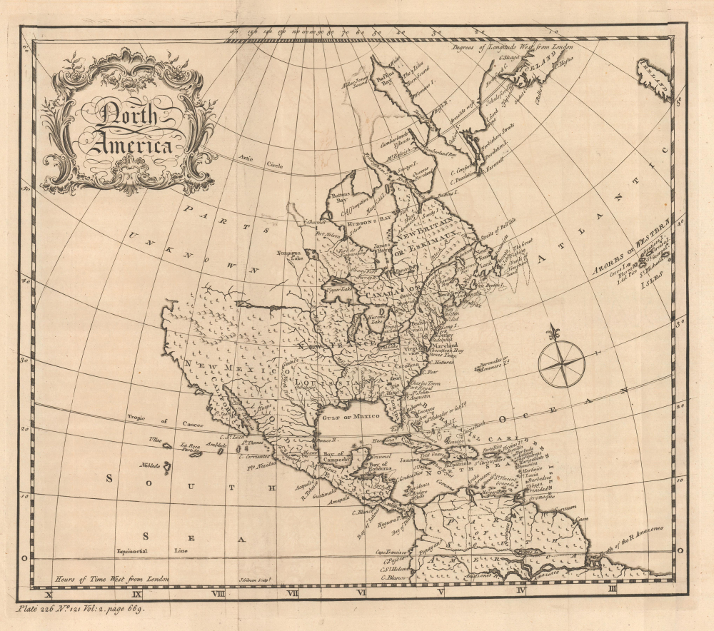
This is a c. 1759 map of North America engraved by John Gibson for Thomas Salmon's The Universal Traveller: Or, a Compleat Description of the Nations of the World. It is notable for reflecting the still-speculative nature of the continent's geography, including suggestions of a possible Northwest Passage.
The Pacific Northwest is marked 'Parts Unknown' and left blank except for part of Lanhotan's Longue River (extending west from the Mississippi River, see our listing of Lahontan's map Carte de la Riviere Longue et des quelques Autres) and another river further west tantalizingly hinting at the possibility of a passage to the Pacific. This second river would be roughly congruent with the Columbia River; Europeans did not discover it until after this map's publication, but cartographers had long speculated about the existence of a major river in the region. Similarly, an apocryphal 'Prime Lake' appears just north of the Amazon River. Some placenames employed here were later supplanted, such as Upper Lake (Lake Superior), Ilenese Lake (Lake Michigan), and Frontenac Lake (Lake Ontario).
A Closer Look
This map of North America extends to include northern South America, Ireland, and the Azores Islands. The British Colonies are confined along the eastern seaboard, with the cities of Boston, New York, Philadelphia, Williamsburg, Jamestown, Charleston, and Port Royal recorded. Occasional cities are similarly marked elsewhere. Trees appear throughout, accurately enough for much of the lands seen here but less so for the Great Plains and the great deserts of what is now the southwestern United States and north-central Mexico. The map is adorned with a delicately engraved title cartouche and a simple compass rose.The Pacific Northwest is marked 'Parts Unknown' and left blank except for part of Lanhotan's Longue River (extending west from the Mississippi River, see our listing of Lahontan's map Carte de la Riviere Longue et des quelques Autres) and another river further west tantalizingly hinting at the possibility of a passage to the Pacific. This second river would be roughly congruent with the Columbia River; Europeans did not discover it until after this map's publication, but cartographers had long speculated about the existence of a major river in the region. Similarly, an apocryphal 'Prime Lake' appears just north of the Amazon River. Some placenames employed here were later supplanted, such as Upper Lake (Lake Superior), Ilenese Lake (Lake Michigan), and Frontenac Lake (Lake Ontario).
The Contentious Search for a Northwest Passage
Aside from the curious rivers in the western parts of the continent mentioned above, the map leaves open the possibility of a Northwest Passage via Cape Churchill or Hudson Bay and waterways to its north. The search for a Northwest Passage to circumvent the inconvenience of North America began in the 16th century. As more of the North American continent was explored, particularly by traders of the Hudson's Bay Company, the potential for an easily navigable passage seemed increasingly remote. As the company was concerned first and foremost with commerce, it did little to promote voyages of exploration. Opponents of the company like Arthur Dobbs (1689 - 1765), later governor of North Carolina, tried to have its monopoly revoked in the belief that this would encourage more daring attempts to find a Northwest Passage. Dobbs' efforts to have the monopoly revoked failed, though he did help to generate greater interest in the search for an Arctic Northwest Passage (aided by improved, sturdier ships). Unfortunately for Dobbs, these new explorations seemed to only confirm that no such passage existed; it was only in the early 20th century that a ship under Roald Amundsen's leadership was able to navigate the Northwest Passage, passing through Baffin Bay, then weaving through the Arctic islands of northern Canada, and finally passing along the northern coast of Alaska to the Bering Strait and the Pacific Ocean beyond.Publication History and Census
This map was engraved by John Gibson for publication in the book The Universal Traveller: Or, a Compleat Description of the Nations of the World by Thomas Salmon, published in London by Richard Baldwin in 1759. Salmon's work served as a cultural and physical geography of Europe, Africa, and the Americas, incorporating illustrations adapted from earlier notable travel accounts, including many after De Bry. This map is independently cataloged at Yale University, the New York Public Library, Johns Hopkins University, the Library of Congress, and the Birmingham Public Library in the OCLC, while Salmon's entire work is more widespread.CartographerS
John Gibson (1724 – 1773) was an English map engraver active in London at the end of the 18th century. Gibson was the son of a locksmith. In 1739 he apprenticed to John Blundell as a stationer of Grub Street. Gibson proved a fine engraver and was much in demand by London map publishers. During his career he produced thousands of maps and was admired as a skilled engraver and sculptor. Among others, he engraved for Emanuel Bowen, Robert Sayer, Jean Palairet, John Rocque, Andrew Dury, and Benjamin Martin. His best known work was prepared in conjunction with Gentleman's Magazine. Gibson, sadly, was not as astute in his fiscal affairs as with the engravers pen and consequently spent much of his life consigned to debtor's prison. More by this mapmaker...
Thomas Salmon (1679 - January 20, 1767) was a largely self-educated English historian, who spent time living in both the East and West Indies. Salmon was born in Meppershall, Bedfordshire. His father (also Thomas) was a cleric and musical scholar while his older brother Nathaneal was a Classicist, but was known more for his accounts of travel and folklore throughout England than his work on Roman history. Other details on the life of Thomas Salmon (the younger) are scant. After his seemingly many travels throughout the world, he lived in Cambridge and may have studied there, as his older brother had, as well as running a coffeeshop, before moving to London. Salmon participated in Lord Anson’s circumnavigation (1740 - 1744) and went on to publish extensively in the fields of geography and travel, contributing to world gazetteers, geographical grammars, histories, and narrative accounts. Most of the details of his life come from the clergyman and antiquarian William Cole (1714 - 1782), who was Salmon's friend. Learn More...
Source
Salmon, T., The Universal Traveller: Or, a Compleat Description of the Nations of the World, (London: Richard Baldwin) 1759.
Condition
Very good. Some Transference and wear on old fold lines.
References
OCLC 82972336.