1792 Kitchin Map of North America
NorthAmerica-kitchin-1787$350.00

Title
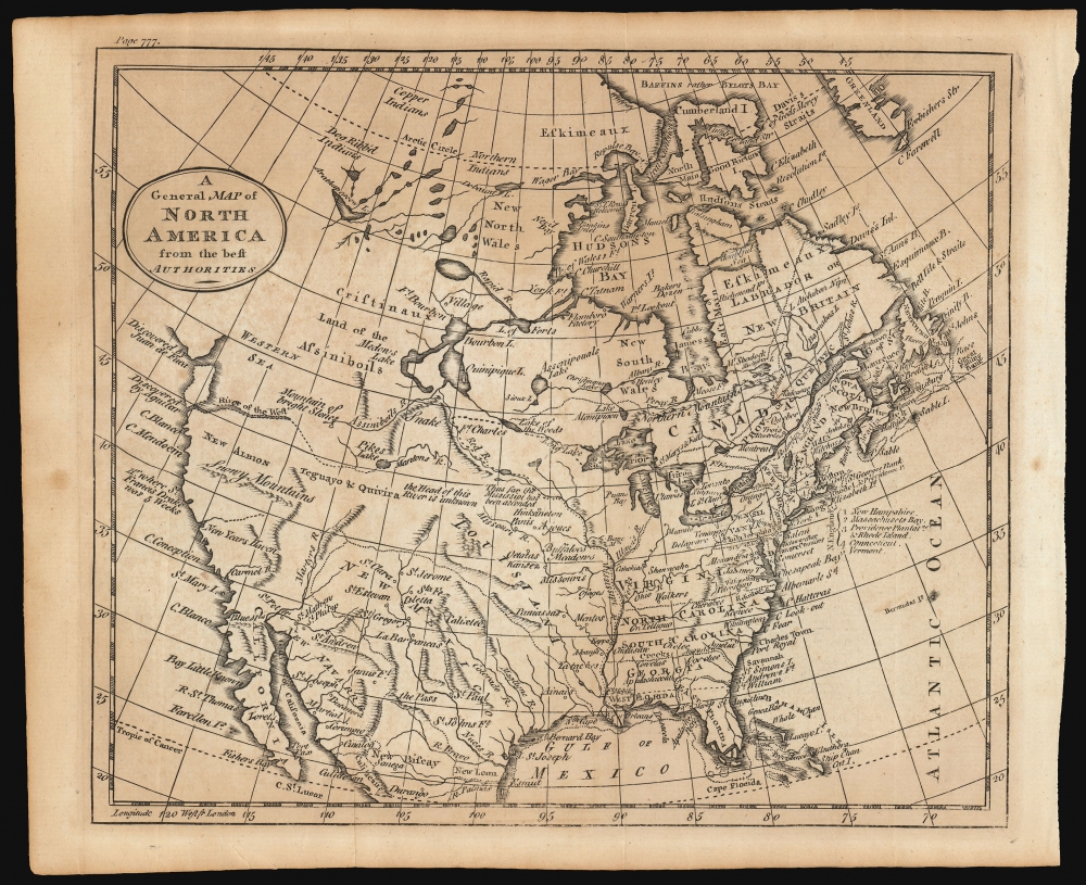
A General Map of North America from the Best Authorities.
1787 (undated) 7.5 x 9 in (19.05 x 22.86 cm) 1 : 33000000
1787 (undated) 7.5 x 9 in (19.05 x 22.86 cm) 1 : 33000000
Description
This is Thomas Kitchin's 1787 map of North America. Although it does not name the United States prominently - possibly a deliberate oversight for the benefit of British audiences still smarting from their defeat - the map provides a fair reflection of the situation in North America following the Revolution.
Kitchin's map is predominantly a reduced and updated version of his own c. 1770 work A New and Accurate Map of North America. In addition to the notes reflecting the birth of the United States, the present map contains detail in northern Canada not present on the earlier one: Samuel Hearne's 1772 discoveries in the Coppermine River region, including the 'Copper Indians' and the 'Dog Ribb'd Indians'. The 1770 map contains nothing in this region beyond the statement, 'These Parts are unknown'.
A Closer Look
The new border between the new nation and Canada is marked (with 'United States' in extremely fine print). The former colonies are named, as are East and West Florida. French Louisiana is labeled, as is the Spanish territory of New Mexico. The mountains of the west are shown in extremely speculative fashion - with a large range of 'Snowy Mountains' and a 'Mountain of Bright Stones'. The Pacific Northwest is marked with the imagined 'Western Sea', an iteration of the fraudulent French Mer de la Ouest.Kitchin's map is predominantly a reduced and updated version of his own c. 1770 work A New and Accurate Map of North America. In addition to the notes reflecting the birth of the United States, the present map contains detail in northern Canada not present on the earlier one: Samuel Hearne's 1772 discoveries in the Coppermine River region, including the 'Copper Indians' and the 'Dog Ribb'd Indians'. The 1770 map contains nothing in this region beyond the statement, 'These Parts are unknown'.
Publication History and Census
This map first appeared in the 1787 edition of A New Geographical, Historical, and Commercial Grammar. This second state example, distinguishable by the presence of an engraved page number 777 in the upper left, appeared in the 1792 edition of the same work. The book is well represented in institutional collections and the separate map appears on the market from time to time.Cartographer
Thomas Kitchin (August 4, 1718 – June 23, 1784) was a London based engraver, cartographer, and publisher. He was born in London to a hat-dyer of the same name. At 14, Kitchin apprenticed under Emanuel Bowen, under whom he mastered the art of engraving. He married Bowen daughter, Sarah Bowen, and later inherited much of his preceptor's prosperous business. Their son, Thomas Bowen Kitchin, also an engraver joined the family business, which thereafter published in Thomas Kitchin and Son. From 1858 or so Kitchin was the engraver to the Duke of York, and from about 1773 acquired the title, 'Royal Hydrographer to King George III.' He is responsible for numerous maps published in the The Star, Gentleman's Magazine, and London Magazine, as well as partnering with, at various times, with Thomas Jefferys, Emmanuel Bowen, Thomas Hinton, Issac Tayor, Andrew Dury, John Rocque, Louis de la Rochette, and Alexander Hogg, among others. Kitchin passed his business on to his son, Thomas Bowen Kitchin, who continued to republish many of his maps well after his death. Kitchin's apprentices included George Rollos, Bryant Lodge, Thomas Bowen Kitchin, Samuel Turner Sparrow, John Page, and Francis Vivares. More by this mapmaker...
Source
Kitchin, T., A New Geographical, Historical, and Commercial Grammar and Present State of the Several kKingdoms of the World, (London: Charles Dilly) 1792.
Condition
Very good. Light foxing and toning.
References
OCLC 124036051.