This item has been sold, but you can get on the Waitlist to be notified if another example becomes available, or purchase a digital scan.
1783 / 1793 Jean Lattré Map of North America
NorthAmerica-lattre-1783$175.00

Title
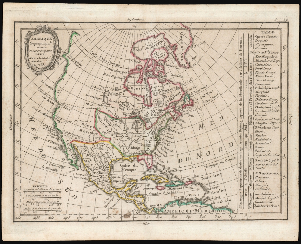
Amerique Septentrionale diviseé en ses principaux Etats. A Paris chez Lattré Avec priv... 1783.
1783 (dated) 7.25 x 10 in (18.415 x 25.4 cm) 1 : 49000000
1783 (dated) 7.25 x 10 in (18.415 x 25.4 cm) 1 : 49000000
Description
This is an attractively-engraved 1793 Jean Lattré map of North America, showing the new political divisions of the continent following the American Revolution.
A Closer Look
The map covers a broad area, from Terra Firma in South America up to Baffin's Bay and Greenland. Mountains are indicated with hachures. Major rivers are depicted accurately in Mexico and east of the Mississippi watershed. In the west, few details appear beyond some extremely optimistic rivers sprouting as far inland as Montana and Wyoming, thus revealing the lack of knowledge of the mountains making such rivers impossible. The Pacific coast is reasonably well understood, however. The chimera of the Sea of the West is absent here, and there is a note indicating the Russian discoveries in the vicinity of Alaska. A table at the right details the locations of the thirteen states, principal cities, and Indian nations. The table also enumerates the remaining possessions of the French, English and Spanish.Publication History and Census
This map was engraved by Jean Denis Janvier in 1783 for inclusion in Jean Lattré's Petit Atlas Moderne. We are aware of three states of this map, distinguishable by their imprint. The first state bears the imprint A Paris chez Lattré Avec Priv du Roi. The second state, appearing in 1793, is identical but for the partial obliteration of du Roi: Louis XVI had been executed January of that year. The Petit Atlas Moderne would be republished, again without substantial change, in 1800 by Delamarche, when Lattré's imprint was replaced. All three states are dated 1783. We see one separate example of the first state in Birmingham's Jefferson Public Library. We see only a dozen examples of the atlas in institutional collections, five of which correspond to the 1793 edition.CartographerS
Jean Denis Janvier (fl. 1746 - 1776), sometime also known as 'Robert', was a Paris based cartographer active in the mid to late 18th century. Janvier signed his maps Signor Janvier. By the late 18th century, Janvier was awarded the title of 'Geographe Avec Privilege du Roi' and this designation appears on many of his later maps. Janvier worked with many of the most prominent French, English and Italian map publishers of his day, including Longchamps, Faden, Lattre, Bonne, Santini, Zannoni, Delamarche, and Desnos. More by this mapmaker...
Jean Lattré (170x - 178x) was a Paris based bookseller, engraver, globe maker, calligrapher, and map publisher active in the mid to late 18th century. Lattré published a large corpus of maps, globes, and atlases in conjunction with a number of other important French cartographic figures, including Janvier, Zannoni, Bonne and Delamarche. He is also known to have worked with other European cartographers such as William Faden of London and the Italian cartographer Santini. Map piracy and copyright violations were common in 18th century France. Paris court records indicate that Lattré brought charges against several other period map publishers, including fellow Frenchman Desnos and the Italian map engraver Zannoni, both of whom he accused of copying his work. Lattré likes trained his wife Madame Lattré (né Vérard), as an engraver, as a late 18th century trade card promotes the world of 'Lattré et son Epouse.' Lattré's offices and bookshop were located at 20 rue St. Jaques, Paris, France. Later in life he relocated to Bordeaux. Learn More...
Source
Lattre, Jean, Petit Atlas Moderne..., (Paris: Lattré) 1793.
Condition
Very good. Tallow spot in lower border; lightly toned; original outline color.
References
OCLC 925376545 (1783) Rumsey 0421.023 (1800 Delamarche).