This item has been sold, but you can get on the Waitlist to be notified if another example becomes available, or purchase a digital scan.
1852 Levasseur Map of North America (w/ Republic of Texas)
NorthAmerica-levasseur-1852$275.00

Title
Amerique Septentrionale.
1852 (undated) 12.5 x 17.5 in (31.75 x 44.45 cm) 1 : 40000000
1852 (undated) 12.5 x 17.5 in (31.75 x 44.45 cm) 1 : 40000000
Description
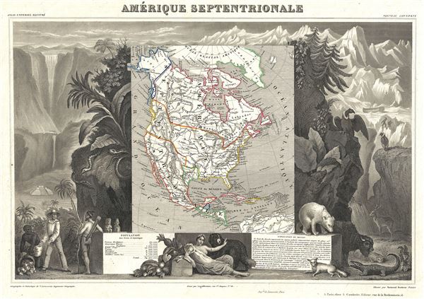
A visually stunning decorative map of North America dating to 1852, by French map publisher Victor Levasseur. Levasseur published several different editions of his North America map - this being the most desirable due to its depictions of the ephemeral Republic of Texas. Though cartographically minimalist, there are a number of additional important elements that are worthy of note. These include the extension of Oregon territory well into British Columbia, reflecting the American claims that later led to the 54 40' dispute. Also, the Northwest Passage from Atlantic to Pacific is drawn as an open and practically navigable seaway.
By far this map's most striking feature is its elaborate allegorical border work. Levasseur composed this map for publication in his magnificent Atlas Nationale de la France Illustree, one of the most decorative and beautifully produced atlases to appear in the 19th century.
This particular map is surrounded by wide and elaborate illustrative border work showing the cultural, natural, and trade richness of the Americas. The left hand side of the map depicts European seamen bargaining for indigenous products. In the background is a Mesoamerican style pyramid, dramatic mountain scenery, and a railroad train. The right hand side of the map shows a cross-section of the flora and fauna common to the continent, including a Bison, vultures, a polar bear, an elk, a fox and an alligator. In the undergrowth, a leopard lies hidden. At the base of the map a classically dressed woman lounges with a St. Bernard and Bale of Cotton. To either side her text boxes offer additional information about the discovery, history, and culture of the region. A population table appearing at the bottom of the map gives statistics for the Arctic (50,000), Alaska or Russian America (50,000), British America (1,200,000), the United States (19,000,000), Texas (200,000), Mexico (8,000,000), Guatemala (3,000,000), and the Antilles (2,720,000).
Published by V. Levasseur in the 1852 edition of his Atlas National de la France Illustree.
Cartographer
Victor Levasseur (1800 - 1870), an important French engineer, cartographer, and engraver of the mid 19th century, held a number of important cartographically related political and educations posts in France. He is most famous for his Atlas National Illustré des 86 Départements et des Possessions de La France, a large decorative atlas of France, including his Planisphere and five important continental maps. Levasseur's maps are distinctive for their wide decorative margins containing elaborate depictions of the scenery, peoples, and trade goods of the areas he mapped. Levasseur maps are also known to offer a wealth of statistical data. Until recently, very few Levasseur Atlases migrated out of France where they were mostly used in public libraries and town halls. His work represents some of the last great decorative atlases of the 19th century. More by this mapmaker...
Source
Levasseur, V., Atlas National Illustre des 86 Departements et des Possessions de La France Divise par Arrondissements, Cantons et Communea avec La Trace de Toutes Les Routes, Chemins, de fer et Canaux., 1852 edition.
Condition
Very good. Blank on verso.
References
Rumsey 0427.096 (1856 edition). Phillips (Atlases) 3003.