This item has been sold, but you can get on the Waitlist to be notified if another example becomes available, or purchase a digital scan.
1828 Malte-Brun Map of North America
NorthAmerica-maltebrun-1828$75.00

Title
North America.
1828 (undated) 10 x 8.5 in (25.4 x 21.59 cm)
1828 (undated) 10 x 8.5 in (25.4 x 21.59 cm)
Description
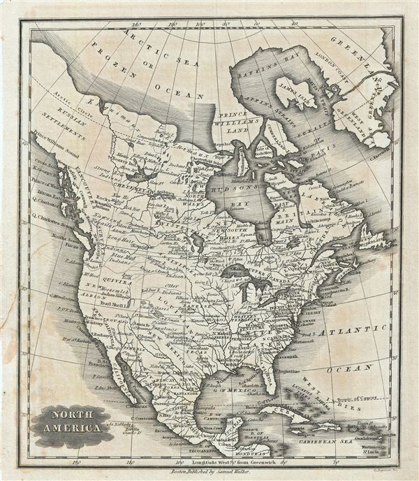
This is an attractive example of the 1828 Malte-Brun map of North America. It covers from Baffin Bay (Baffins Bay) to Honduras. This map predates the Mexican American War consequently most of California, New Mexico, and Texas are Spanish Territory. The mythical kingdom of gold, Quivara, a relic of 16th century Conquistador legends, is identified in modern day Oregon. Texas is identified as Tecas. The general lack of exploration in the Transmississippi is evidenced by the absence of Great Salt Lake. The Pacific Coast of the United States is here identified as 'New Albion,' a name given to the region by Sir Francis Drake, after he explored it and claimed it for england in 1579. Further north the Pacific Northwest follows the survey work of George Vancouver. Various Indian Settlements are identified, including Strong Bow Indians, Moozemlek Indian Village, Long hair Indians, Blue Mud Indians, Rocky Mountain Indians, and several others. Curiously, Greenland is divided into three parts following the early 19th century speculation that water channels lie hidden beneath the glaciers. Various, important rivers, islands, cities and other topographical details are noted. This map was published by Samuel Walker in 1828 as part of the American edition of Conrad Malte-Brun's System of Geography, Vol. I.
Cartographer
Conrad Malte-Brun (August 12, 1755 - December 14, 1826) was an important late 18th and early 19th century Danish / French cartographer and revolutionary. Conrad was born in Thisted, Denmark. His parents encouraged him to a career in the Church, but he instead enrolled in the University of Copenhagen. In the liberal hall of academia Conrad became an ardent supporter of of the French Revolution and the ideals of a free press. Despite the harsh censorship laws of crown prince Frederick VI, Malte-Brun published numerous pamphlets criticizing the Danish government. He was finally charged with defying censorship laws in 1799 and forced to flee to Sweden and ultimately France. Along with colleague Edme Mentelle, Malte-Brun published his first cartographic work, the Géographie mathématique, physique et politique de toutes les parties du monde (6 vols., published between 1803 and 1807). Conrad went on to found Les Annales des Voyages (in 1807) and Les Annales des Voyages, de la Géographie et de l'Histoire (in 1819). He also founded the Paris Société de Géographie . In time, Conrad Malte-Brun became known as one of the finest French cartographers of his time. His son Victor Adolphe Malte-Brun (1816 - July 13, 1889) followed in his footsteps, republishing many of Conrad's original 18th century maps as well as producing numerous maps of his own. The Malte-Brun firm operated well into the 1880s. More by this mapmaker...
Source
Malte-Brun, M., System of Geography, Vol. I. (Boston; S. Walker), 1828.
Condition
Very good. Blank on verso. Original platemark visible. Slight overall toning. Verso repair near left margin. Minor stains near bottom left margin.