This item has been sold, but you can get on the Waitlist to be notified if another example becomes available, or purchase a digital scan.
1846 Mitchell and Burroughs Map of North America
NorthAmerica-mitchell-1846$150.00

Title
North America.
1846 (dated) 15.5 x 13 in (39.37 x 33.02 cm) 1 : 23000000
1846 (dated) 15.5 x 13 in (39.37 x 33.02 cm) 1 : 23000000
Description
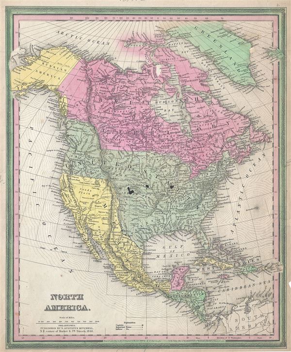
This is an important and scarce first edition example of S. A. Mitchell and H. N. Burroughs' 1846 map of North America. This hand colored lithographic map covers all of the United States, Canada, Russian America (Alaska), Mexico and Central America predating the Mexican American War and the Treaty of Guadalupe Hidalgo. The 1848 treaty, which formally ended the war, annexed all Mexican territory north of the Gila and Rio Grande Rivers, including the short lived Republic of Texas, to the United States, increasing the country's size by about 35%. Texas is shown in its grandest incarnation, extending north as far as the Arkansas River and west as far as the Rio Grande (or Rio de Norte), inclusive of much of modern day New Mexico, Colorado, and Kansas. A number of additional elements are of some interest, including an exceptionally narrow Lake Michigan.
Further north Mitchell sets the United States – British America border at 54°40' north latitude. This constitutes a strong stance in favor of American claims to the region. The Oregon Boundary Dispute, as it came to be known, evolved from conflicting commercial interests – mainly associated with fur trade – in the region. The British believed this territory fell into the land controlled by the Hudson Bay Company while expansionist Americans, championed by John Jacob Astor's Pacific Fur Company, asserted a claim to the region as far north as Russian America (Alaska). This conflict would eventually escalate into the 54°40' dispute. The turmoil ultimately gave rise to slogans like 'Fifty-four Forty or Fight!' and the catchphrase 'Manifest Destiny.' The dispute was not resolved until the 1846 Oregon Treaty which, through concessions on both sides, formally set the boundary at the 49th parallel.
The map thus details highly ephemeral period before the 1849 Gold Rush and the territorial reconfigurations that followed in the wake of America's great westward expansion. This is a rare transitional map produced by the mysterious engraver H. N. Burroughs, whose work for the Mitchell firm appears in 1846 between that of H.S. Tanner and Mitchell himself. Ristow notes, 'Nothing is known about Burroughs, but he was undoubtedly an employee or associate of Mitchell.' His fine and detailed work appears only in the hard to find 1846 edition of the Mitchell's Atlas. Dated and copyrighted 'Entered according to Act of Congress in the year 1836, by H. N. Burroughs in the Clerks Office of the Eastern District of Pennsylvania.' Issued as plate no. 2 in the 1846 edition of Mitchell's New General Atlas.
CartographerS
Samuel Augustus Mitchell (March 20, 1792 - December 20, 1868) began his map publishing career in the early 1830s. Mitchell was born in Bristol, Connecticut. He relocated to Philadelphia in 1821. Having worked as a school teacher and a geographical writer, Mitchell was frustrated with the low quality and inaccuracy of school texts of the period. His first maps were an attempt to rectify this problem. In the next 20 years Mitchell would become the most prominent American map publisher of the mid-19th century. Mitchell worked with prominent engravers J. H. Young, H. S. Tanner, and H. N. Burroughs before attaining the full copyright on his maps in 1847. In 1849 Mitchell either partnered with or sold his plates to Thomas, Cowperthwait and Company who continued to publish the Mitchell's Universal Atlas. By about 1856 most of the Mitchell plates and copyrights were acquired by Charles Desilver who continued to publish the maps, many with modified borders and color schemes, until Mitchell's son, Samuel Augustus Mitchell Junior, entered the picture. In 1859, S.A. Mitchell Jr. purchased most of the plates back from Desilver and introduced his own floral motif border. From 1860 on, he published his own editions of the New General Atlas. The younger Mitchell became as prominent as his father, publishing maps and atlases until 1887, when most of the copyrights were again sold and the Mitchell firm closed its doors for the final time. More by this mapmaker...
Horatio Nelson Burroughs (June 28, 1812 - August 23, 1896) was an engraver and later a banker based in Pennsylvania and active in the early 19th century. He was born in Washington Crossing, New Jersey. Burroughs' work first appears in conjunction with Henry Schenk Tanner and Samuel Augustus Mitchell (the elder). His name appears on the 1846 copyrights of many of Mitchell's earliest and most important atlas and pocket maps. Following 1846, Burroughs retired from engraving to become a banker, eventually becoming president of Commonwealth Bank. He married first Eleanor Douglas Mitchell (18?? - 1853), then, after her untimely death, her sister Caroline Mitchell (1818 - 1892), both daughters of map and atlas publisher Samuel Augustus Mitchell Sr. (1792 - 1868). Learn More...
Source
Mitchell, S., A New Universal Atlas Containing Maps of the various Empires, Kingdoms, States and Republics Of The World, 1846.
Condition
Good. Ink stains over the United States at three places. Minor overall toning and spotting. Blank on verso.
References
Rumsey 0537.003. Philips (Atlases) 6103.