This item has been sold, but you can get on the Waitlist to be notified if another example becomes available, or purchase a digital scan.
1861 Mitchell Map of North America
NorthAmerica-mitchell-1861$100.00

Title
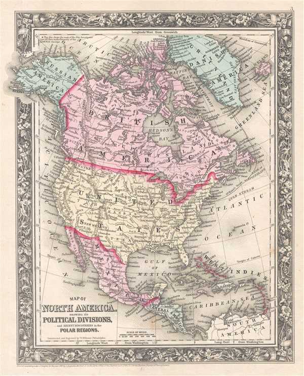
Map of North America. Showing its Political Division, and Recent Discoveries in the Polar Regions.
1860 (dated) 14 x 11.5 in (35.56 x 29.21 cm) 1 : 28000000
1860 (dated) 14 x 11.5 in (35.56 x 29.21 cm) 1 : 28000000
Description
This is an 1861 Samuel Augustus Mitchell, Jr. map of North America. The map depicts the continent from the Pacific Ocean to the Atlantic Ocean and from the Arctic Ocean to Colombia and Venezuela in South America.
Franklin's Lost Expedition and American Efforts to Locate It
The second Grinnell Expedition, which took place in 1853 and was led by Dr. Elisha Kent Kane, is illustrated leaving Brooklyn and heading north, in an effort to locate Captain Sir John Franklin's lost Arctic expedition. Franklin's wife, Lady Jane Franklin, appealed to the United States government after three British expeditions were unable to locate her husband. As Congress dithered in passing an appropriations bill in order to purchase ships, American merchant Henry Grinnell purchased two brigs, outfitted them for Arctic service, and offered them to the government, which contributed more funds and a volunteer crew of Naval officers and men. Both the first Grinnell Expedition (launched in 1850) and the Second were unable to locate Franklin and men that departed from England aboard two ships in 1845. International attention had already been focused on Franklin's disappearance, which was reinforced by the Admiralty's offer of a reward for finding the expedition. Songs were written about him, and a statue was erected in London in his honor.
Canada (British America), the United States, Mexico, and Central America comprise the regions labeled here, along with the islands in the Caribbean. No political divisions are illustrated within Canada or the United States, although regions in the western United States are given labels such as Nebraska, Kansas, Texas, New Mexico, Oregon, Washington, and New Mexico without including any borders. Cities throughout the continent are labeled, from Ottawa, Toronto, and Quebec in Canada to Caracas and Cartagena in South America. Rivers, lakes, and mountain ranges are also illustrated and labeled.
This map was constructed and engraved by W. Williams and published by S. A. Mitchell Jr. in the 1861 edition of Mitchell's New General Atlas. Like many American map publishers of this period, Mitchell did not regularly update his copyrights, consequently this map is dated and copyrighted to 1860: 'Entered according to Act of Congress in the Year 1860 by S. Augustus Mitchell Jr. in the Clerk's Office of the District Court of the U.S. for the Eastern District of Pennsylvania.'
CartographerS
Samuel Augustus Mitchell (March 20, 1792 - December 20, 1868) began his map publishing career in the early 1830s. Mitchell was born in Bristol, Connecticut. He relocated to Philadelphia in 1821. Having worked as a school teacher and a geographical writer, Mitchell was frustrated with the low quality and inaccuracy of school texts of the period. His first maps were an attempt to rectify this problem. In the next 20 years Mitchell would become the most prominent American map publisher of the mid-19th century. Mitchell worked with prominent engravers J. H. Young, H. S. Tanner, and H. N. Burroughs before attaining the full copyright on his maps in 1847. In 1849 Mitchell either partnered with or sold his plates to Thomas, Cowperthwait and Company who continued to publish the Mitchell's Universal Atlas. By about 1856 most of the Mitchell plates and copyrights were acquired by Charles Desilver who continued to publish the maps, many with modified borders and color schemes, until Mitchell's son, Samuel Augustus Mitchell Junior, entered the picture. In 1859, S.A. Mitchell Jr. purchased most of the plates back from Desilver and introduced his own floral motif border. From 1860 on, he published his own editions of the New General Atlas. The younger Mitchell became as prominent as his father, publishing maps and atlases until 1887, when most of the copyrights were again sold and the Mitchell firm closed its doors for the final time. More by this mapmaker...
Wellington Williams (1814 - July 8, 1875) was an American engraver based in Germantown, Philadelphia. Williams was born in Bath, England. He emigrated to England as a young man, establishing himself in Philadelphia as a map and line engraver. He most notably engraved the maps for both Samuel Augustus Mitchell and his son, Samuel Augustus Mitchell Jr. There is some evidence that Williams resented the relationship and derived little profit from the success of two Mitchell atlases. He also engraved for William C. Woodbrid and D. Appleton. In addition, Williams also published several maps and views under his own imprint. His home was located at 1857 Mervine Street, 20th Ward, Philadelphia. His offices were located in Philadelphia, on 5th Street, below Chestnut. He was interred at the Laurel Hill Cemetery, Philadelphia. Learn More...
Source
Mitchell, S. A., Mitchell's New General Atlas Containing Maps of the Various Countries of the World, Plans of Cities, Etc., embraced in Forty-Seven Quarto Maps, Forming a series of Seventy-Six Maps and Plans, together with Valuable Statistical Tables (Philadelphia: S. Augustus Mitchell, Jr.) 1861.
Mitchell's New General Atlas was published by Samuel Augustus Mitchell, Jr., the son of the prolific cartographer Samuel Augustus Mitchell. Many of the plates are derived from the his father's Mitchell's Universal Atlas, but not directly. The Mitchell's Universal Atlas was initially sold to Thomas, Cowperthwait, and Company in 1849, and again to Charles Deliver in 1856. It was Deliver who introduced the new vibrant color scheme, abandoning the older Mitchell's Universal Atlas green borders and themes for bright reds, blues, and yellows. Samuel Augustus Mitchell, Jr. acquired the Deliver plates in 1859. He added his own floral motif border, but doubled down on the vibrant color scheme, thus introducing to the American public the most vividly colored American atlas of the 19th century. In 1860, he published the first edition of his New General Atlas and, despite a slump in sales during the American Civil War, attained a level of success to rival his father. Mitchell would continue to publish the New General Atlas until 1887, when the firm formally closed.
Condition
Very good. Even overall toning. Light foxing. Blank on verso.
References
Rumsey 0565.003 (1860 edition).