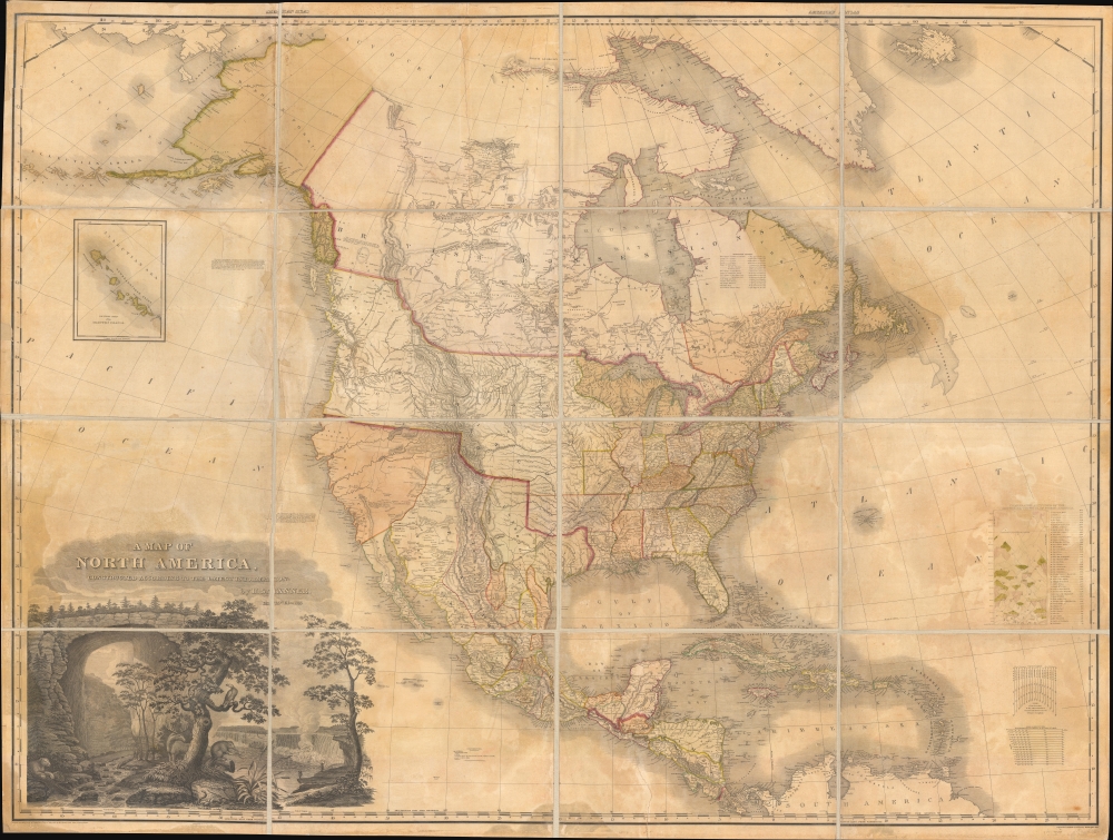
1825 Tanner Wall Map of North America
NorthAmerica-tanner-1825-2$12,000.00


Title
A Map of North America Constructed According to the Latest Information by H. S. Tanner.
1825 (dated) 45 x 59 in (114.3 x 149.86 cm) 1 : 7286400
1825 (dated) 45 x 59 in (114.3 x 149.86 cm) 1 : 7286400
Description
An example of Henry Schenk Tanner's 1825 landmark map of North America, considered to be the most important 19th-century map of North America. Revolutionary in countless ways, this is the most accurate map of North America the world of 1825 had yet seen, particularly the little-understood western parts. The task before Tanner in assembling this map, piecing together the cartography of an unknown country from piecemeal, often unreliable reports, was monumental. Tanner draws on Aaron Arrowsmith, Lewis and Clark, Alexander von Humboldt, Zebulon Pike, Stephen Harriman Long, Daniel Williams Harmon, George Vancouver, and others.
Much of the American west is unexplored. For coastal outlines, Tanner uses Vancouver. Inland, he relies on Zebulon Pike and Stephen Harriman Long, often recognizing and correcting, at great effort, discrepancies and inconsistencies. Longs Peak is identified and named as such for the first time. For much of the lands beyond the Rocky Mountains, Tanner relies on Humboldt's map of 1811. Although not based upon actual exploration, Humboldt was masterful at culling the wheat from the chaff when studying old missionary and conquistador reports and thus produced an impressively insightful map. The Sierra Nevada Mountains are not present. The Sierra Madre are in evidence but truncated at the northern ends. Tanner adds an annotation,
The cartographer identifies a hypothetical 'Great Bear Lake' just east of Prince of Wales Island. This is not to be confused with the factual 'Great Bear Lake' correctly located north of 'Great Slave Lake.' Apparently, this, along with much of the other information about the Pacific Northwest, was derived from the 1820 journal of Bennington, Vermont, native, fur trader, and explorer with the Northwest Company Daniel Williams Harmon (1778 - 1843). Harmon never saw the supposed lake himself but rather noted it in his journal based upon representations by Native Americans he encountered trading fur.
A Closer Look
The map is broad in scope, covering from the High Arctic and the Bering Strait to the northern part of South America. It includes all of North America, from Alaska to Panama, Greenland, Iceland, the West Indies, Central America, and the Aleutian Islands. The United States is presented according to pre-Mexican-American War boundaries. British Columbia, called New Hanover, is tied to the massive Oregon Territory extending as far north as 54° 40' Latitude - a claim that would later become an issue of international contention. The United States boundary with Mexico follows the 1819 Adams-Onís Treaty and runs along the Sabine River to the Red River, to the 100th Meridian West, to the Arkansas River, then west to that river's source at the 42nd parallel, which it follows to the Pacific.Much of the American west is unexplored. For coastal outlines, Tanner uses Vancouver. Inland, he relies on Zebulon Pike and Stephen Harriman Long, often recognizing and correcting, at great effort, discrepancies and inconsistencies. Longs Peak is identified and named as such for the first time. For much of the lands beyond the Rocky Mountains, Tanner relies on Humboldt's map of 1811. Although not based upon actual exploration, Humboldt was masterful at culling the wheat from the chaff when studying old missionary and conquistador reports and thus produced an impressively insightful map. The Sierra Nevada Mountains are not present. The Sierra Madre are in evidence but truncated at the northern ends. Tanner adds an annotation,
These Mountains are supposed to extend much farther to the north than here shewn: but there are no data by which to trace them with accuracy.Instead, Tanner follows earlier conventions and unreliable monastic reports by adding three fictional rivers: the Rio San Buenaventura, flowing from Lake Utah, labeled here Salt Lake; the Rio Timpanagos, flowing from Great Salt Lake, labeled here Lake Timpanagos; and the Los Mongos River, also flowing from Lake Timpanagos. Tanner funnels the Timpanagos River into San Francisco Bay, labeled here Port Sir Frans. Drake, which is, for all intent and purpose, unrecognizable as Vancouver, his primary source for the west coast, never explored the Bay Area.
The cartographer identifies a hypothetical 'Great Bear Lake' just east of Prince of Wales Island. This is not to be confused with the factual 'Great Bear Lake' correctly located north of 'Great Slave Lake.' Apparently, this, along with much of the other information about the Pacific Northwest, was derived from the 1820 journal of Bennington, Vermont, native, fur trader, and explorer with the Northwest Company Daniel Williams Harmon (1778 - 1843). Harmon never saw the supposed lake himself but rather noted it in his journal based upon representations by Native Americans he encountered trading fur.
Impressive Cartouche
In the lower left, there is a dramatic title cartouche featuring some of the flora, fauna, and natural wonders of America. Niagara Falls and the impressive Virginia Natural Land Bridge are prominent. The picture of Niagara is a combination of Vanderlyn's A View of the Westerly Branch, used for the Horseshoe Falls portion of the image, and the left part of his A Distant View of the Falls of Niagara, used for the American Falls portion of the image. In the foreground, some of the more important New World fauna - the beaver, a stag, and a bear - are presented. The cartouche does much to capture both the wildness and rich natural resources of the North American continent.Publication History and Census
This map was first issued in 1822; the copyright here reflects that date. There were 4 subsequent states, each with only minor updates and revisions. This is the fourth state.- State 1. First Edition. Does not include Franklin's Gulf in the Arctic or the 1824 Russian Boundary.
- State 2. Franklin's Gulf added.
- State 3. 1824 Russian boundary and 'Improved to 1825' added to title.
- State 4. 1825 boundary in the far northwest.
- State 5. Title changed to 'Improved to 1828.'
Cartographer
Henry Schenck Tanner (1786 - May 18, 1858) was one of the preeminent American map engravers and publishers of the early 19th century - what is considered to be the "Golden Age of American Map Publishing". Born in New York City but based in Philadelphia, Tanner's forty plus year career was almost entirely focused on cartographic work. His earliest map work appears in conjunction with another important map publisher, John Melish. Early in his career, Tanner partnered with his brother Benjamin, to engrave extensively for Melish as well as other Philadelphia publishers including Lucas Fielding (Baltimore), A. Bourne, Jason Torey, Samuel Harrison, and Samuel Lewis, among others. In 1818 Tanner convinced his fellow publishers and partners to finance the compilation of a New American Atlas. The atlas was sold by subscription and slowly emerged between 1819 and 1823. The New American Atlas, possibly the pinnacle of 19th century American cartography and was commended in its day as "one of the most splendid works of the kind ever executed in this country". It was subsequently republished in several updated editions until about 1839. Tanner had by this time become the most active and influential map publisher in the United States. Around 1832, recognizing the market for a less cost prohibitive atlas, Tanner began work on the smaller format New Universal Atlas. This popular and important atlas went through numerous editions before being bought out by Carey and Hart, and then, in 1846, by S. A. Mitchell, who would rise to become the preeminent publisher of the next generation. In addition to these important atlases, Tanner also issued numerous extremely important and influential travelers guides, state maps, wall maps, and pocket maps. He should not be confused with his brother, also an America map engraver, the New Yorker Benjamin Tanner. More by this mapmaker...
Source
Tanner, H. S., A New American Atlas, (Philadelphia: Tanner) 1825.
Condition
Good. Professionally restored and laid down on fresh linen. Some discolorations and dampstains throughout. Normally an 18,000 USD piece, here priced to accommodate further restoration.
References
Rumsey 2755.007. OCLC 11440047. Wheat, C. I., Mapping of the Transmississippi West, 1540 – 1861, #350, Vol 2, pages 82 - 87. Ristow, W., American Maps and Mapmakers: Commercial Cartography in the Nineteenth Century, pages 191-198.