This item has been sold, but you can get on the Waitlist to be notified if another example becomes available, or purchase a digital scan.
1826 Denham Map of Northern and Central Africa (Libya, Chad, Nigeria)
NorthernCentralAfrica-denham-1826$125.00

Title
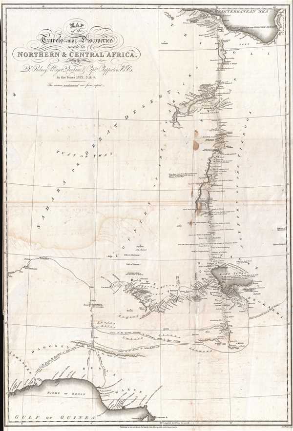
Map of the Travels and Discoveries Made in Northern and Central Africa by Dr. Oudney, Major Denham, and Capt. Clapperton, R.N.
1826 (dated) 24.5 x 16.5 in (62.23 x 41.91 cm) 1 : 5570000
1826 (dated) 24.5 x 16.5 in (62.23 x 41.91 cm) 1 : 5570000
Description
This is a scarce and intriguing 1826 map of North and Central Africa. The map depicts parts of Libya, Chad, Nigeria, and Benin, as well as several other African nations, although no 'international' borders are depicted. The map illustrates the expedition led by Walter Oudney, Hugh Clapperton, and Dixon Denham in detail. It traces their route from the Mediterranean Sea, close to the city of Tripoli, south through the Sahara to Lake Chad (Lake Tchad), and west from Lake Chad to Sackatoo. Many notes and waypoints are marked along their route, allowing the viewer to trace their journey. Although most of the area that they did not explore for themselves is left blank, supposed courses of the several rivers they did map have been included.The map was drawn to accompany Narrative of Travels and Discoveries in Northern and Central Africa, in the year 1822, 1823, and 1824 by Major Denham, F.R.S., Captain Clapperton, and the late Doctor Oudney. The book was published in two volumes in 1826, mostly under the guidance of Denham. Dixon Denham (1786-1828) served in the British army during the Napoleonic Wars. Denham joined the expedition late, joining Clapperton and Oudney in Tripoli in Novemer 1821. Hugh Clapperton (1788-1827) was impressed into the British navy and also served during the Napoleonic Wars. Walter Oudney (1790-1824) was a physician. Dr. Oudney had been appointed by the British government as consul for promotion and trade to the Kingdom of Bornu (shown on the map to the left of Lake Chad). Denham carried orders from the Colonial Office that, upon reaching Bornu, Oudney was to remain there, while he and Clapperton were to 'explore the Country to the Southward and Eastward of Bornu, principally with a view to tracing the course of the Niger and ascertaining its Embouchure'. When the three of them reached the Kingdom of Bornu in sub-Saharan Africa in February 1823, they became the first Europeans to accomplish a north-south crossing of the Sahara Desert. Oudney died a year later, while still on the expedition. Dixon and Clapperton did not get along, and had not since the beginning of their journey. Oudney's death failed to abate their mutual antipathy, and they did not speak to each other once during their return trip to Tripoli.
The map was published to accompany Dixon's Narrative of Travels and Discoveries in Northern and Central Africa, in the Years 1822, 1823, and 1824, which was published in two volumes. The map was engraved by J. and C. Walker, and published by John Murray in London in 1826.
The map was published to accompany Dixon's Narrative of Travels and Discoveries in Northern and Central Africa, in the Years 1822, 1823, and 1824, which was published in two volumes. The map was engraved by J. and C. Walker, and published by John Murray in London in 1826.
Cartographer
John Walker (1787 - April 19, 1873) was a British map seller, engraver, lithographer, hydrographer, geographer, draughtsman, and publisher active in London during the 19th century. Walker published both nautical charts and geographical maps. His nautical work is particularly distinguished as he was an official hydrographer for the British East India Company, a position, incidentally, also held by his father of the same name. Walker's maps, mostly published after 1827, were primarily produced with his brothers Charles Walker and Alexander Walker under the imprint J. and C. Walker. Among their joint projects are more than 200 maps for the influential Society for the Diffusion of Useful Knowledge Atlas (SDUK). In addition they published numerous charts for James Horsburgh and the British Admiralty Hydrographic Office, including Belcher's important map of Hong Kong and Carless' exploratory map of Karachi. The J. and C. Walker firm continued to publish after both Walkers died in the 1870s. More by this mapmaker...
Source
Denham, D., Clapperton,H,. and Oudney,W.,Narrative on the Travels and Discoveries in Northern and Central Africa in the years 1822, 1823, and 1824.
Condition
Very good. Slight transferrance. Minor soiling. Backed on archival tissue for stability.
References
New York Public Library, Rare Books Division, Sc Rare 916.7-D. OCLC 258001339.