This item has been sold, but you can get on the Waitlist to be notified if another example becomes available, or purchase a digital scan.
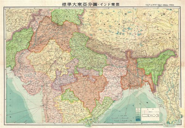
1943 or Showa 18 World War II Era Japanese Map of Northern India, Pakistan and Afghanistan
NorthernIndia-showa18-1943$125.00

Title
Northern India.
1943 (undated) 30 x 21 in (76.2 x 53.34 cm) 1 : 450000
1943 (undated) 30 x 21 in (76.2 x 53.34 cm) 1 : 450000
Description
This is a beautiful 1943 or Showa 18 map of northern India issued by the Japanese during World War II. It covers all of northern India, Pakistan and Afghanistan. The map offers superb detail regarding topographic and political features and notes cities, roads, and trade routes on air, sea and land. Shading is used to display oceanic depths.
This map was issued before India gained independence from the British and hence, Pakistan is shown to be part of India. While India was in the midst of its struggle for freedom. The British Raj however, was still in control of the country, which led to India's participation in World War II.
This map was created by the Japanese during World War II and issued as part of a 20 map Series of Great East Asia Maps, detailing parts of Asia and the Pacific. All text is in Japanese.
Condition
Very good. Wear along original fold lines. Blank on Verso. Accompanied by original cover.