1682 Visscher Map of Northern Spain and the Basque Region
NorthernSpain-visscher-1682$1,250.00

Title
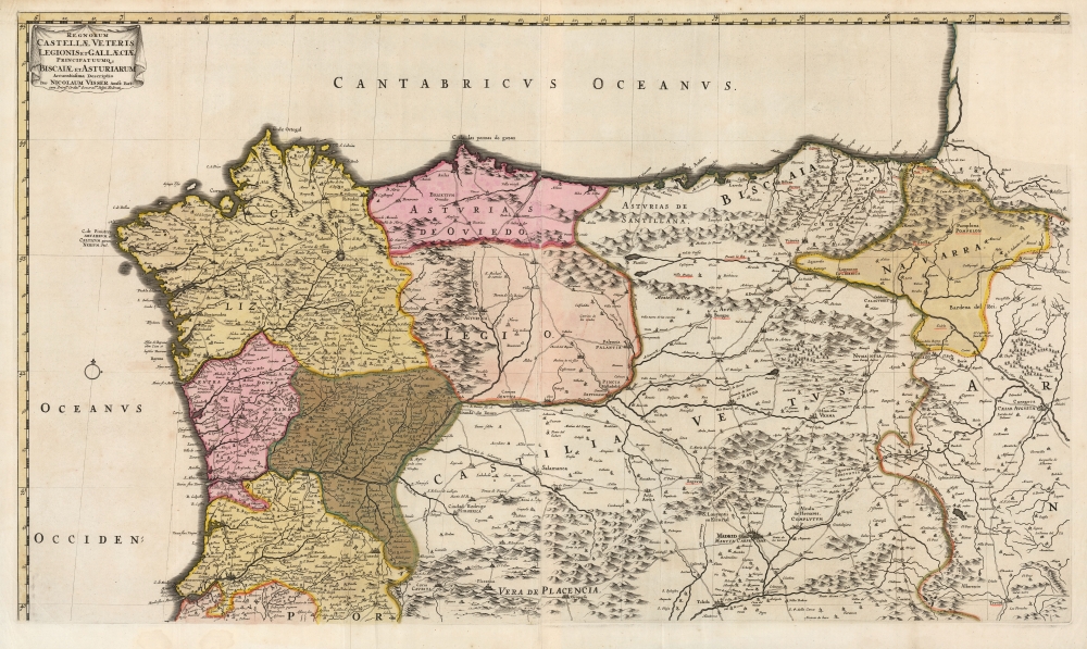
Regnorum Castellæ veteris Legionis et Gallæciæ principatuumque Biscaiæ et Asturiarum accuratissima descriptio.
1682 (undated) 18.5 x 32.25 in (46.99 x 81.915 cm) 1 : 1000000
1682 (undated) 18.5 x 32.25 in (46.99 x 81.915 cm) 1 : 1000000
Description
This is a beautiful example of Nicolaes Visscher II's 1682 map of northern Spain and Portugal. The map covers the main pilgrimage routes to Santiago de Compostela from the Pyrenees to Galicia.
A Closer Look
Coverage extends from the mouth of the Mondego River in the south to the Spanish coast on the Bay of Biscay; and from the Iberian Atlantic coast in the west to the Aragon region, and the city of Zaragosa. It includes rich detail of the Basque regions of Biscay and Navarre. Mountains are depicted pictorially, and provinces are distinguished with original outline and wash color. In addition to Zaragosa, many other cities of such as Pamplona, Madrid, and Salamanca are shown.Curious Underlined Cities
Selected cities have been underlined in red, mainly within the provinces of Biscaia and Navarre. In Castile, the city of Burgos is thus highlighted; the significance of these cities is admittedly lost: if pilgrimage spots, why is Santiago de Compostela not also underlined? Many of these sites, but not all, were the site of battles in the 1813 Peninsular War - terribly late for this work to have retained relevance, but for the purposes of recording key battles it may have been sufficient.Publication History and Census
This map - two printed sheets, joined - was intended as part of a six-sheet map of the Iberian Peninsula, and first printed in 1682. Visscher does not appear to have had these as part of a regular atlas, but they do occasionally appear in composite atlases of the latter 17th century and early 18th century, such as that of Danckerts. We see 16 examples catalogued in institutional collections.Cartographer
Nicolaes Visscher II (September 30, 1649 – May 31, 1702) was a Dutch engraver, cartographer and publisher: he was born into the trade, the son of Nicolaes Visscher I and the grandson of Claes Janszoon Visscher. He produced a number of maps to add to the family atlas, as well as for inclusion in other composite atlases. After his death, his wife, Elisabeth, continued the family tradition of mapmaking and publishing. The plates and remaining stock were then sold to Peter Schenk, who reprinted them under his own name. More by this mapmaker...
Condition
Excellent. Some creasing at folds, else fine with bright original wash and outline color.
References
OCLC 212589466.