1868 Beers Map of Hempstead, Long Island, New York
NorthHempstead-beers-1868$300.00

Title
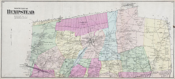
North Part of Hempstead Queens Co. L. I.
1868 14 x 31 in (35.56 x 78.74 cm)
1868 14 x 31 in (35.56 x 78.74 cm)
Description
This scarce and large hand colored map depicts the town of Hempstead, Long Island, New York. Map depicts the populous cities and towns surrounding Hempstead, including Garden city, Valley Stream, Bridgeport, Rockville, Greenwich Point, Smithville, Ridgewood and New Cassel. The extraordinary detail of this map, down to individual households with family names, make it a fascinating study for the family researcher or historian.
Cartographer
The Beers family (Fredrick, Silas, James and Daniel) (fl. c. 1850 - 1886), along with Charles and Augustus Warner, were prominent map publishers working from the 1850s to the late 1880s. Often publishing under the Warner & Beers designation, the combined firms produced a series of important state and county atlases and map of much of the northeastern United States. Many of their regional maps are among the most detailed and well laid out maps ever produced of their respective regions. Because Warner & Beers county maps were often detailed down to the individual homes and landowners, they have become highly sought after by general and family historians. In additional to producing maps of surpassing detail, Warner & Beers also maintained an earlier generation's attention to detail and quality while publishing in an era ever increasingly dominated by the low cost printing methods used by the publishing empires of Rand McNally and George Cram. More by this mapmaker...
Condition
Very small burn to right margin, see photo Else, fine or perfect condition. Wide clean margins. Rockaway, Hewletts and Woodsburgh maps on verso.