This item has been sold, but you can get on the Waitlist to be notified if another example becomes available, or purchase a digital scan.
1892 Rand McNally Map of the North Pole or Arctic Regions
NorthPolar-randmcnally-1895$62.50

Title
Map of North Polar Regions.
1892 (dated) 20 x 13.5 in (50.8 x 34.29 cm)
1892 (dated) 20 x 13.5 in (50.8 x 34.29 cm)
Description
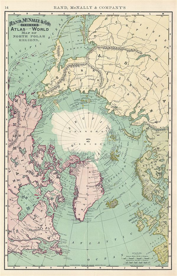
This is a beautiful example of Rand McNally and Company's 1892 map of the North Pole, Arctic, or Northern Polar Regions. It covers from ezo (Yesso or Hokkaido), Philadelphia, and Portugal north to the Pole. This map offers an excellent overview of the state of Arctic exploration and discovery to about 1892. Various Arctic expeditions noted, including those of Robert edwin Peary 1892, the Swedish Arctic expedition 1868, Fredrik Hjalmar Johannesen 1871, Long 1867, and James Cook 1778, among others. The sea between Japan and Korea, whose name, either the 'Sea of Korea' or the 'Sea of Japan,' is currently a matter of historical and political dispute between the two countries, is here identified in favor of Japan. The whole is color coded according to continents with rivers and various other topographical details with relief shown by hachure. This map was issued as plate no. 14 in the 1895 issue of Rand McNally and Company's Indexed Atlas of the World - possibly the finest atlas Rand McNally ever issued.
Cartographer
Rand, McNally and Co. (fl. 1856 - present) is an American publisher of maps, atlases and globes. The company was founded in 1856 when William H. Rand, a native of Quincy, Massachusetts, opened a print shop in Chicago. Rand hired the recent Irish immigrant Andrew McNally to assist in the shop giving him a wage of 9 USD per week. The duo landed several important contracts, including the Tribune's (later renamed the Chicago Tribune) printing operation. In 1872, Rand McNally produced its first map, a railroad guide, using a new cost effective printing technique known as wax process engraving. As Chicago developed as a railway hub, the Rand firm, now incorporated as Rand McNally, began producing a wide array of railroad maps and guides. Over time, the firm expanded into atlases, globes, educational material, and general literature. By embracing the wax engraving process, Rand McNally was able to dominate the map and atlas market, pushing more traditional American lithographic publishers like Colton, Johnson, and Mitchell out of business. Eventually Rand McNally opened an annex office in New York City headed by Caleb S. Hammond, whose name is today synonymous with maps and atlases, and who later started his own map company, C. S. Hammond & Co. Both firms remain in business. More by this mapmaker...
Source
Rand McNally & Co., Foreign Countries. Rand, McNally & Co's Indexed Atlas of the World (Complete in Two Volumes)…, (Chicago) 1895.
Condition
Very good. Minor verso repair near bottom margin. Map of Eastern Hemisphere and other smaller maps on verso.
References
Rumsey 3565.004 (1897 edition). Philip (atlases) 1026 (1898 edition).