1876 Bauman Map of the North Pole
NorthPolarRegion-bauman-1876$950.00

Title
Map of the North Polar Region.
1876 (undated) 26.25 x 33 in (66.675 x 83.82 cm) 1 : 11675000
1876 (undated) 26.25 x 33 in (66.675 x 83.82 cm) 1 : 11675000
Description
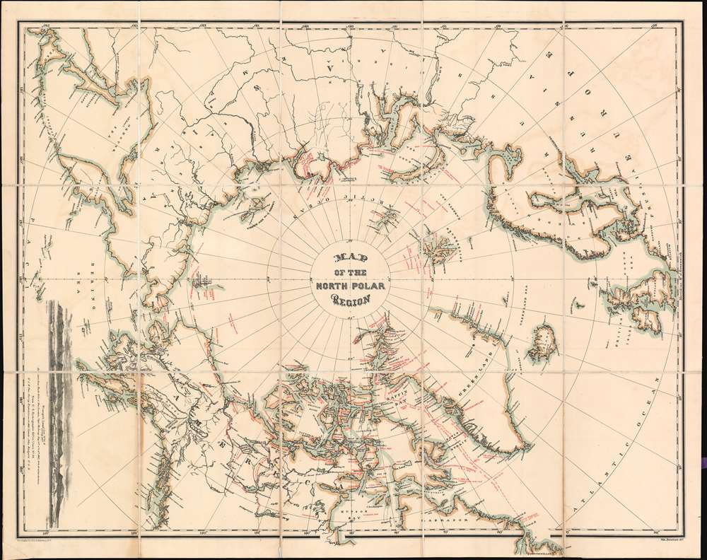
This is an 1876 William Bauman map of the North Polar region highlighting over four hundred years of exploration. Centered over the North Pole, the entire world is depicted to at least sixty degrees latitude and lower in some places. Countries are labeled, but no national boundaries are marked. Very little inland detail is present; only a handful of cities are labeled, and lakes and rivers are illustrated in Canada, and Siberia.
Tracing the History of Arctic Exploration
Red overprinting notes expeditions by their leaders' names, including Barents, Hudson, and Parry, and provides the years of their journeys. Dashed lines in North America trace Sir John Franklin's expeditions in Canada between 1819 until 1826 before he disappeared on his fatal final voyage in 1845. Several subsequent teams, including the Richardson and Rae Expedition in 1848, went out in search of Franklin, but never learned their fate. Siberian coastlines, as determined by Nordenskiold in the late 1870s, also appear in red and are significantly different than the accepted coastlines printed here in black.The Polaris Expedition
Perhaps the most puzzling notation is a dashed line through the Baffin Bay and the Davis Strait to Newfoundland that reads 'Track of Ice Floe Party of U.S. Polaris from October 14th, 1872 to April 30th, 1873'. This refers to the disastrous Polaris Expedition, which was one of the first American attempts to reach the North Pole. Commanded by Charles Francis Hall, who also led several expeditions into the Arctic to try and find the lost Franklin expedition, the Polaris left New York in June 1871. The expedition dealt with insubordination from the start. Led by the Germans Emil Bessels and Frederick Meyer, the expedition's chief scientist and meteorologist, the crew quickly divided by nationality and tensions never abated. Hall died in October after returning from a scouting expedition, and accused several of the crew, including Bessels, of poisoning him before he succumbed to illness. The Polaris and its crew suffered through an icebound Arctic winter. Even after losing its commander, and suffering through winter, an attempt was made at the North Pile. Nonetheless, they did not get far before being called back to the ship. The Polaris hit an iceberg on the way south and could not be freed. To free the ship, stores and supplies were haphazardly thrown overboard. Not a day later, the ship was forced to run aground at Etah due to a lack of coal for fuel. This forced the crew to spend another winter in the Arctic which they survived only with the help of the Etah Inuit. Interestingly, part of crew did not winter at Etah. On the night when the Polaris hit the iceberg, some men camped on the ice off the ship. During the night, the ice broke apart, and when they awoke, these men found themselves ten miles from the Polaris and were unable to get the ship's attention. They spent the next six months drifting over 1,800 miles on an ice floe before being rescued off Newfoundland by a whaler.Publication History and Census
This map was drawn by William Bauman and published by The Graphic Company in 1876.Condition
Very good. Exhibits slight offsetting. Dissected and mounted on linen. Old linen generally stable but reinforced in places.
References
OCLC 11600416.